|
|
IBEXtrax.com - Cascade Mountains of Washington StateAlpine Lakes Wilderness |
|
|
It was Wednesday when I was pouring over my maps and thumbing through the guide as Chris walked in. The air was tense. But still, we began to talk. I hadn't seen him since the completion of the fifty mile Olympic Beach Wilderness trek. I asked him to go up to Peggy's Pond with me, and he seemed relieved. He told me that he thought I was mad at him for not bringing me along with him on the Olympic Beach hike. With that settled, we planned and packed.
Friday afternoon found my Cortina winding along the familiar road toward Fish Lake Guard Station above Salmon la Sac. The track follows the same path, but the surface is ever-changing. Some memorable experiences include: 1) Doug H and I enroute to Paddy-Go-Easy Pass and finding the road completely washed away at Camp Creek. We spent the weekend wandering in the fog on Davis Peak; 2) One winter a slide came down off Goat Mountain and blocked the Cle Elum River and continued across the valley to obliterate the road with a tangle of trees and boulders; 3) Early in 1973 when I came up the road, I had to plow through snowdrifts so deep, that the engine compartment of my car became packed with snow.
The Cle Elum River Road had aged three months since my last visit. Now behind the Cortina, rose a gigantic rooster tail of dust. The parking lot was crowded with hunters, horses, horse trailers, trucks, and a couple of church groups. I parked strategically for a compression start because the little ford had been giving me trouble. It was hot and I broke into a sweat by simply lacing my boots. We hoist our packs and crossed the bridge over the Cle Elum River.
The familiar trail and I, go way back into the Boy Scout era. The first trip in the early sixties was followed by an almost annual pilgrimage to Deep Lake. That tradition ended with my enlistment into the Green Machine. My most recent trek up the long switchbacks from the Cle Elum River did not bring me to Deep Lake, but led me to the climbers trail to Peggy's Pond.
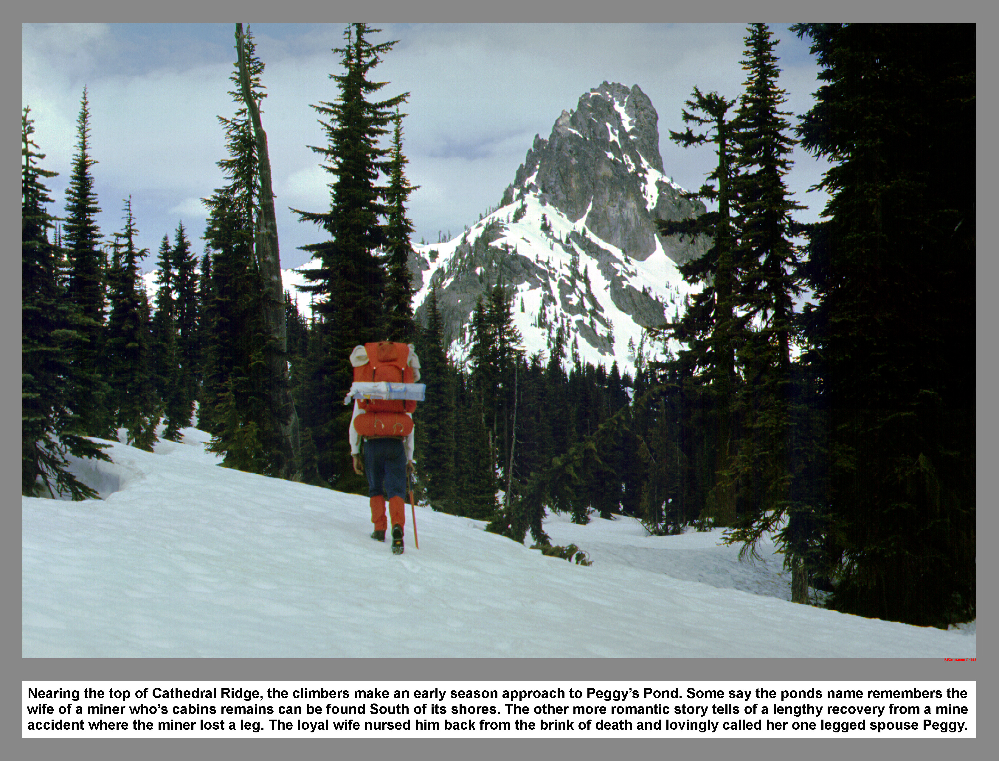
The trail is well maintained and complies with grade standards for like stretches of the Cascade Crest Trail. I settled into a dogged pace and sunk into a zombie state. Along the trail, you can't see the forest through the trees. At the top of the fourth switchback the way is confusing. 100 Hikes states, "A small brook at one mile provides water. Here an abandoned trail may still be evident in switchbacks up to the left, but the main trail continues straight ahead at a more moderate grade." Anyway, at the top of the fourth switchback, where number five switchback climbs up left, some people have "continued straight ahead at a more moderate grade." This lost mans trail is well beaten and may have bright red markers to lead the confused hiker astray. The top of the fourth switchback is not the one mile mark because the real trail goes up left through some muddy patches and continues to climb to Squaw Lake at two and one half miles.
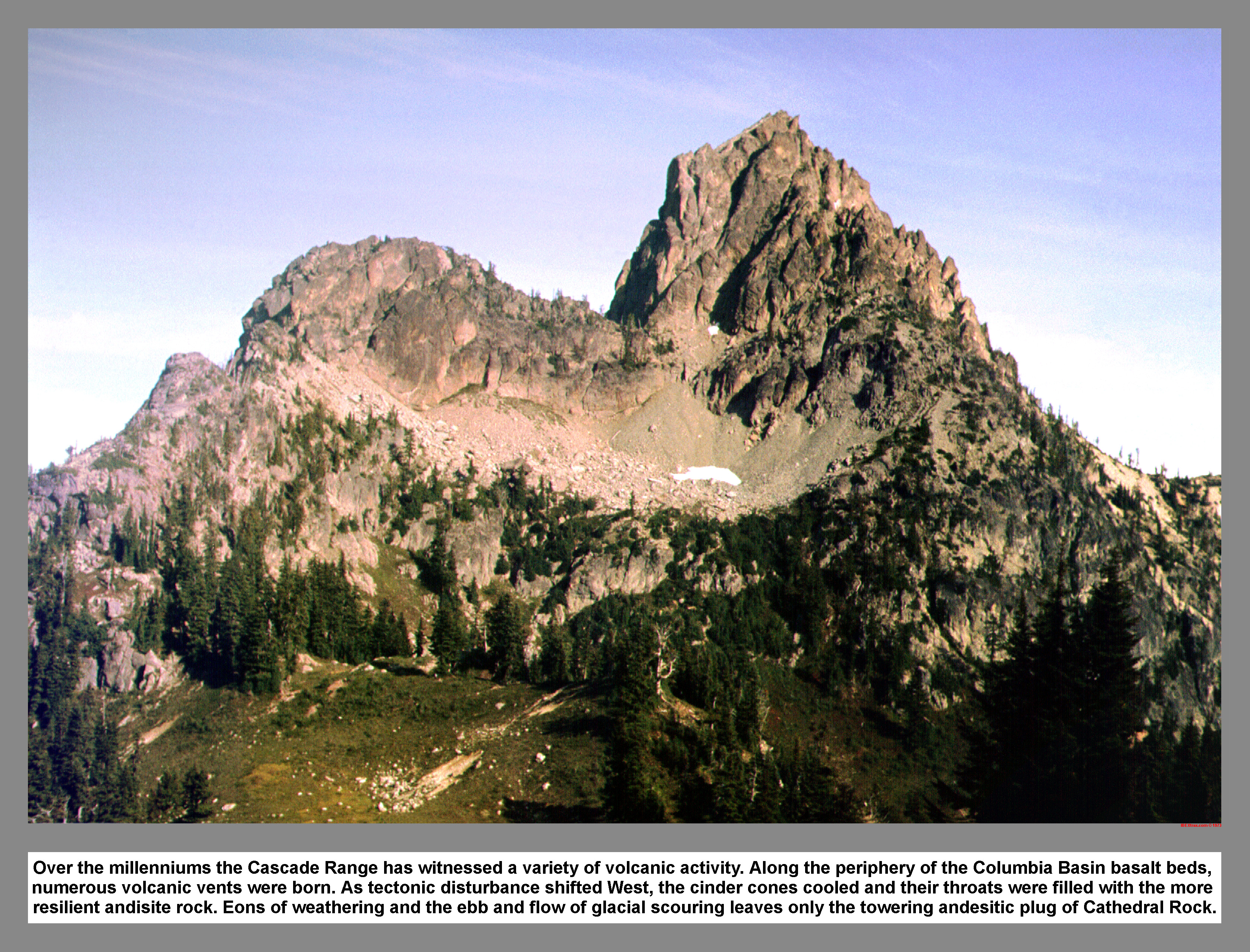
We stopped at the lake, and I used the facilities located one hundred feet south of the lake-trail junction. Chris and I continued up the next steep section of trail northwest of the lake. The trail leveled off and entered the meadow area. The pleasant traverse to Cathedral Pass was augmented with views of Mount Stuart and the andesitic plug of Cathedral Rock.
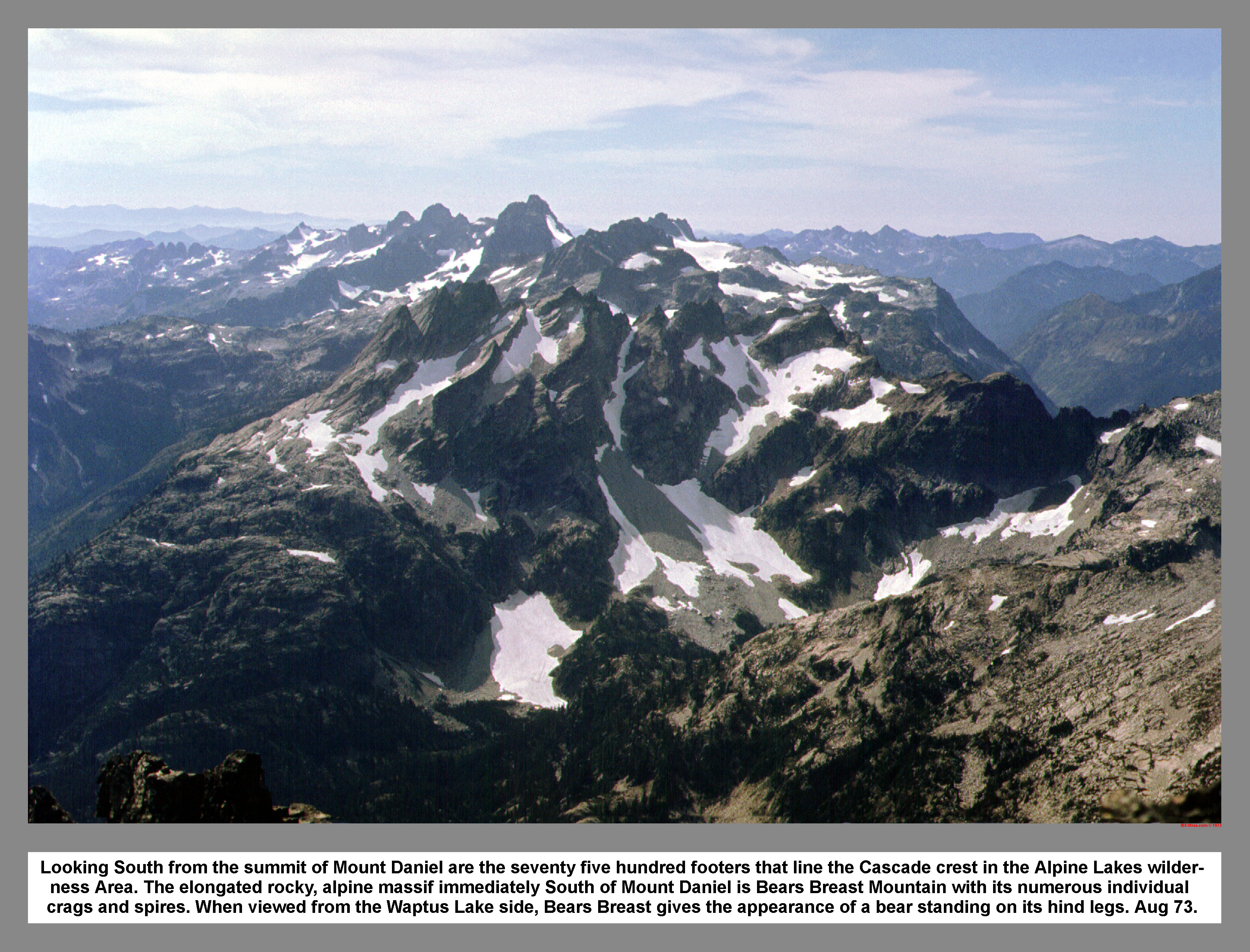
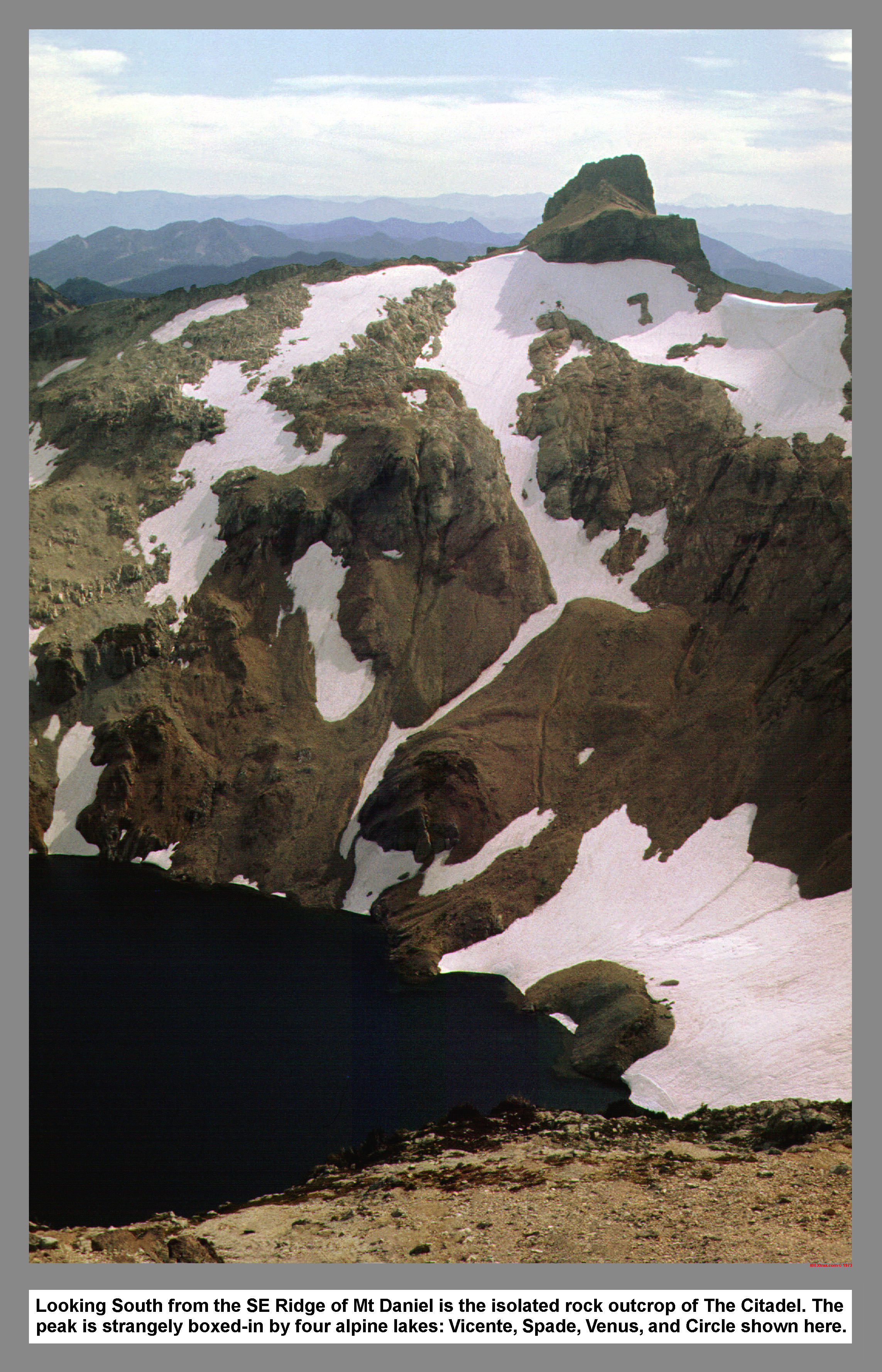
As we broke over the pass, The Citadel rose across the Spinola Valley. A thin ribbon of water fell from 6000' Circle Lake to the large and sparkling Deep Lake. The immense shoulder of Mount Daniel obscured the true summit from our view. Cathedral Rock was a neck racking sight from our foreshortened view.
I disengaged my climbing gears and let my weight glide down the Deep Lake side of the pass. At the end of the first switchback, four-wheel drive was in order for the goat-climbers trail lead toward Peggy's pond. The half mile traverse around the base of Cathedral Rock was done in good time, with increasing spirit of alpine adventure. As Chris and I topped the knoll south of the pond, I was glad to see that our detour off the main trail had panned out to be rich in solitude.
We pitched Chris' tent one hundred feet west of the pond. We lazed around and watched the shadow of Mount Daniel climb Cathedral Rock. I decided that I liked Peggy's Pond without the covering of snow it had on my two previous visits. I was inclined to agree with Beckey in reference to the pond; "Its sharply defined circular shoreline makes it a gem among wilderness lakes."
Supper was cooked on the trusty Sevea. After eating, we retired for the night. The night was calm and warm, in contrast to our previous visit when we awoke with four inches of new snow on the ground.
The morning was crisp and clear. I cooked breakfast. After eating, I was packed before Chris had started. So, I strolled off toward the moraine debris that was once carried by the now stagnant Hyas Creek Glacier. I climbed above the moraine and then frictioned up to the top of a glacial polished knoll. When Chris arrived, I pointed out the small birds that were apparently feeding on the glacier.
We donned crampons and roped up before we stepped onto the glacier. The Hyas Creek Glacier is a small remnant of a once mighty mass, but now some consider it to be dead. Since we had brought the rope and crampons we used them. Our route took us over a flat corner of the glacier. We ascended a steep gully that was part Ice, but mostly water and scree. The crampons bit well in the dirt. Above the rubble filled wash, we climbed with switchbacks, up steeper slopes until our contorted ankles brought us to the talus below the East Peak. We stowed the snow gear in our packsacks and made our way to the summit.
Even though I had stood there the year before, the view was still breath taking. The bench mark, of course, was still there. As was Paul's writing in the bottle. After a short rest we headed west. Unlike the year before, we were bound for the true Summit.
Chris led down to the saddle. On that treacherous climb I vividly remember inching around an exposed corner in the "crab walk" position. The rock was shattered and loose. From the saddle, Venus Lake appeared; down and to the south. Only a few chunks of ice remained on the lakes surface. To gain the ridge above the saddle we trudged through deep loose scree. Once on top of the saddle the footing improved. We passed below the Middle Peak on a slightly sun cupped snowfield, and then took a straight shot to the West Peak. When we arrived on the rocks below the true summit, Chris took an other than easiest route to increase the excitement and adventure. I scrambled around to the left and met Chris on top.
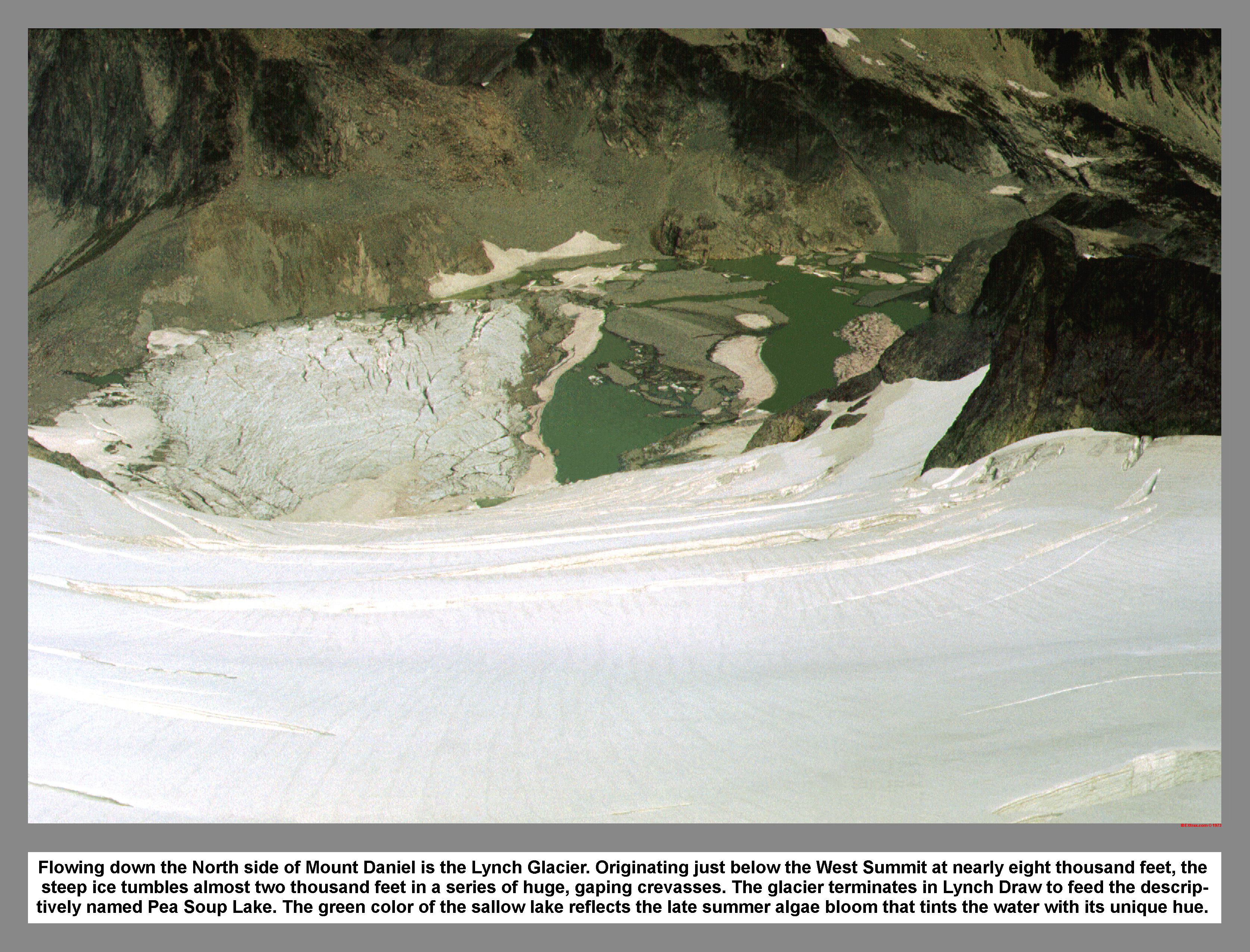
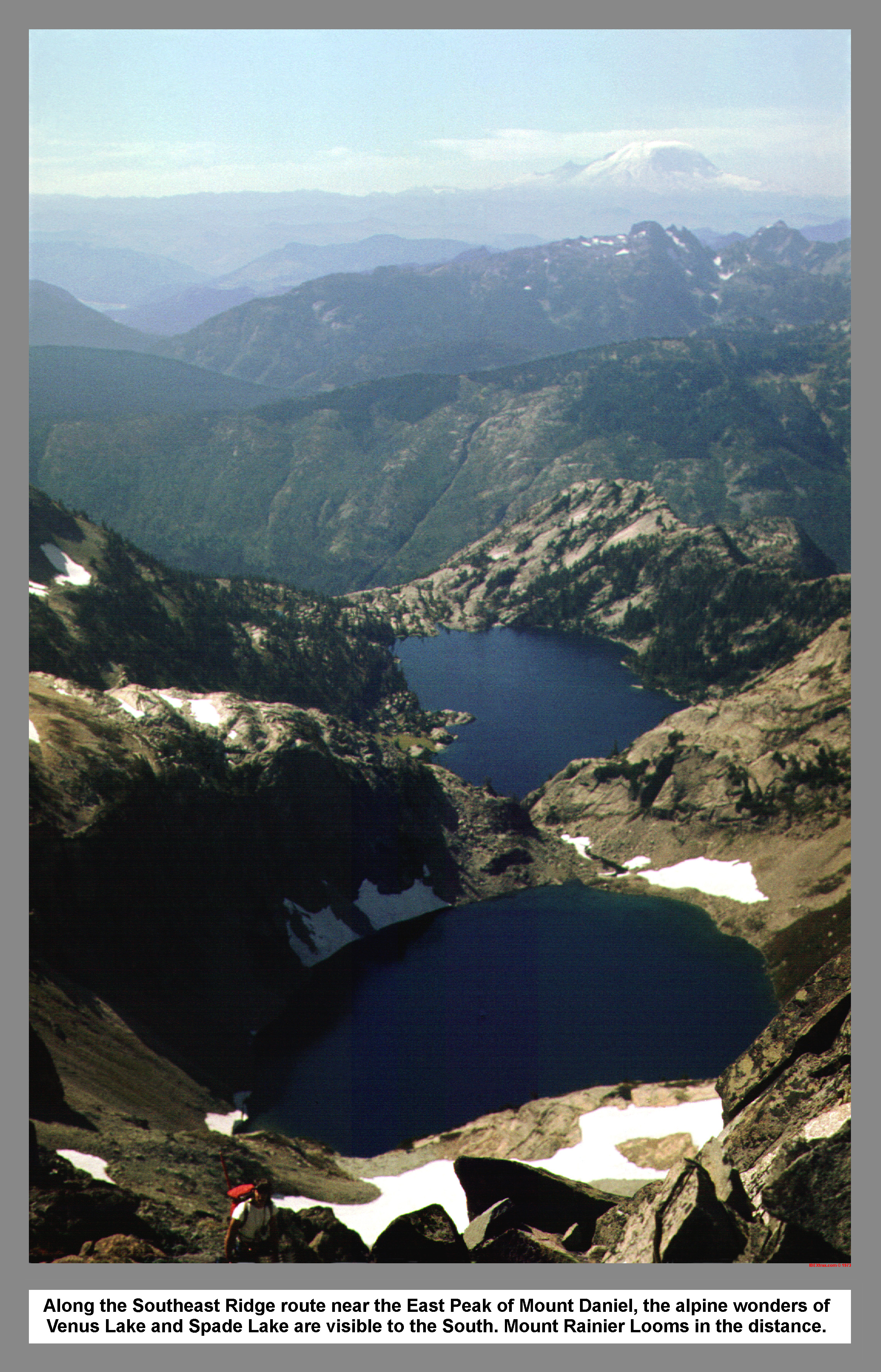
From the summit the most notable attraction is at the bottom of the brutally crevassed Lynch Glacier. The guide called it Pea Soup Lake. The combination of green algae and the milky glacial melt water made the naming very descriptive and appropriate. Spade Lake, in the opposite direction and of natural appearance, was deep blue. Beyond, rose the most stately and rugged peaks of the south central cascades. We signed the Alpine Roamers summit register and then sat back to admire the view and eat a light lunch.
After lunch we scrambled down the easy way and retraced our tracks past the Middle Peak. Our route to the saddle was down a snow slope above the Daniel Glacier. A climbers trail brought us to a notch on the southeast ridge; above the Hyas Creek Glacier. We decided not to descend due to a crevasse and a few rock outcroppings. A dash-and-gasp plunging traverse ended on the southeast ridge overlooking Circle Lake.
The Hyas Creek Glacier to the north was a smooth tilted surface. It looked Inviting. We secured our gear and I slipped on my rain pants. We stood on the top of a broken down cornice and played the traditional stall games; "Go ahead, you go first." Chris lost and pushed off, checking his speed and testing the surface. I followed doing the same thing until my confidence was strengthened. I swung out of Chris' tracks and shot past him. My lust for speed was battling with my sense of safety. With great excitement and a few pops of my ears, four hundred vertical feet disappeared above me.
As my speed diminished I sat back on my slick rain pants and held my aching legs above the snow. I used my axe either as a paddle or a break to keep my feet pointed down hill. When I finally stopped I looked back to see Chris plunging toward me. We skated down the remaining glacier and scrambled down some polished bedrock.
A traverse right brought us to the top of a small steep snow patch. I decided to start in the sitting position. However, halfway down I decided It was a mistake. I was going way to fast. So, I rolled over into a poor arrest position. Seeing that I wasn't slowing down, I flopped back over and managed to get to my feet and stop. I warned Chris not to sit down because it was too bumpy.
After the bumpy glissade we started down together. But, I fell behind trying to recuperate from the jolting slide. At the top of a gully I stopped for a rest and studied Cathedral Rock in anticipation of tomorrow's ascent. Eventually I gave up trying to find the northwest couloir route, so I headed down the gully. While descending, I found a family of marmots and we whistled at each other.
Back at the camp at Peggy's Pond, seeing that two hours of light remained, Chris and I decided to go search for the northwest couloir on Cathedral Rock. Chris didn't take his pack and I only packed a few essentials. We went around the lake, and then headed up over heather and through small clumps of trees. We made good time up the rubble in the lower corral. At the top of the funnel we swung right and followed a dirty ledge that provided easy walking.
About two hundred feet south of the funnel, Chris scrambled up what he thought was the Northwest Couloir. I scrambled around the corner and found a better route. I started up, but almost immediately a volley of dirt and rocks came sliding by me. I made for cover and waited. I debated with myself about going back down. However, I eventually continued up in search of Chris. The route was mostly dirt with a few loose boulders and assorted root holds. I came up over a bulge and met Chris standing in the upper cul-de-sac. He looked bewildered.
I glanced at a copy of the guide and dropped my pack to duck under the massive chock stone that blocked the way. After twenty feet of stemming in the enclosed chimney, I continued to stem the upper open part. At the top of the chimney was a descending ring rappel anchor. As Chris came up the chimney, I climbed around a corner and then saw a piton with and a REI oval attached. I was thinking about climbing down when Chris arrived. Our discussion ended on a note of danger, so I frictioned up a sloping slab using a large flake on my right as a handrail. From the top of this "escalator", broken slopes brought me to within one step of the summit.
A moment of contemplation was interrupted with a nudge from a gusty northerly. I stepped across to the summit. The wind and I were chaperoned by a four foot summit cairn. I stepped back across as Chris arrived and started back down for my camera. Down out of the wind I skillfully renegotiated the escalator and the chimney. From my sack at the top of the cul-de-sac, I secured my Yashica and climbed back to the top with increasing confidence. I snapped a flick of Chris on the top. The parking lot was visible down on the left, and to the right Deep Lake, now in the shadows. The Deep Lake outlet flowed onto Spinola Flats. An extra lake named Deer, hung in the bench land below The Citadel.
I led down to the chimney and asked Chris to pose in the chimney. I snapped a flick of the most technical climbing I had ever done. Going back down the couloir, Chris sent a huge rock rumbling down below us. We named it "big loosey". We entered into the lower corral before the gate. We took separate open books, and then we screed until the slopes gave way to stunted evergreens and heather. After reaching Peggy's Pond, we chatted with a party of new arrivals and then reached the camp at dusk.
Sunday morning we slept in, extinguishing our chance to climb The Citadel. After breaking camp we packed back to Cathedral Pass. At the ponds south of the pass we talked with an overweight hunter with a donkey. We ate lunch at Squaw Lake and watched a dragonfly maneuver in the tall grass. Just below the lake we passed two horsemen and were tailgated all the way to the Cle Elum River. Once reaching the parking lot, we watched some hunters load an almost unloadable horse. My strategic parking paid off for a compression start of the Cortina, and then we rolled back down the Cle Elum River Road in a billowing cloud of dust.
|
|
|
|
|
|
This site created and maintained by THE IBEX - Page last revised:
|
|