|
|
IBEXtrax.com - Cascade Mountains of Washington StateMount Rainier Park |
|
|
I was alone when I drove in the White River Entrance of Mount Rainier National Park. I was relieved to find that there was no entrance fee charge for entering the park. The sign read, "All hikers and climbers must have back-country permits." I knocked on the door of the Rangers Headquarters. A young man with a full beard opened the door. I told him that I needed a back-country use permit for Owyhigh Lakes, and that I was also going to climb up off the trail. The Ranger had to call to the reservation desk on the other side of the park. He told me of the recent difficulty he had getting reservations for Storbo Camp in Glacier Basin. However, my permit for Owyhigh Lakes went through easily, and soon I was back on the road for the few miles up to the small parking lot and trailhead.
I figured that it was only two or three hours of daylight remained in the day. So I quickly laced into my boots and hoist my pack. It was three and a half miles to the lakes, so I hiked without rest. The trail was wide and well kept, except for an occasional hoof-hole from the horse traffic. I kept track of the number of switchbacks to relieve the boredom. By the time I reached the bridge near the designated campsites, I had counted seven switchbacks. The campsites below Owyhigh Lakes are developed to save the fragile area around the lakes from deep lugged boot prints and tent ditching. I hiked on. On the west side of the main lake I found not a single remnant of the shelter that was marked on the map. The last day light had gone from that Friday evening. I pitched my tent in a dry stream bed at the south end of the main lake. A grove of Hemlock trees blocked the view of the trail. I changed from a sweat soaked T-shirt into a down sweater to combat the freezing air. I brewed up some hot chocolate on my small gas stove before I crawled into my sleeping bag.
In the morning, I ate a quick breakfast and started toward Tamanos Mountain with my rucksack on my back. Above the trail I climbed through alternating strips of Heather and dwarfed Cedars. I met the resident deer who was grazing on the slope above Owyhigh Lakes. She seemed unconcerned with my presence, and I soothed her with a calm voice. After she posed for a picture, I bid farewell and continued to the open upper south slopes of Tamanos Mountain. I soon gained the summit ridge, and looked over the edge.
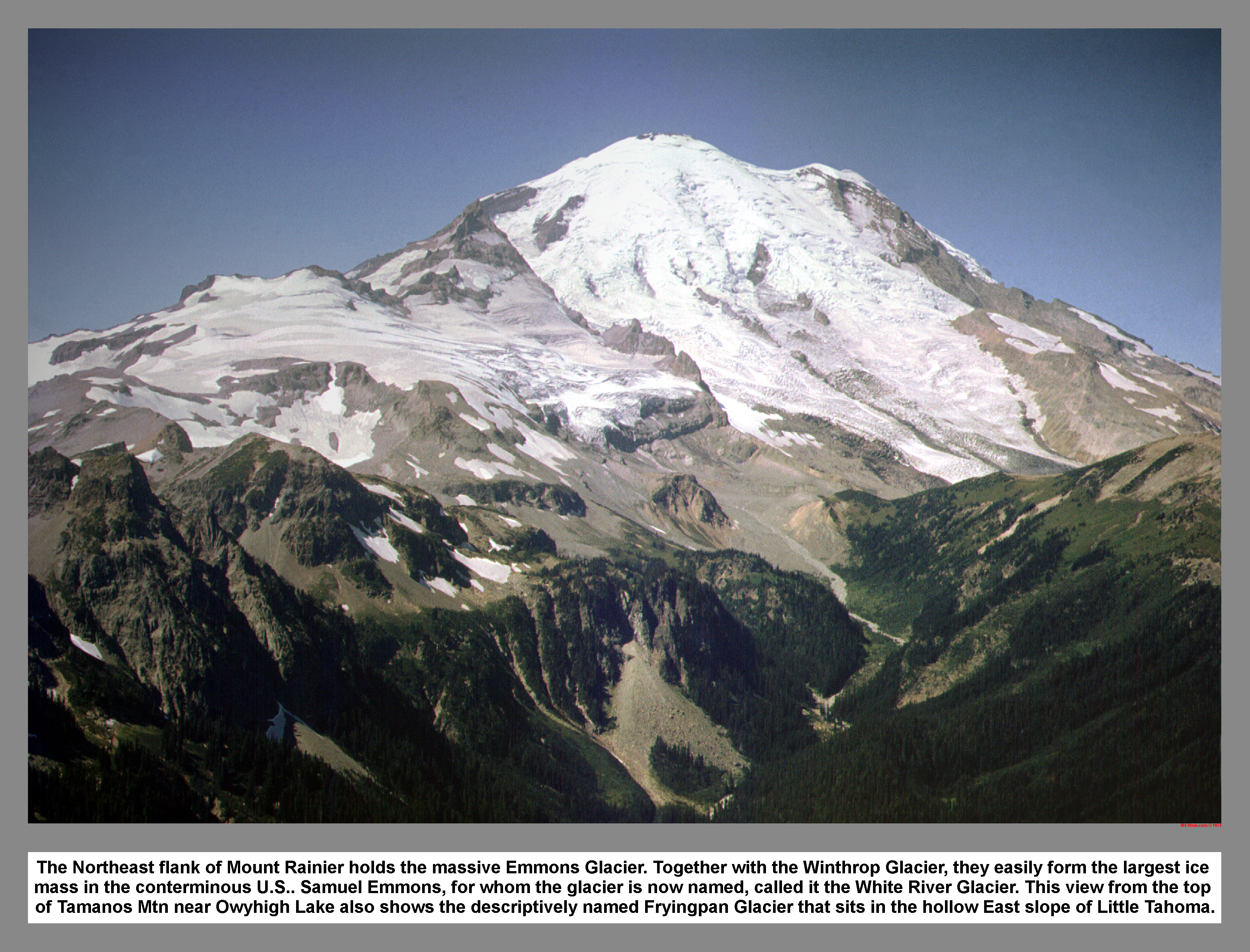
The massive hulk of Mount Rainer devoured all the space to the west. I traversed the rocky crest to the true summit of Tamanos Mountain and then signed the summit register. I gawked at the view for more than a hour before starting down. Instead of dropping back down to the lake, I went down the crest of the south ridge, and climbed on some very sound rock. I bypassed a few exposed places on the east. As I returned to the crest after bypassing one airy monolith, my curiosity was aroused by what sounded like a group of people hammering two by fours on the rocks. I was relieved and surprised to find instead a herd of mountain goats, barely one hundred feet below me, down on the west side. I counted twenty eight goats of varying sizes. I watched for a long time and observed how they slowed beneath the shade of a tree and scampered stiff legged amongst the rocks. I was pleased to think that I was unnoticed.
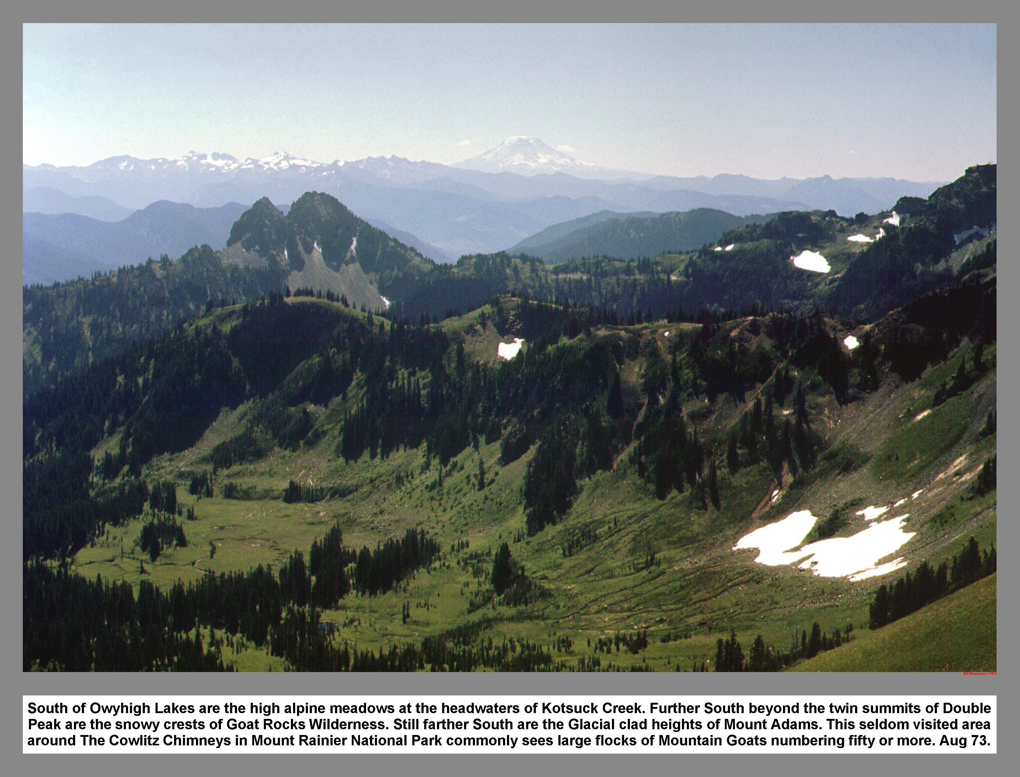
I climbed down the ridge toward the headwaters of Kotsuck Creek. I dropped down five hundred feet and crossed two snowfields. A goat trail led up the Kotsuck Creek - Needle Creek divide. I found the trail was well used as was evident by the numerous clumps of wool on the brush along the side of the trail. I climbed to the 5900 foot notch called Goat Pass. Hoof prints were everywhere in the pass.
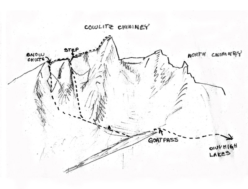
South of the pass and across the upper Needle Creek Basin, were the dark rocky stacks of the Cowlitz Chimneys. The more I studied the Cowlitz Chimneys for climbing routes, the harder and more strenuous they looked. Eventually I decided I would not make a solo attempt that day. I found the goat path down the south side, but I did not descend. I explored the divide and then had a smoke before I went back down.
I contoured upper Kotsuck Creek and met the trail at the 5300 foot divide above Owyhigh Lakes. When I reached the lakes, I found two other tents at the south end of the main lake. After arriving at my tent, I cooked and ate dinner. After eating, I took a walk around the lake. I sat down at the north end of the Lake and watched the sunset.
As I finish my smoke and was about to leave, a doe and a buck emerged from the tree line on the east side of the lake. The buck seemed very suspicious. However, finally, they both waded out into the shallow water to drink and graze on the tender shoots. I set my camera, but found that brush obscured the view. I slowly stood up to improve the view. But, I lost my balance and made a jerking movement to regain it. All the awkward stumbling quickly gave away my position and the startled deer fled toward the woods as I clicked the shutter. The neighbors camped across the lake laughed and applauded at my failed tactic.
As I walked back to camp, I admired the saw toothed spires that made up Governors Ridge. Back at camp, I crawled into my sleeping bag for the night and went to sleep.
In the morning, after sleeping-in, I ate a quick breakfast and struck camp. When I was all packed up, I left behind the wonders of Owyhigh Lakes and then strolled back down the seven switchbacks.
03 049 Mount Rainier at sunset from the top of Iron Mtn
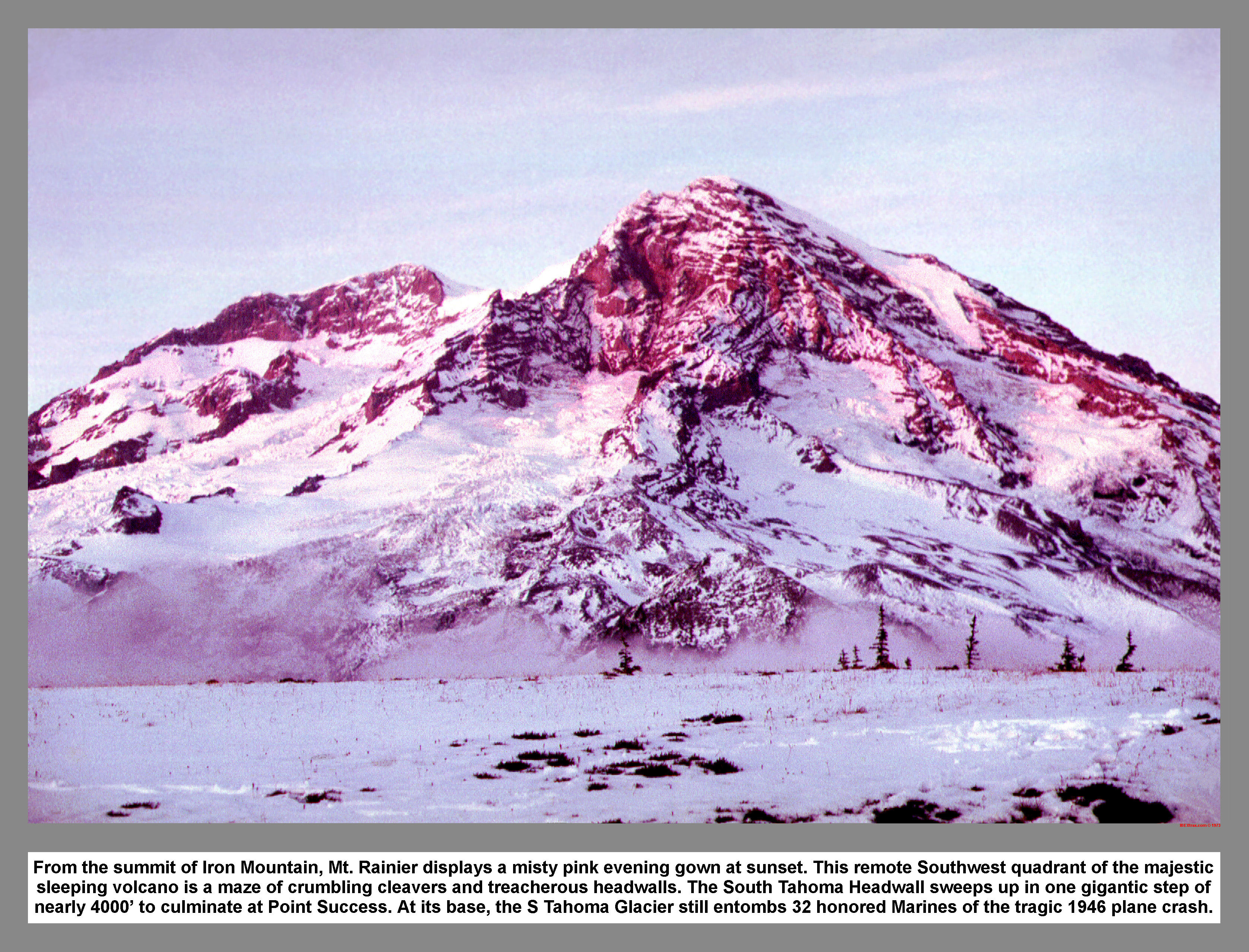
From the summit of Iron Mountain, Mt. Rainier displays a misty pink evening gown at sunset. This remote Southwest quadrant of the majestic sleeping volcano is a maze of crumbling cleavers and treacherous headwalls. The South Tahoma Headwall sweeps up in one gigantic step of nearly 4000' to culminate at Point Success. At its base, the S Tahoma Glacier still entombs 32 honored Marines of the tragic 1946 plane crash.
06 075 Mount Rainier From Sunrise Point
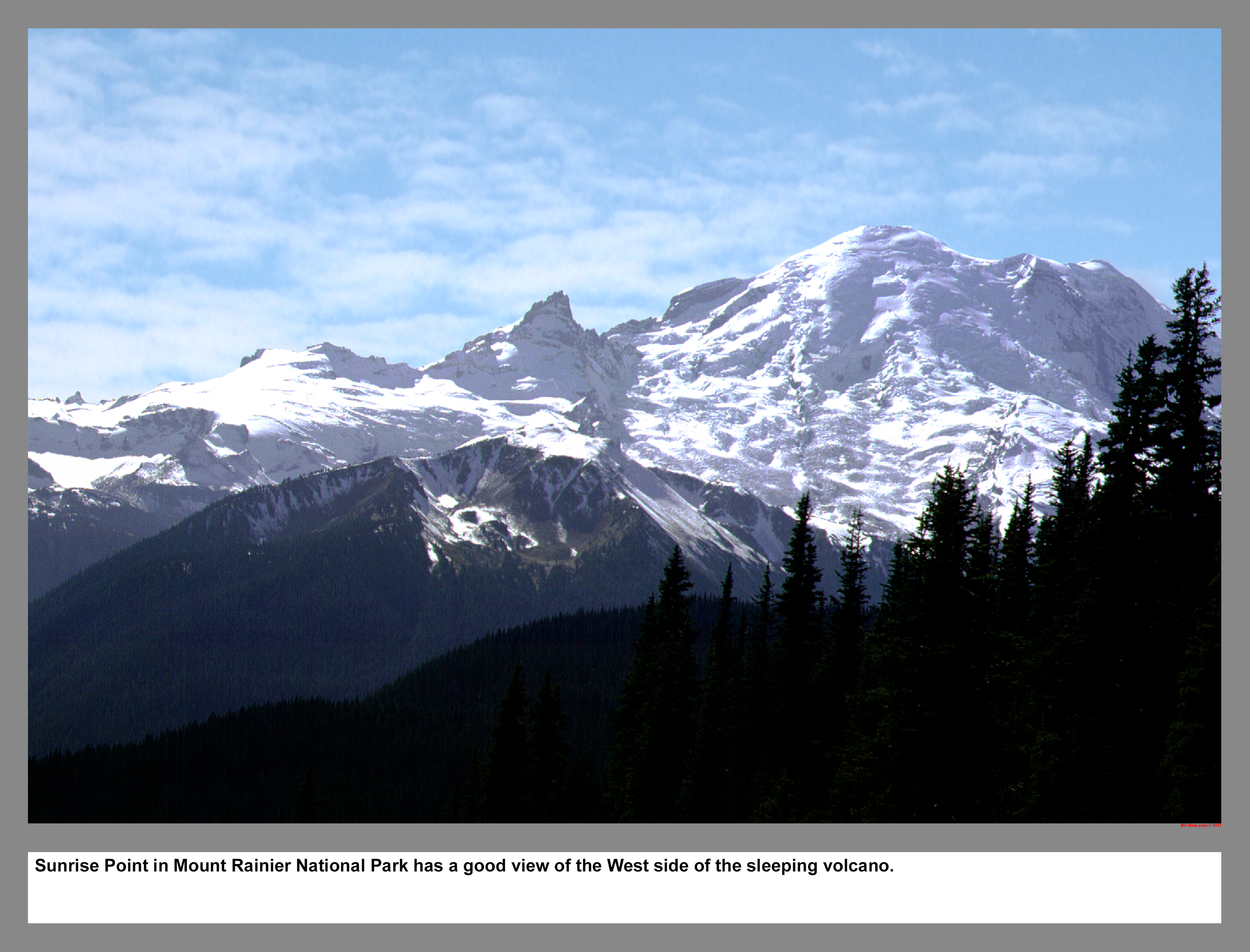
Sunrise Point in Mount Rainier National Park has a good view of the NorthWest side of the sleeping volcano. The road to Sunrise and Yakima Park closes every year after the first major snow accumulation.
|
|
|
|
|
|
This site created and maintained by THE IBEX - Page last revised:
|
|