
|
|
IBEXtrax.com - Cascade Mountains of Washington StateNorth Cascades Park |
|
|
The plan was made to take two days on the Mount Ross approach; spend the third night at Picket Pass, and the next three days in Luna Cirque. For the final three days, we planned to hike out through Ross Dam via the Luna Peak High route. To complete the loop, I recruited my parents to move John's car from Newhalem up to the Ross Dam trail head. After I made a hasty purchase of a cheap plastic ground tarp, we were ready.
John woke me Saturday morning, and then we left Goat Hill in sunny weather. The first stop came fifty miles up Interstate five at Burlington were we ate a large breakfast. The second stop was in Sedro Woolly were John bought an inexpensive watch. As we neared Marblemount, the excitement of the North Cascades increases. The view up the Cascade River toward Eldorado Peak looked delicious. At Marblemount Ranger Station, we picked up our backcountry permit, and then secured information on the Ross Dam exit. Just outside of Newhalem, we visually traced the route up Mount Ross before we drove on. We recorded the way to where we would park the car, before I called my dad to give him the information. After we asked a passing tourist for the time, we returned to the abandoned junkyard were I had parked the Pinto in 1975.
From the "parking lot", we walked around a fence and then started up the west ridge of Mount Ross. Soon after we started up the ridge, we were greeted by a small welcoming party of renegade mosquitoes. Things started to look up as we found animal trails that led up through the isolated cliffs. Instead of looping around on animal trails, we chose to climb a few of the short steps before we broke into the open forest of the upper ridge. The sun had climbed high behind a thin fail of cirrus clouds by the time we reached a deflector board. We followed a faint path up the ridge in the gathering bugs. When I showed John the water hole I had found in 1975, I notice the snow that hadn't been there the year before.
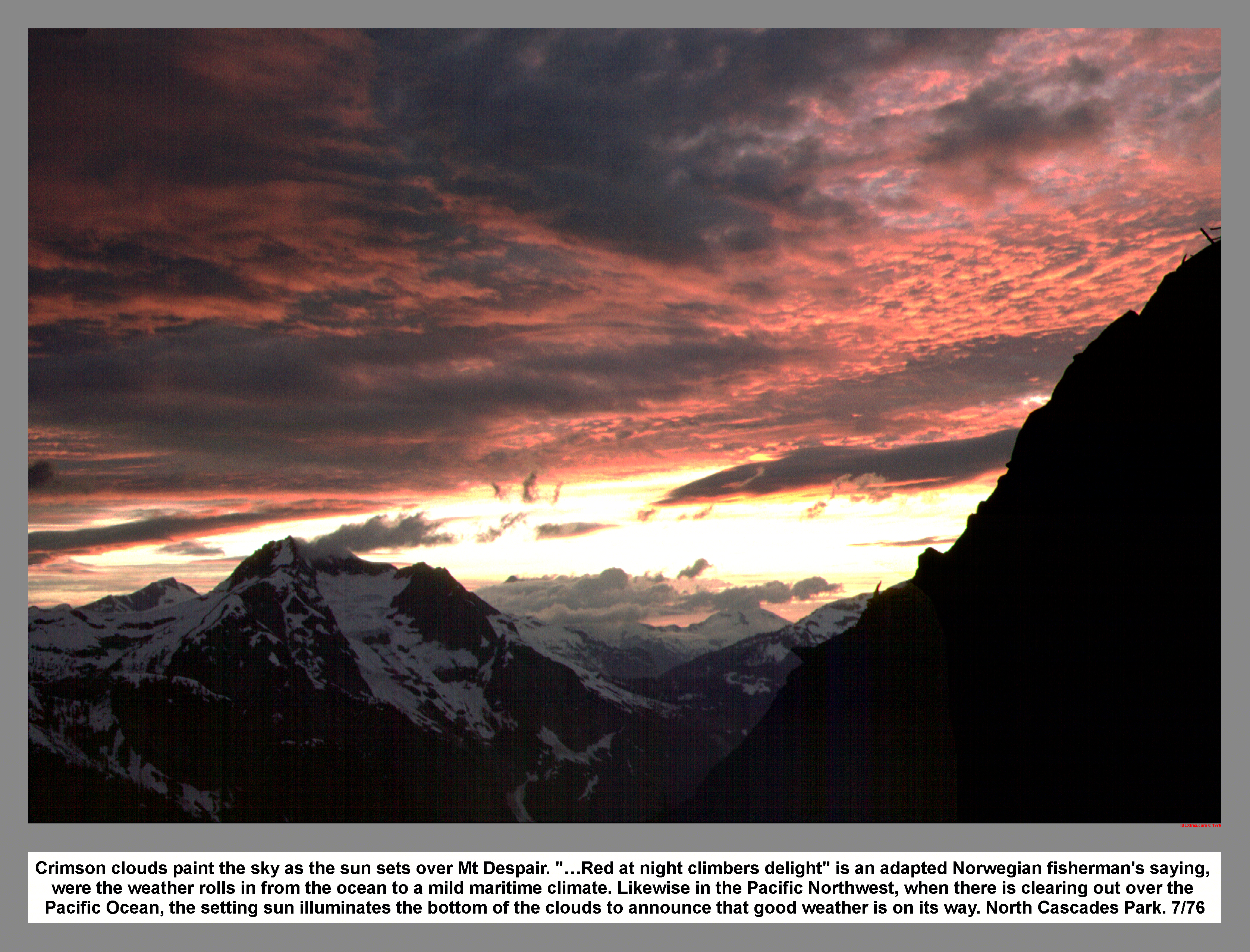 Further up the ridge, we stopped to rest on a wind blown rock. We sat in the wind to protect ourselves from the swarms of mosquitoes. However, between wind gusts we swatted the bugs off each other. Just before we reach the talus below the head wall, John spotted a deer in a vine maple thicket. We traversed below the head wall, and then followed an exposed ledge into the gully. There was some technical rock climbing on wet mossy rock were we entered the bottom of the gully. Half way up the gully, I stopped following John and moved right into a parallel gully. I was getting tired, so I slowed up and then John moved ahead. I caught up with John at the ridge crest where he was waiting. From the crest, we moved left on to the snow. After only a few steps on the snow, I felt my feet getting wet. "Let's find a flat spot to camp", I said. We chose a snow free alder thicket and then did some minor clearing before we stretched out the tarp. After John returned with water, I cooked dinner. The sunset turned into a breathtaking extravaganza of crimson shades and towering cumulus clouds. The threatening clouds were moving toward us. So, John and I snuggled into our sleeping bags and then waited for the storm to hit. The heavy rain started around midnight.
By morning the weather had turned into a foggy mist. After we ate one of John's breakfasts, we broke camp and then discovered the perforated ground tarp. We packed up and then headed north in low visibility. We traversed around the summit of Mount Ross on the highway size ledge that I had discovered the year before. The fog was pea soup thick when we gain the ridge north of Mount Ross. The plan was to follow the cornice. So, we moved north, traveling the fine line between visibility and snow collapse. We wanted to stay close enough to see the edge, but far enough away to keep from riding the cornice down the Gorge Creek side. The snow depth was much deeper than the year before. Huge snow drifts, up to twenty feet deep, rose out of the thick mist.
I knew we would have to drop down around Peak 6705 (The Roost). However, we stayed high too long and paid for it with steep down-climbing on loose wet rock. Back down on the snow, we traversed the cirque below Peak 6705 in a white out. Route finding was impossible. So, we took a mint tea break and waited for a break in the fog that never came. We traversed blindly around the cirque until I caught a glimpse of the cliffs above. I didn't like what I saw. We searched for a route to the ridge crest, until finally I started kicking steps straight up a steep snow slope. John eventually took over as we broke over the top. I tried to orient myself with the foggy view. John pulled out his compass and completely shattered my usually unflappable sense of direction. I said north was one way and the compass pointed the opposite way. I tried to take the easy way out by declaring that the compass was wrong. However, John stood firm on going back and heading north. I sat on my pack in the fog and slowly straighten out my mind. It took a while, but finally we started back along the ridge top heading north. We found and then followed some goat tracks, until I noticed a familiar landmark. The landmark was partially covered with snow. But, it was unmistakably the big flat rock I had rested on the year before. Now I felt confident that we were on the route as we traversed north on the snow. Still traveling in the thick fog, we crossed more snow and then a few moves on wet rock. Then it was back to following the dreaded cornice.
As he frequently looked at his compass, John would occasionally report that we were not going north. I concluded that we had to compensate for the magnetic deviation. I kept looking for the pass I had camped at in 1975. But, we only found two huge cornice drop offs that forced us to the left. Finally John reported, "You are heading south again."
"I give up. Lets camp here. When the sun sets the weather will clear." I said.
John went for water as I started digging a flat spot in the snow. I scooped-up balls of snow with a Tupperware bowl and then we used the snow balls to make walls. The shelter turned out to be very nice after setting the tarp over the top. As the sunset the fog rose slightly. I took a bearing on Pinnacle Peak before the fog settled back in. We used the bearing and the map to figure out our position. It felt good to get out of my boots, for they had been wet all day. I pour the water out of my boots and then rung out my socks. We ate beef stroganoff by candlelight before we went to sleep.
We slept in until some light filtered through the thick mist. John cooked one of his quick breakfasts. After eating, we packed and then returned to blindly following the cornice north in the fog. We found the pass, even though it was disguise by the huge snow pack. After finding my old camp site, We climbed Peak 7200+ (Glee Peak) by groping up through the fog. On the summit, the wind was driving the mist horizontally. So, we sat in the lee of the summit rocks and ate granola bars. There was no view from the top of Peak 7200+.
The descent was made via the northeast ridge, and from there, we drop down on to the snow. As we climbed up around a rock buttress, the wind increased with the altitude. We climbed up rock and heather clumps to the leeward side of the ridge. When we reached a rock wall, John jumped the moat and then stood on top of a massive detached block of snow. I thought it looked like a serac and then I decided, "This is not the way. Let's go back around". We climbed back down to the snow, and then passed around another rock buttress. The sun almost burnt through the fog as we neared the cornice. I could not see it, but I knew the cornice was there. I could feel the danger on the back of my neck. Because the ridge top was flat, I didn't see the cornice until I was on the brink. I gasped to see over 2,000 feet below, and almost straight down, snow covered Azure Lake. I jumped back against a short gust of wind driven rain. We followed the cornice, at a respectable distance, down toward the pass. We passed what I thought was the pass until we passed another pass. When we pass the third pass, the weather had increased to a heavy wind driven rain. I pulled my arm up into the sleeve of my Anorak as we climbed the snow slope north of the pass. It seemed like a long trudge in the low visibility as we climbed up snow, and then rock, and then more snow. In a great stroke of good luck, the clouds broke momentarily and then showed us the way to "the gate" that led to the McMillan Spires bivouac ledge. We made a B-line for "the gate" by traversing a steep snow slope before we could pass through the notch and step out of the wind.
We sat down on the snow cover ledge and then boiled water for hot soup and sweet mint tea. After we drank the warming fluid, John chopped his way up a moat to the ridge top. The black summits of the Terror Group held the clouds back like a big picket fence, and thus revealing the rugged terrain of McMillan Cirque. Instead of testing the questionable cornice that hung from the east ridge of McMillan Spires, we drop down to the small evergreens and ledges of heather on the Azure Lake side of the ridge. On the traverse to Azure Pass, there was an unusual amount of scrambling on tree holds, and tedious exposed free climbing. John and I agreed that the Chimney Rock climb was good conditioning for the exposure we found east of McMillan Spires. We turned off the ridge just before reaching Azure Pass, and then descended the steep snow with a combination of control plunges and wild speed greedy sliding. As we quickly moved through a few small crevasses, the sun dropped behind Picket Pass.
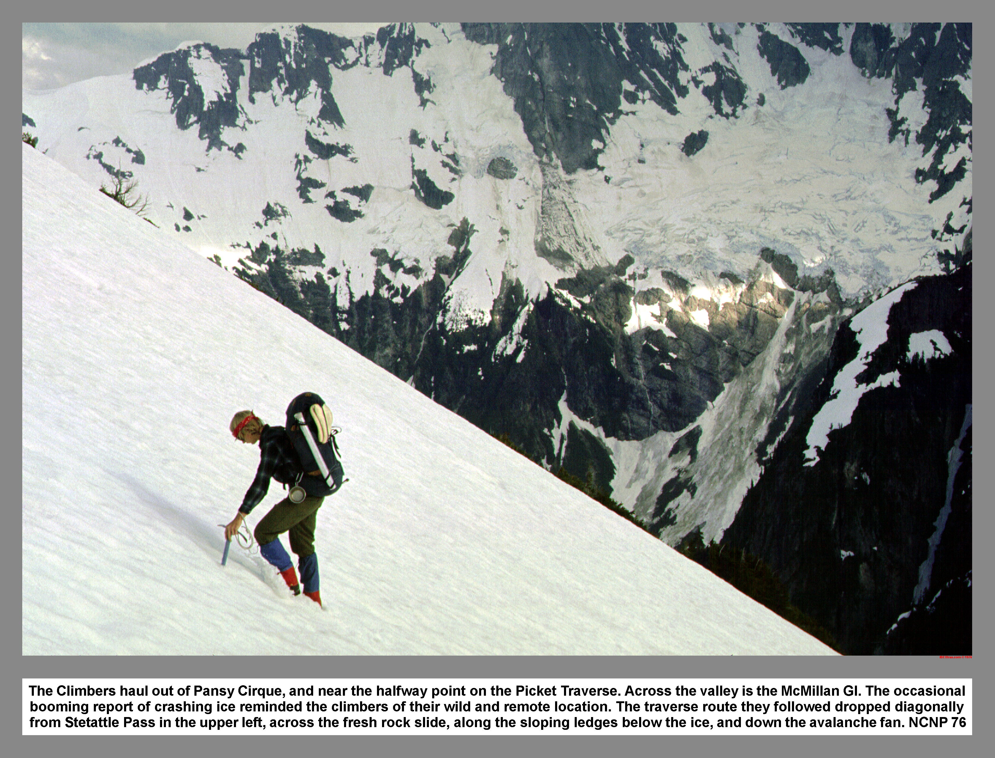
We traversed down past some well packed avalanche tracks, and then it was time to rope up and respect the big crevasses. We jumped one small crevasse and then looped around a large crevasse before we unroped. After the rope was stowed, we crossed another avalanche track and then entered an area of fresh rock fall. Many yards of dark rock had recently fallen off the north buttress of east McMillan Spire. The landslide left a giant, light colored, fresh rock scar on the north face of the spire. We crossed over a raging torrent on the bridge of hard snow, and then continued down on ice polished rock. We searched for the key ledge described in the Tabor-Crowder guide. We used the crab walk to scramble down the polished slabs. The decision on, "Which ledge do we take?" was expedited due to the impending darkness. While we hurried down in the failing light, I lost my footing and then my feet flew out from under me. I slowly pick myself up from the wet before we continue down into the darkness. By the time I discovered we had picked the wrong ledge, it was too dark to go back up and around. So, we rigged a repel and then repelled off with our headlamps glowing. After we reached the snow, I pulled the rope thorough and brought down a shower of rocks. Luckily we both walked away unhurt, and then headed down in search of a campsite. We followed the light from headlamps, down an ice block strewn avalanche fan. I tried to fight off the ominous presents of the ice that I knew hung above us. But, my senses were still very tense as we picked our way down through the fresh blocks of ice. We passed between some slide alder and then picked a campsite below a large alder patch. It took some digging to level the snow and a couple of sturdy alder poles to make camp. After dinner, I wrung out my sopping socks and then crawled into my wet sleeping bag. The camp was loud with the multi tone roar of cascading water. But, I was way too exhausted to keep from sleeping. However, with a gesture of local supremacy, the mischievous McMillan Cirque sat me up straight with a thundering echo of falling ice.
 The morning dawned bright and sunny. So, we threw back the dew covered tarp and then had a lengthy drying out session. We made a route change decision over breakfast. The new plan was to forgo the climb to Picket Pass, and instead follow the more direct route to Luna Cirque.
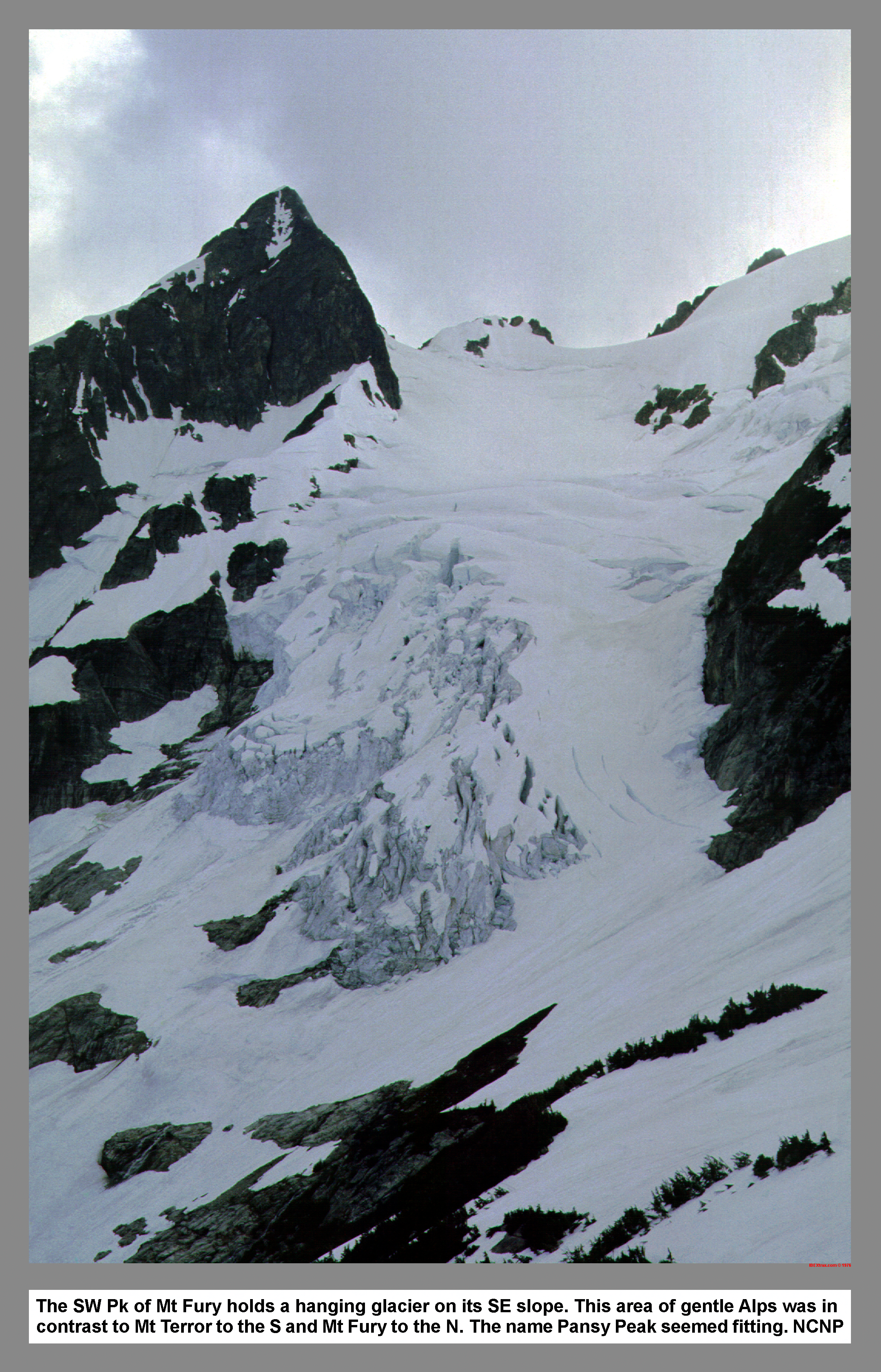
 After we packed, we went down the valley to check out the small cirque to the north. From a distance, we picked a route up the nearside wooded ridge. But, after we had a short spat with some brush, and got a closer look, we discovered a convenient snow gully that led up into the cirque. The snow filled slot opened up into a large snow covered cirque. As we hiked across the floor of the cirque, there was some ice fall from the glacier that hung on the side of Peak 7360+. We decided to call the cirque Pansy Cirque in contrast with Mount Fury and Mount Terror.
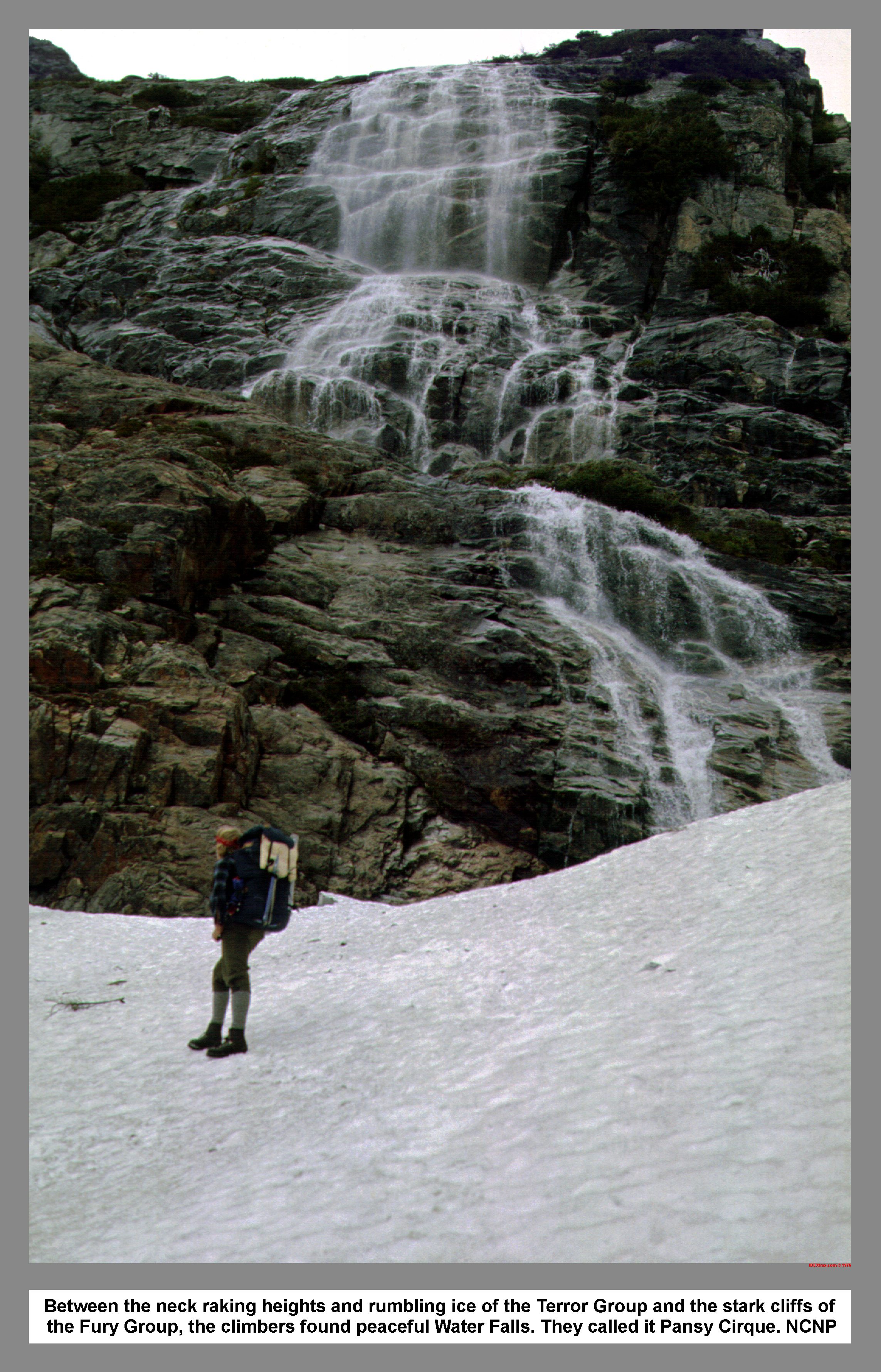 When we reach the spectacular water fall that dropped over the head wall, a short sprinkle of rain prompted a rest stop.
 By the time we had pulled out our rain gear, the rain had stopped. Our route went up to the right of the falls; climbing through small trees and up steep rock. We had to move left to pass a section of wet rock before we broke out onto the upper slopes. As we climbed a B-line up the snow, the sun and cloud shadows drift their checkerboard pattern across the Southern Picket Range. As the day wore on, my steps became smaller. John and I exchanged the lead in the softening snow. We finally reach the ridge line nearly 4,000 feet above our McMillan Cirque camp.
 After climbing 500 more feet, we reached the top of Peak 7280+ and then took in our first view of Luna Cirque.
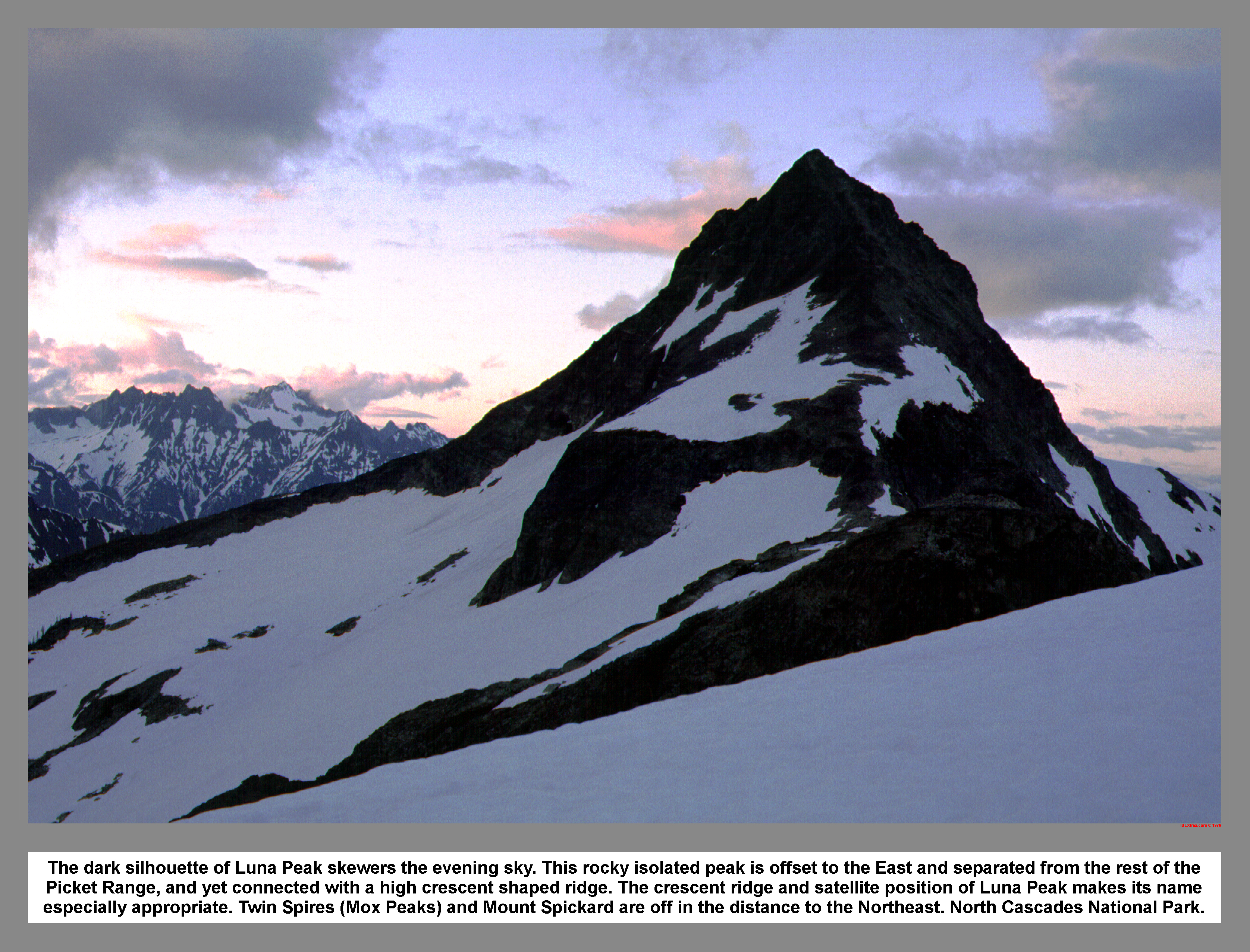
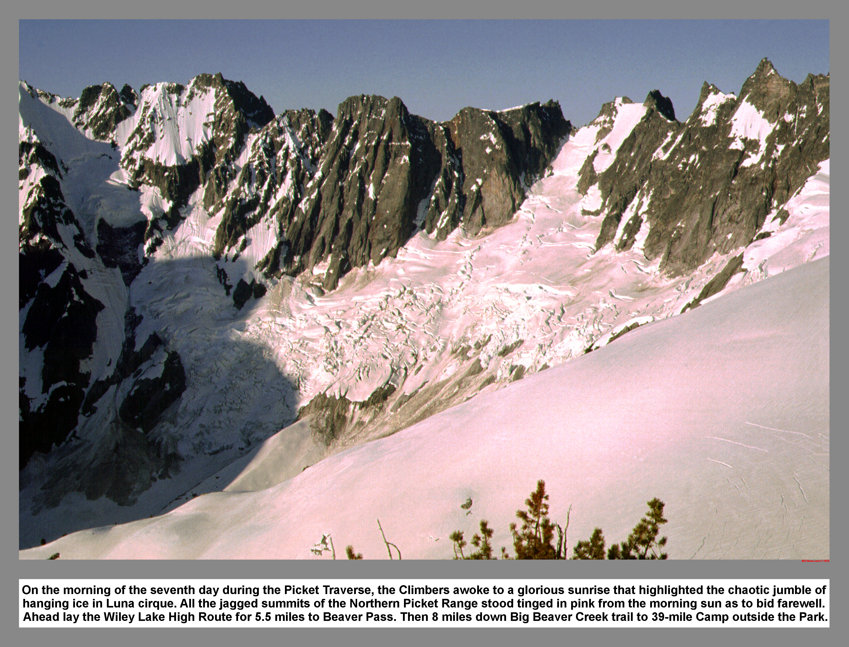
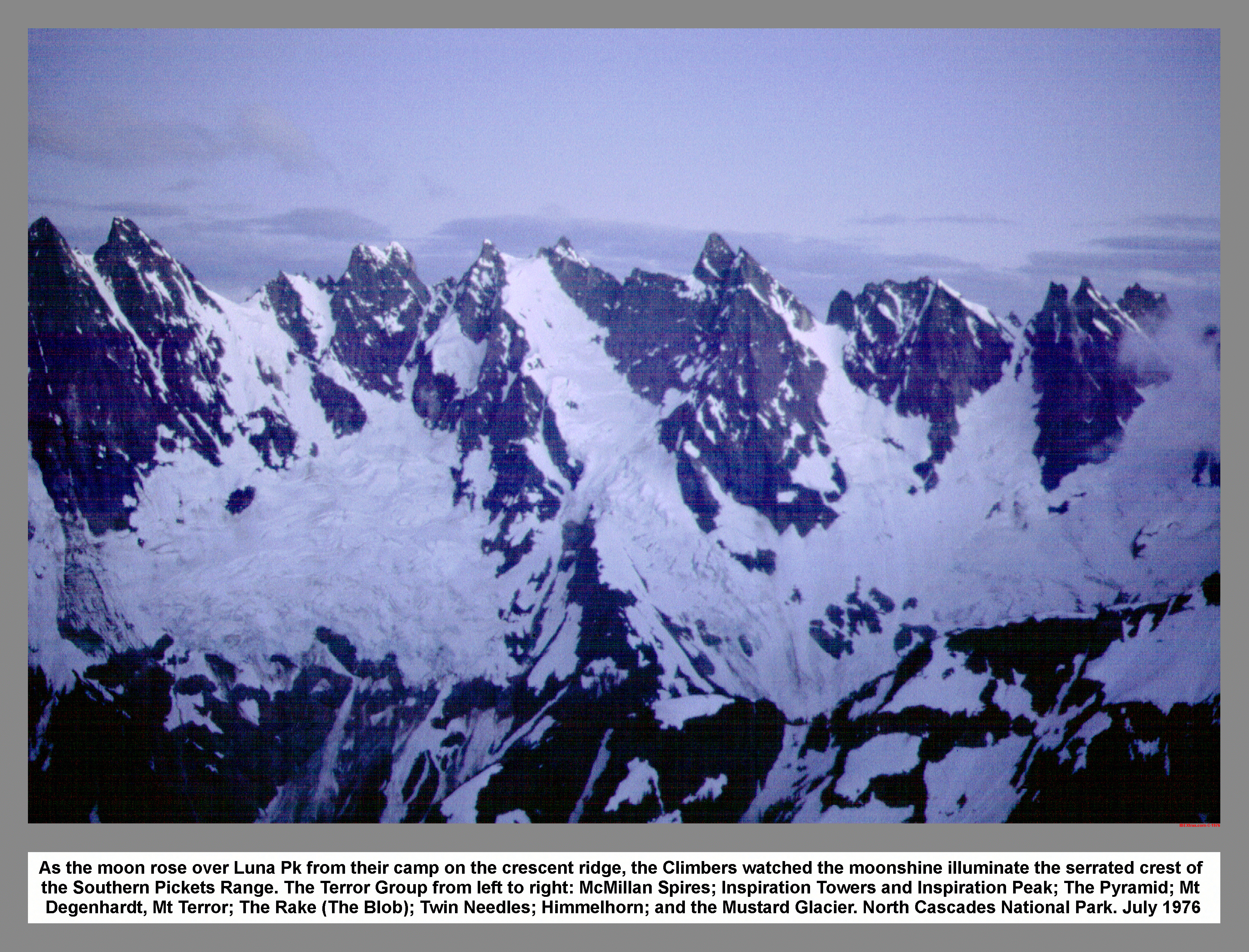 I felt enchanted to think that it had only been 40 years before, that Bill Cox and Will F Thompson recorded the first visit to this area. Some wispy clouds hung on the summit of Mount Challenger; adding to the mystique of our intended goal. John and I dropped down to the plateau that sat on the west side of Peak 7360+. We picked a tarp spot on the Crescent Ridge between Mount Fury and Luna Peak, and then set the tarp using a four foot cairn that we built. The sunset over the Black Tusk as the evening meal was prepared. Soon after sunset the clouds disappeared and then revealed the moonlit peaks of both McMillan and Luna Cirques. We decided to climb Luna Peak tomorrow. During the night, a sometimes gusty wind, snapped me awake with the thought of the teetering rock pile above my head.
 It was a cloudless Sunday morning. So, we had another drying out session.
 John and I smeared on a heavy coat of Pre-Sun before we broke camp. We shouldered our packs and then scramble down to the pass that sat just west of camp. When we passed through a shadowed area beneath Peak 7308, I briefly reconsidered the decision not to bring crampons on this trip. I carefully edged out across the hard slick snow. We both safely crossed the dangerous snow slope and then easily reached the top of Peak 7308 by following a wide spiral ledge. On the descent to Luna Pass we were blocked by a short cliff, so we resorted to rappelling. The rappel was tricky due to the vertical take off lip. We traversed snow across the pass, and then spread out our wet gear on a sunlit rock just north of Luna Pass. We left our gear on the "Dry-out" rock, and then headed for the summit of Luna Peak. Our route started up the west ridge. But we were forced right and then scrambled up the huge detached boulders on the south side. We huffed and puffed to the top of Luna Peak over broken rock. The best views were from the false summit (West Point). But we still traversed the summit ridge to attain the highest ground. Back on the West Point, we stayed awhile. I took some pictures. What a wondrous position we had obtained. A continuous panorama of the whole Picket Range was displayed before us.
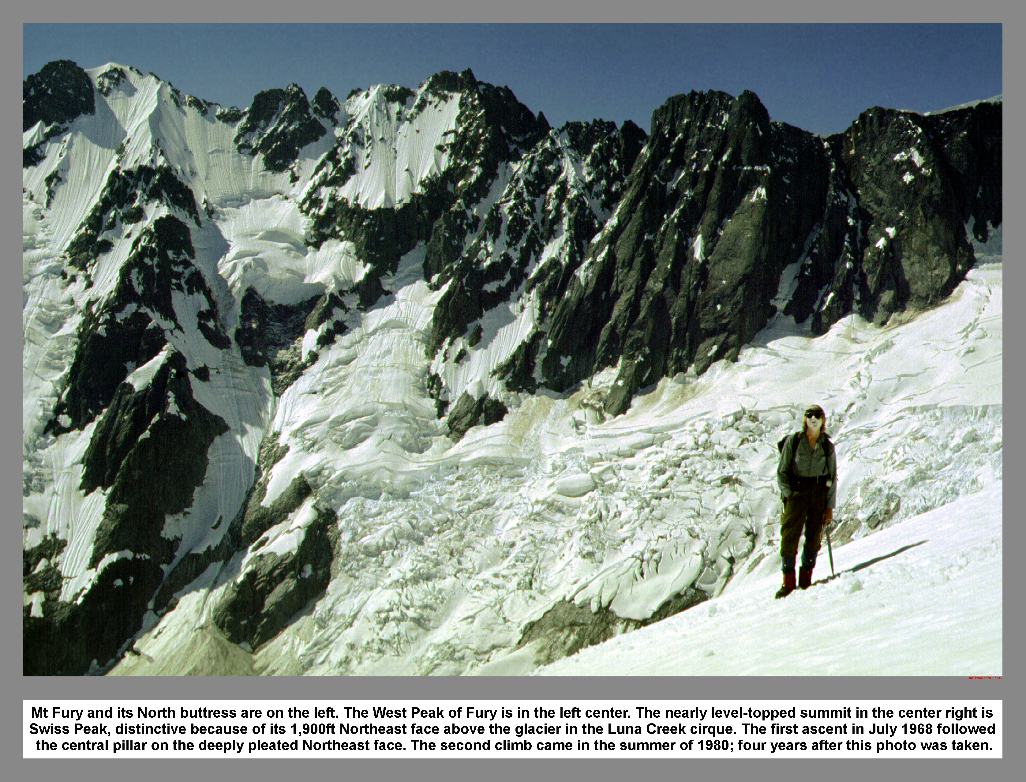
04 044 Crescent Ck Spires Mt Despair Pansy Pk
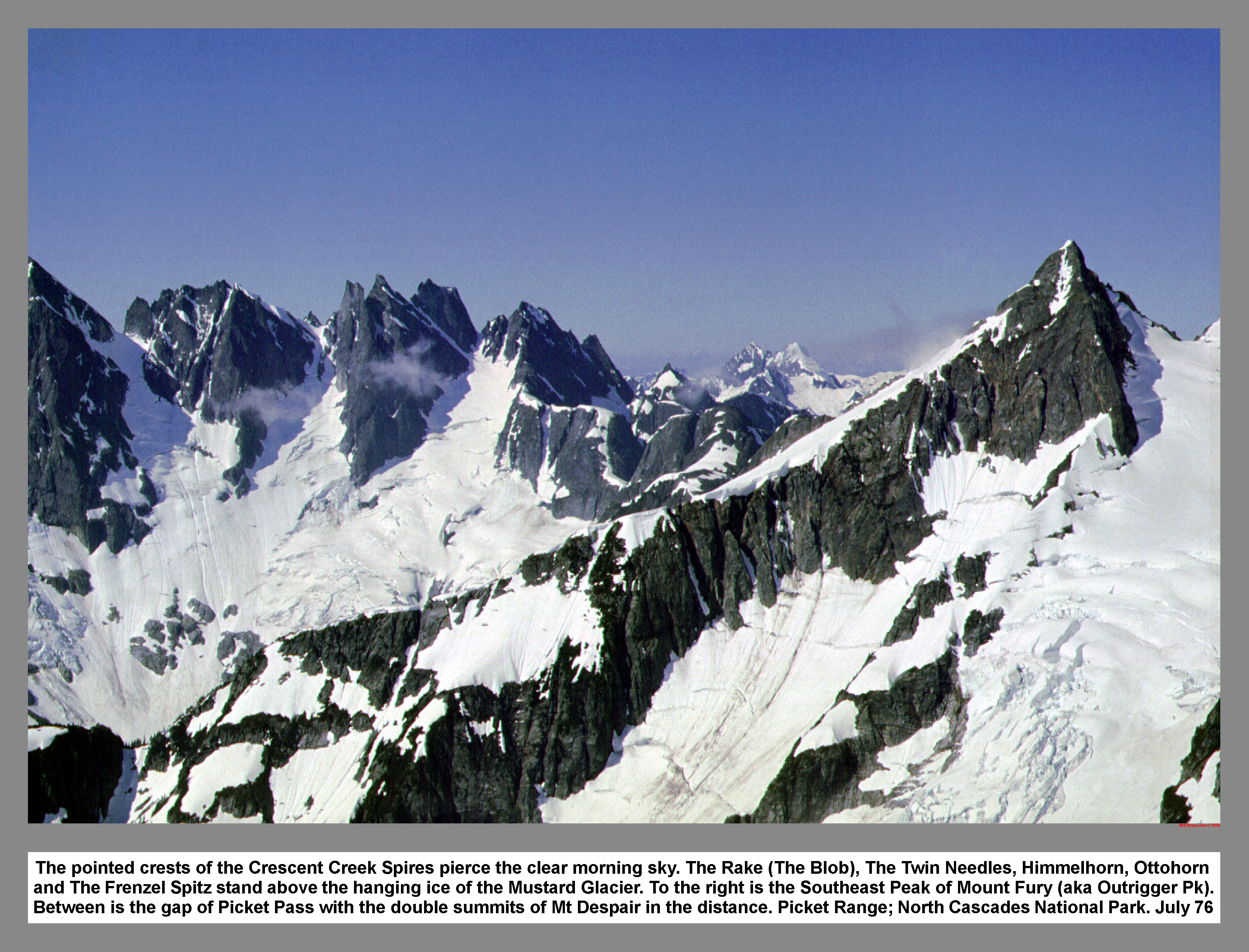
The pointed crests of the Crescent Creek Spires pierce the clear morning sky. The Rake (The Blob), The Twin Needles, Himmelhorn, Ottohorn and The Frenzel Spitz stand above the hanging ice of the Mustard Glacier. To the right is the Southeast Peak of Mount Fury (aka Outrigger Pk). Between is the gap of Picket Pass with the double summits of Mt Despair in the distance. Picket Range; North Cascades National Park. July 76
04 046 Crooked Thumb Mt Challenger Luna Cirque Gl
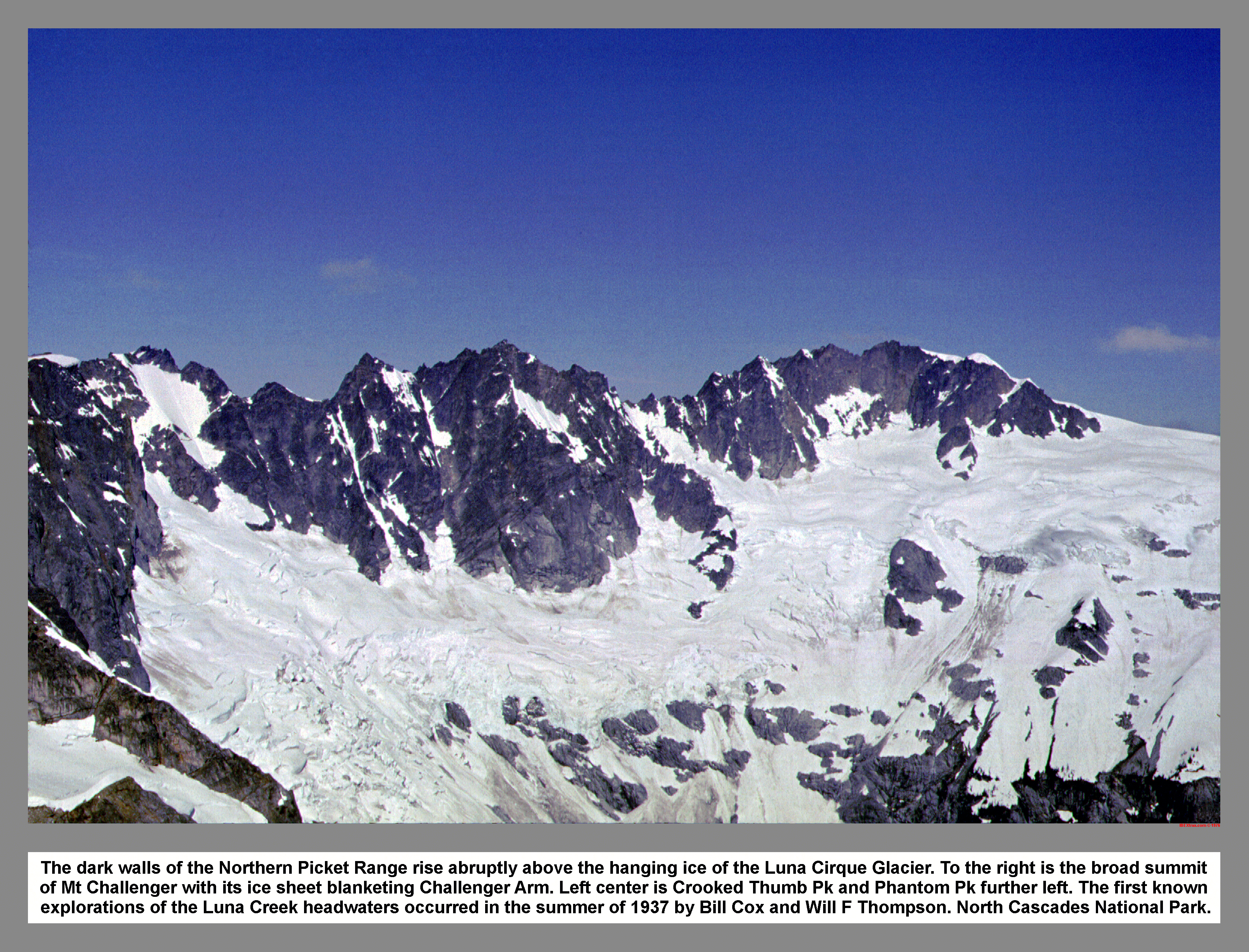
The dark walls of the Northern Picket Range rise abruptly above the hanging ice of the Luna Cirque Glacier. To the right is the broad summit of Mt Challenger with its ice sheet blanketing Challenger Arm. Left center is Crooked Thumb Pk and Phantom Pk further left. The first known explorations of the Luna Creek headwaters occurred in the summer of 1937 by Bill Cox and Will F Thompson. North Cascades National Park.
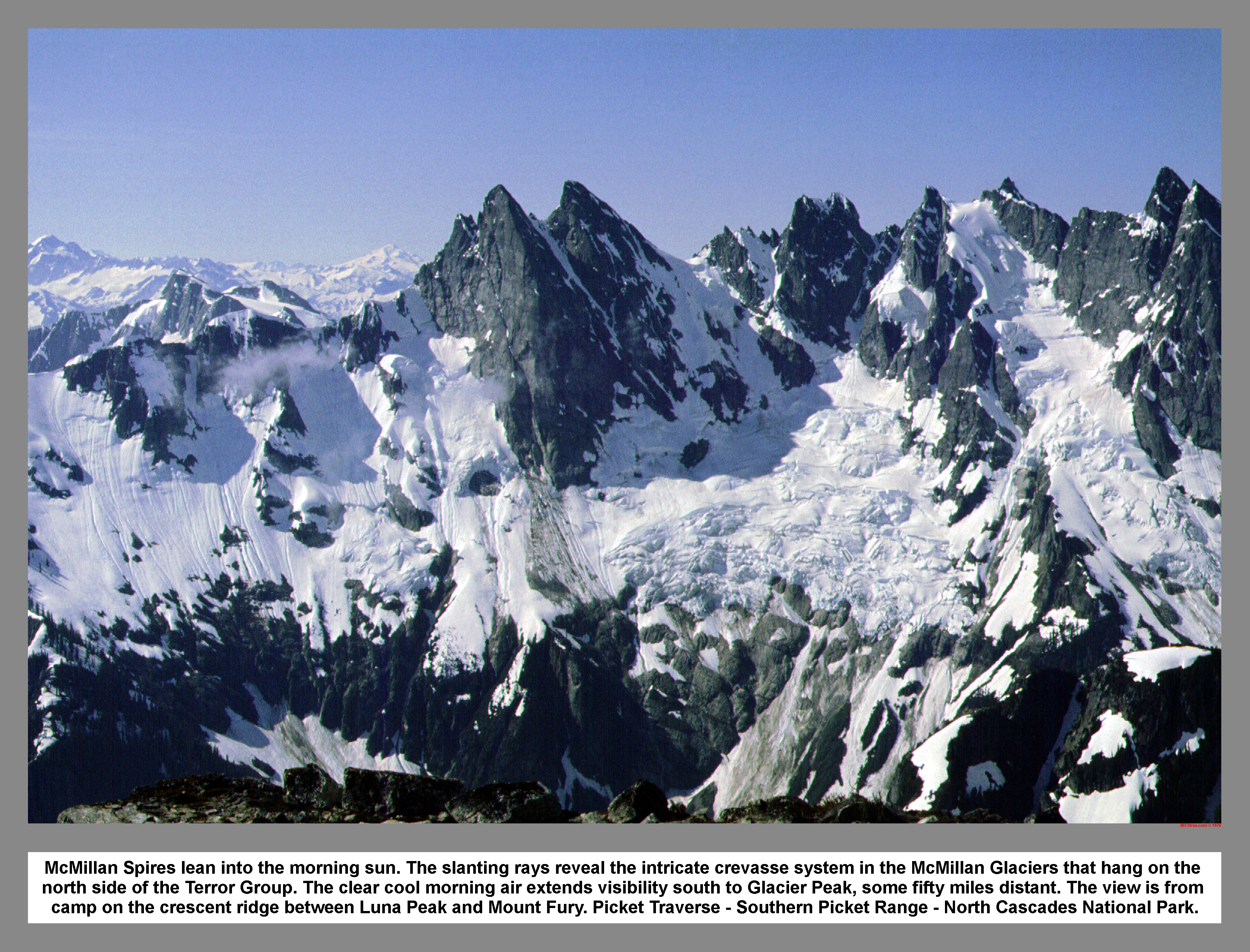
04 048 Picket Range Terror Grp McMillan Cirque P1
")
It is understandable why the Picket Range remained unexplored for so long, even on foot. Even the notoriously fearless prospectors made no claim to visits in this extremely rugged area. It was not until 1963 that the first recorded alpine traverse was made of the Picket Range when Alex Bertulis and Half Zantop came in from the south on a harrowing 10-day trek. Southern Picket Range; North Cascades National Park. 7/76
04 049 Picket Range from Luna Pk Mt Fury Pan2
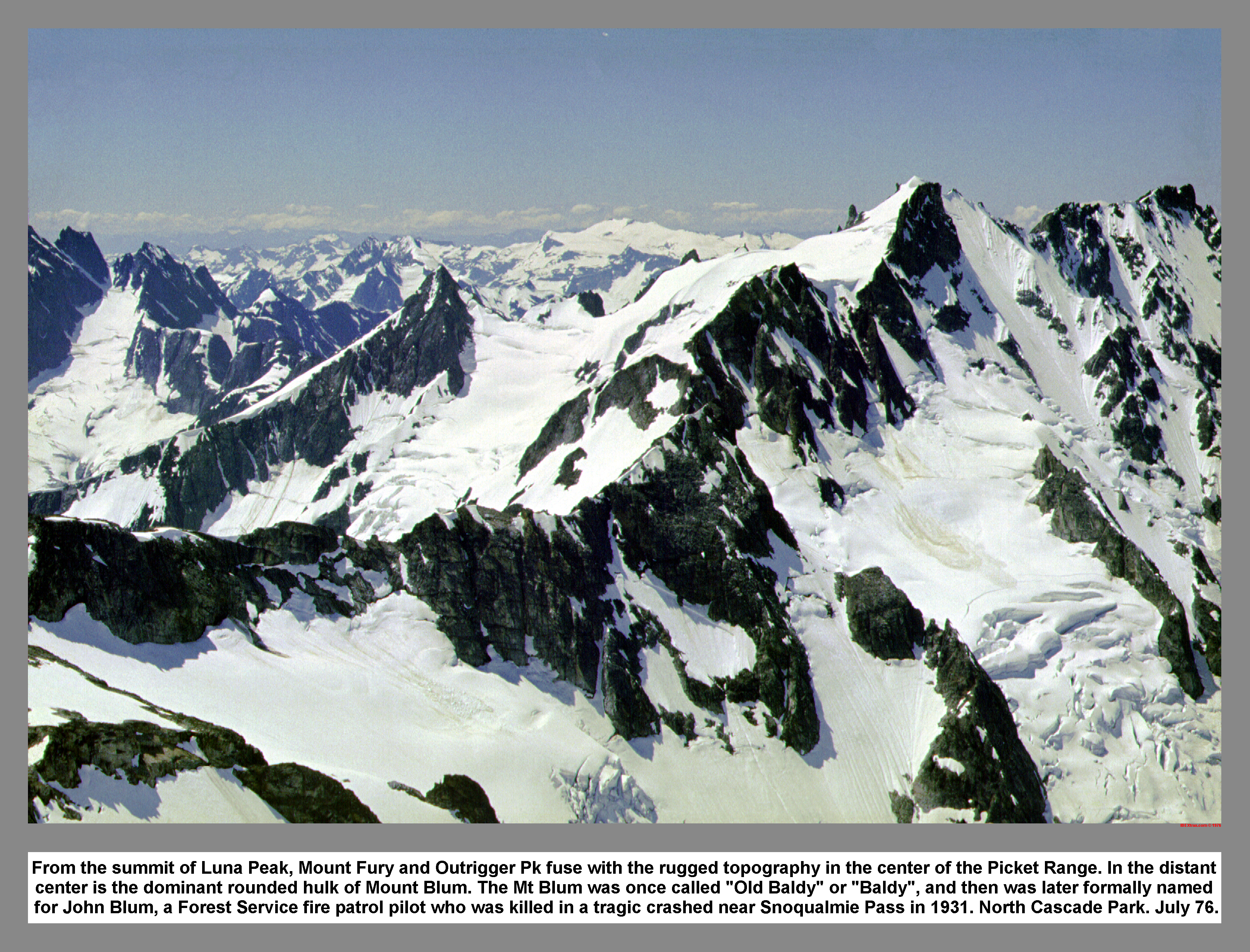
From the summit of Luna Peak, Mount Fury and Outrigger Pk fuse with the rugged topography in the center of the Picket Range. In the distant center is the dominant rounded hulk of Mount Blum. The Mt Blum was once called "Old Baldy" or "Baldy", and then was later formally named for John Blum, a Forest Service fire patrol pilot who was killed in a tragic crashed near Snoqualmie Pass in 1931. North Cascade Park. July 76.
04 050 Mt Baker and Mt Shuksan Luna Cirque Pan3
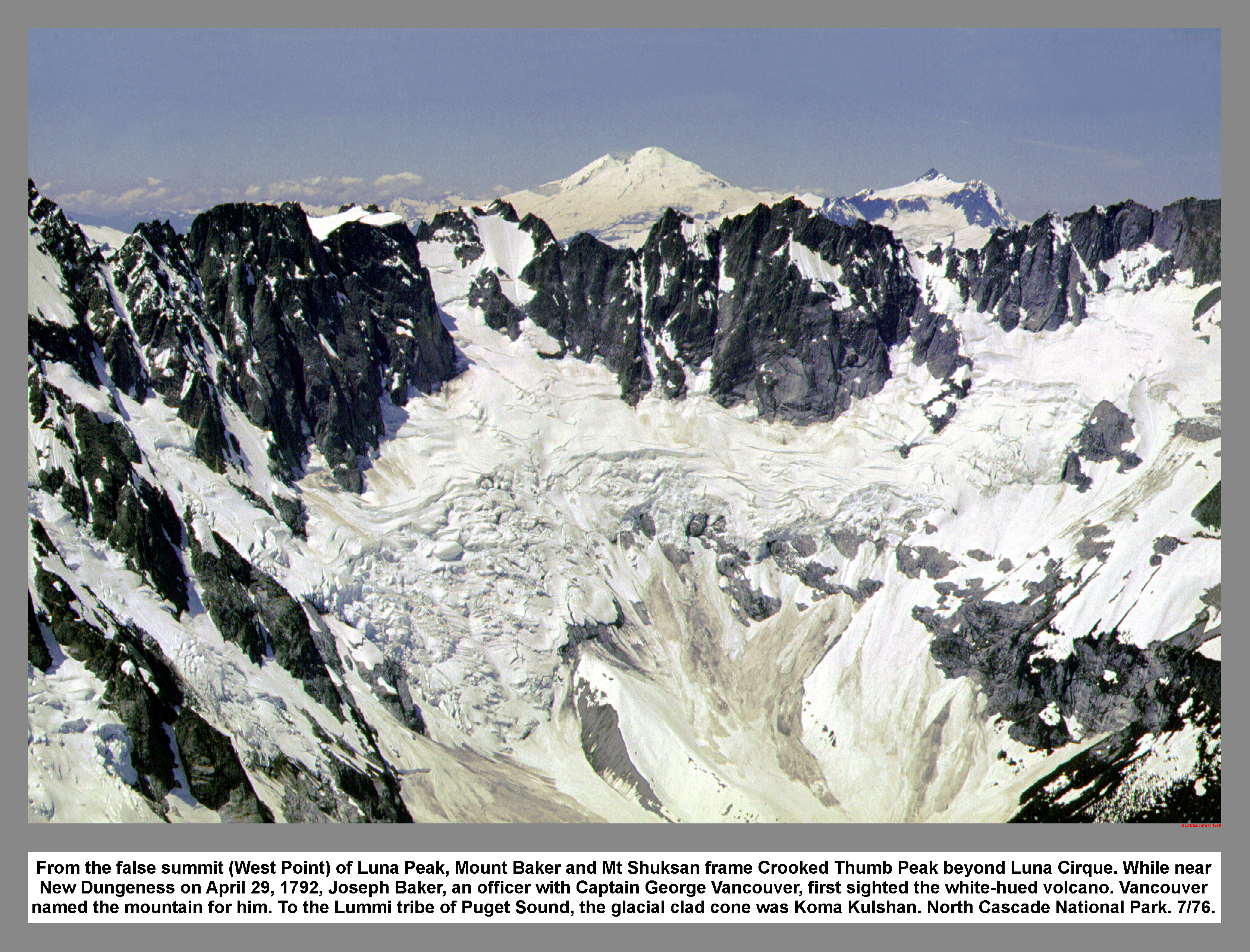
From the false summit (West Point) of Luna Peak, Mount Baker and Mt Shuksan frame Crooked Thumb Peak beyond Luna Cirque. While near New Dungeness on April 29, 1792, Joseph Baker, an officer with Captain George Vancouver, first sighted the white-hued volcano. Capt Vancouver named the mountain for him. To the Lummi tribe of Puget Sound, the glacial clad cone was Koma Kulshan. North Cascade National Park. 7/76.
04 051 Luna High Route Big Beaver and Jack's Mtn
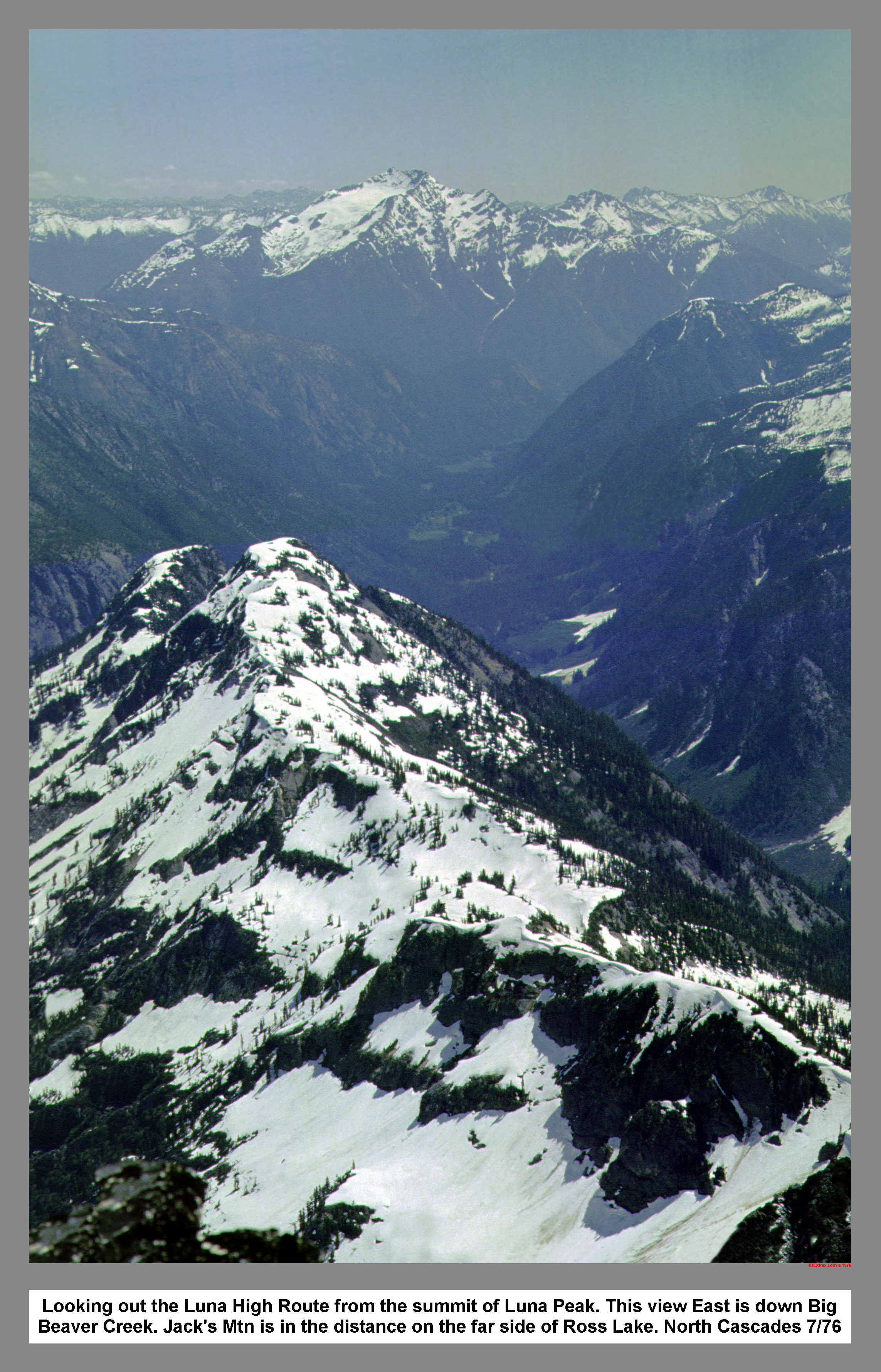
Looking out the Luna High Route from the summit of Luna Peak. This view East is down Big Beaver Creek. Jack's Mtn is in the distance on the far side of Ross Lake. North Cascades 7/76
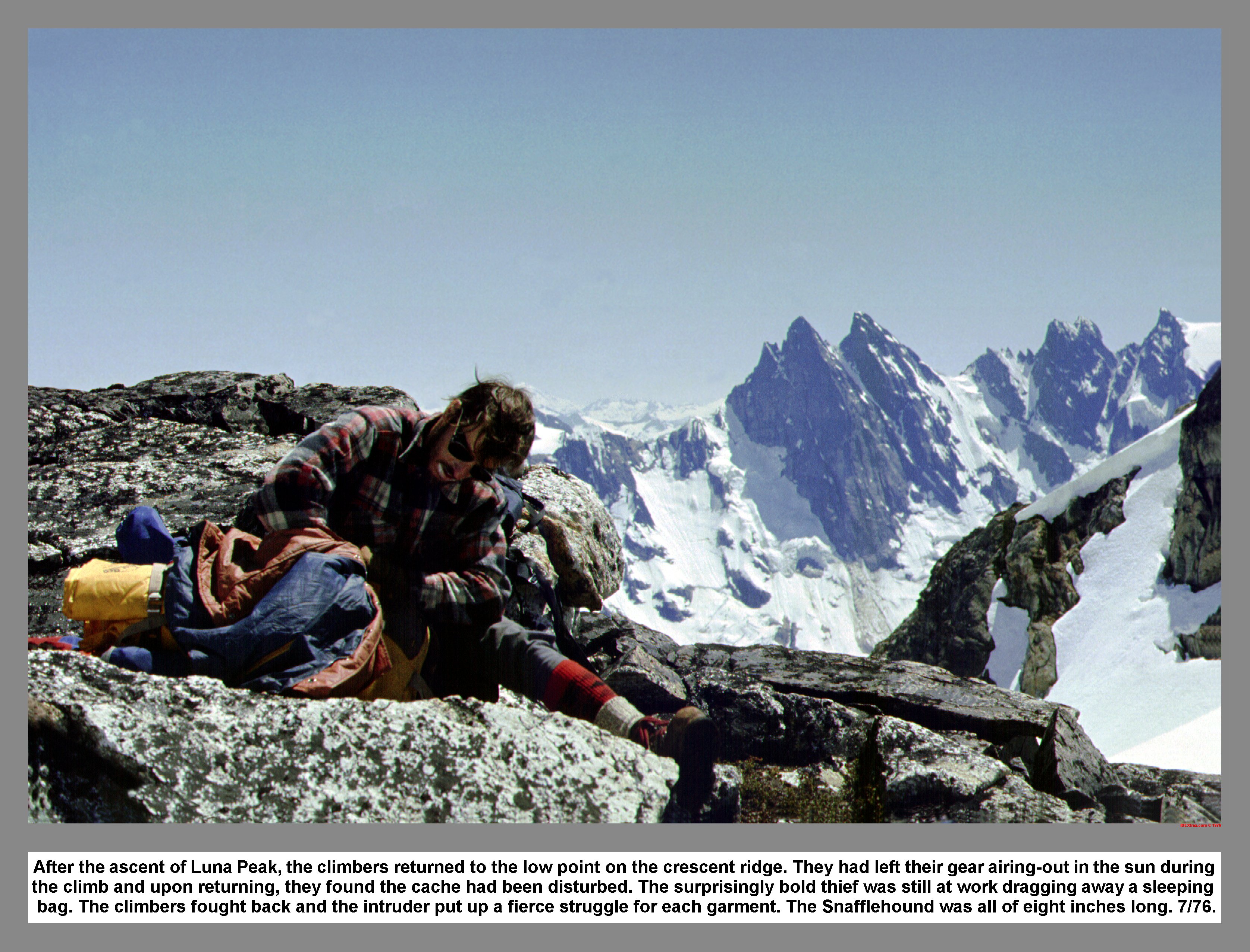 Eventually we scrambled back down to the "Dry-out" rock. While we were packing up our gear, a six inch, brown furry rodent scampered over and tried to swipe my sleeping bag. I thought it was a Pica at first. But, the fur was dark and the ears were different. We finally decided that it must be the now legendary Snaffle Hound described in Beckey's Challenge of the North Cascades. The bob tailed varmint tried to boldly snaffle my parka right off my lap and I had to swat at his ears to get him to let go. And then, as the stubby legged 'Hound scrambled between my legs, he set its little buck teeth into my sleeping bag again and then shook his head viciously like a playful dog. I tried and tried to capture the intriguing little beast on film. However, the camera shy thief got away before I could set up a good shot.
 Before John and I left Luna Pass,
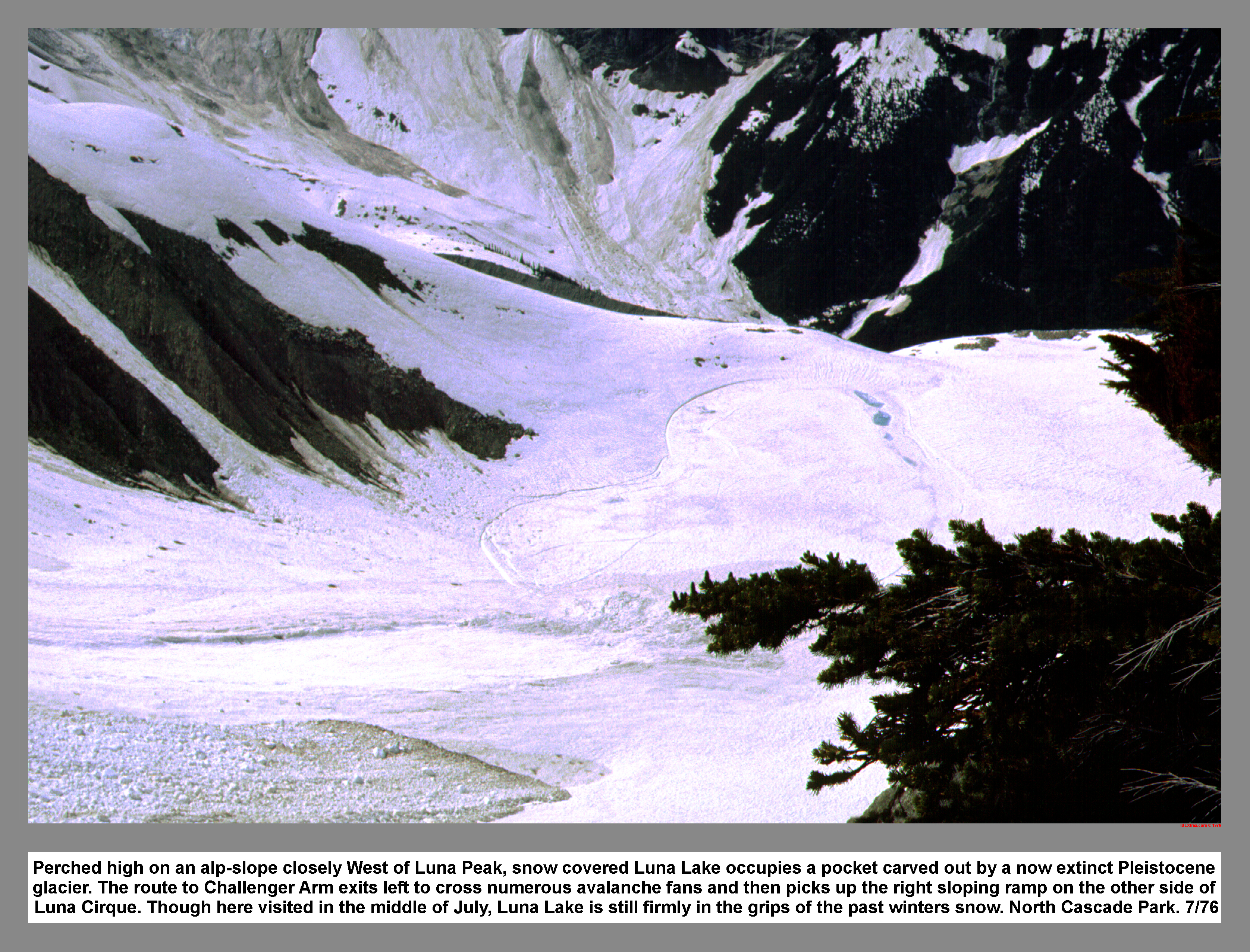 we visually traced out our intended route across Luna Cirque, and then surveyed the way up Challenger Arm. We then picked an alternate route just in case. We apply another coat of Clown White on our faces to combat the blinding sunshine. Then we started down in search of water. We use a standing glissade to descent toward Luna Lake. We took advantage of the first bubbling fountain of ice water and thoroughly quenched our thirsts. When we came to a cliff with a waterfall, we detoured left via a wooded ledge. After plunging and jogging down through some avalanche balls, we passed Luna Lake on the west side. I stretched out my stride and increase speed as John and I passed beneath the hanging ice on Mount Fury. The fast pace continued until we rested on the far side of the Lousy Lake moraine. The moraine is said to be one of the most perfect in the North Cascades.
04 056 Warren at Luna Falls glissade route (232k)
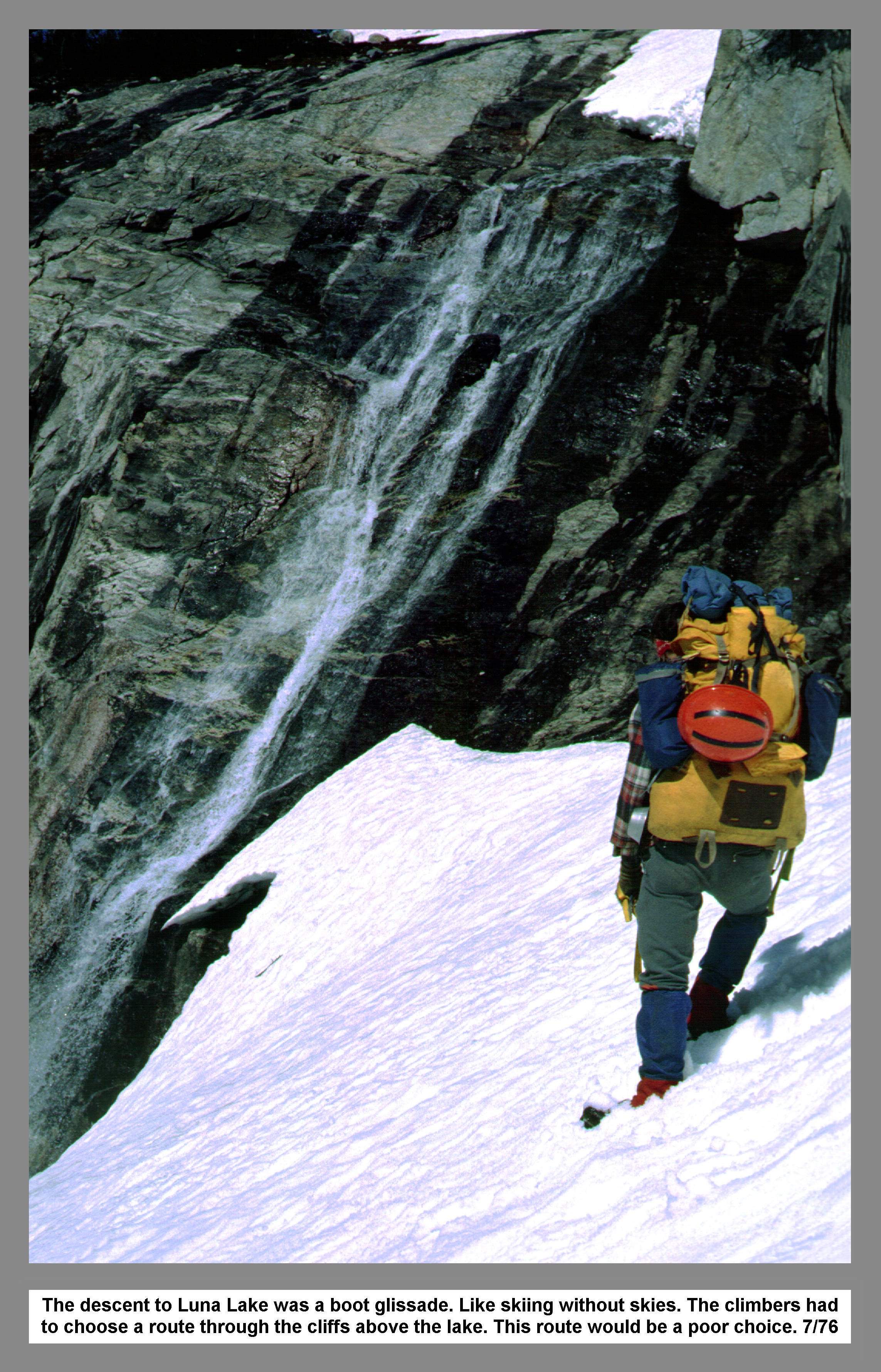
The descent to Luna Lake was a boot glissade. Like skiing without skies. The climbers had to choose the route through the cliffs above the lake. This route would be a poor choice. 7/76
04 058 Crooked Thumb Mt Challenger Luna Cirque
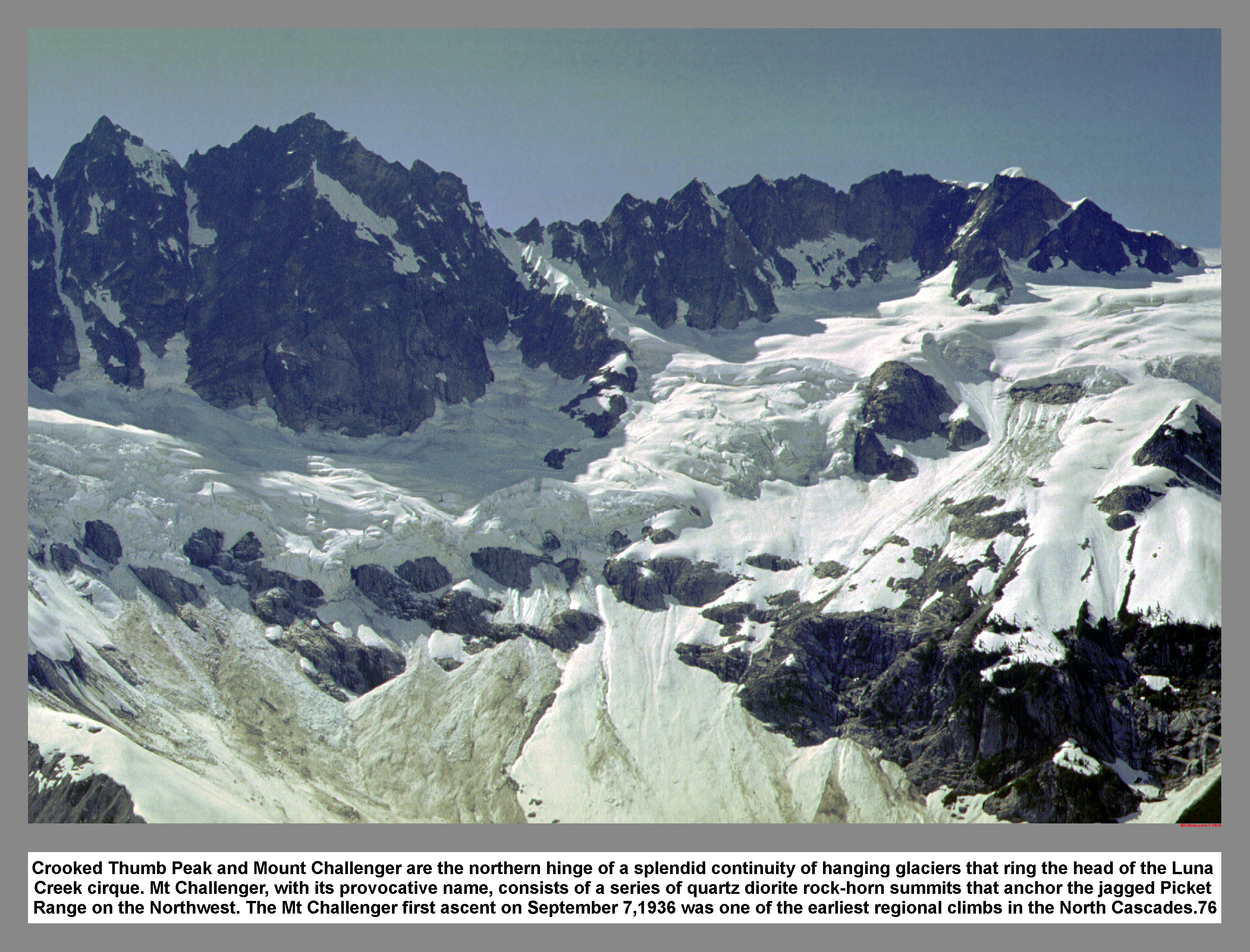
Crooked Thumb Peak and Mount Challenger are the northern hinge of a splendid continuity of hanging glaciers that ring the head of the Luna Creek cirque. Mt Challenger, with its provocative name, consists of a series of quartz diorite rock-horn summits that anchor the jagged Picket Range on the Northwest. The Mt Challenger first ascent on September 7,1936 was one of the earliest regional climbs in the North Cascades.76
04 059 Traversing below an Icefall John B
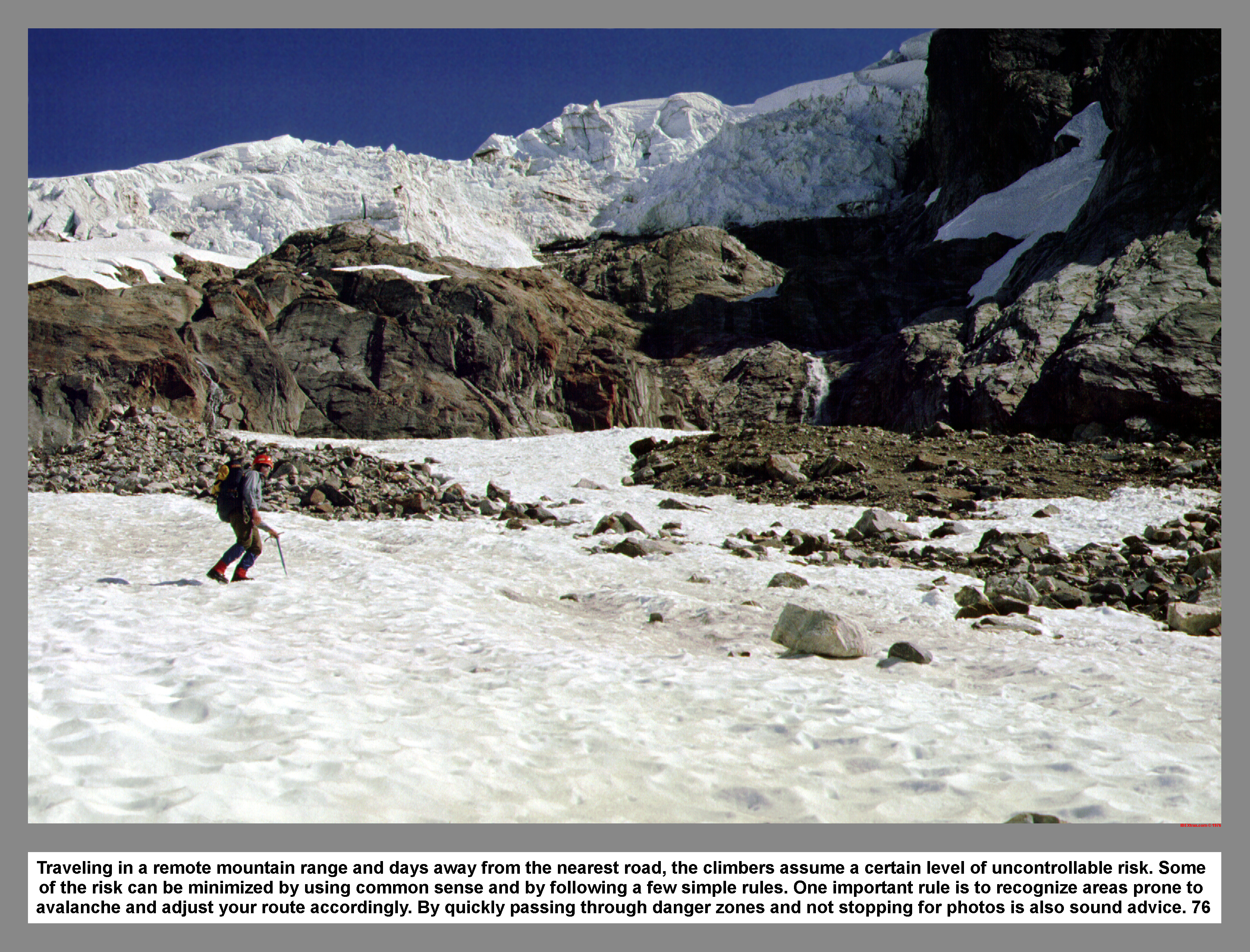
Traveling in a remote mountain range and days away from the nearest road, the climbers assume a certain level of uncontrollable risk. Some of the risk can be minimized by using common sense and by following a few simple rules. One important rule is to recognize areas prone to avalanche and adjust your route accordingly. By quickly passing through danger zones and not stopping for photos is also sound advice. 76
04 060 Lousy Lake is the source of Luna Ck

The very symmetrical nineteenth century moraine in Luna Cirque is said to be one of the most perfect in the North Cascades. The flattish area behind the moraine dam and above the small "Lousy Lake" is underlain by stagnant glacial ice. The ice is protected from melting by a layer of rock debris. In the distance at the foot of Luna Ck is Mount Prophet. It is named for early prospector and religious fanatic Tommy Rowland. 76
04 061 Mt Fury with crevasses of Luna Glacier
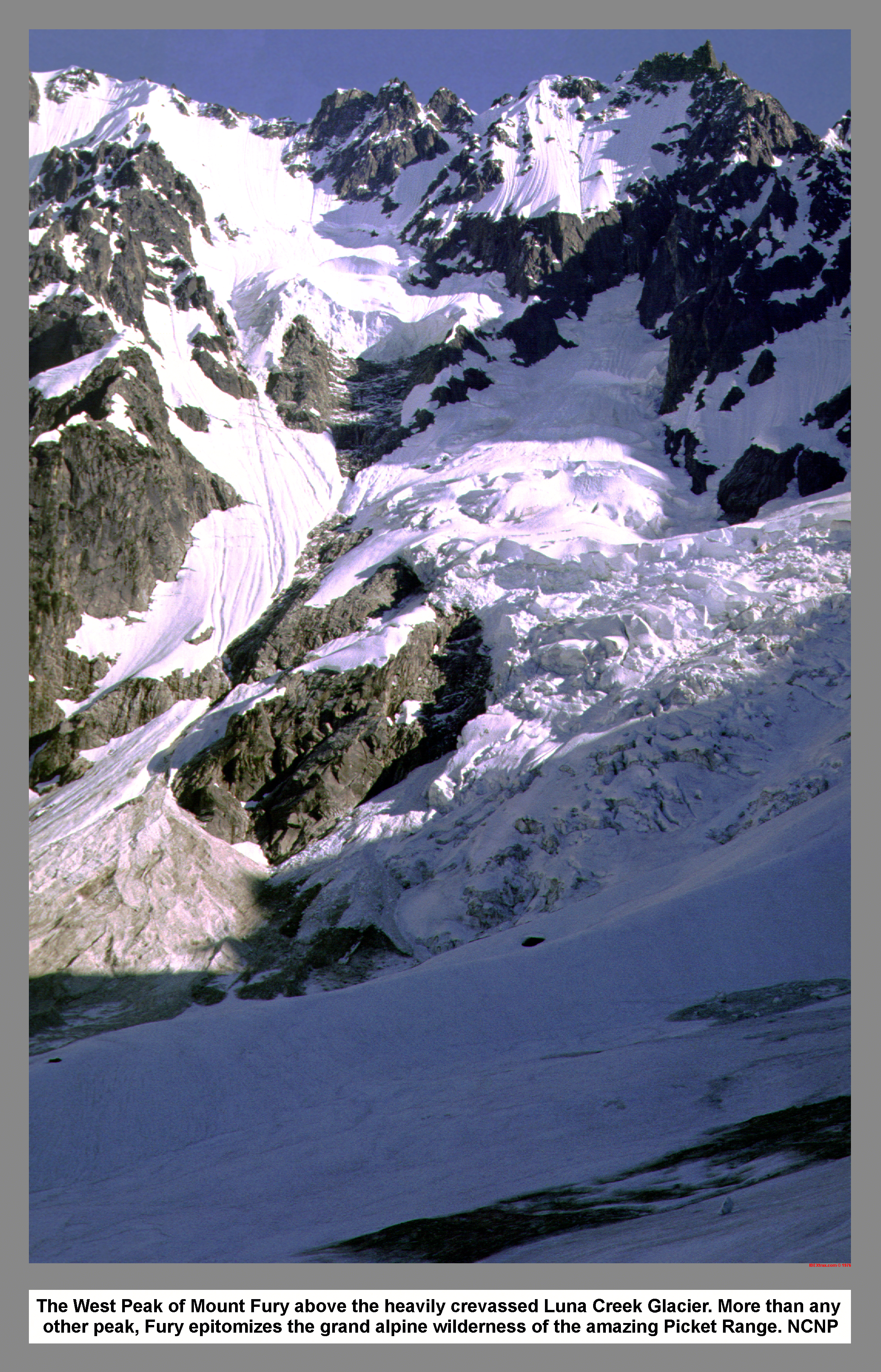
The West Peak of Mount Fury above the heavily crevassed Luna Creek Glacier. More than any other peak, Fury epitomizes the grand alpine wilderness of the amazing Picket Range. NCNP
As we sat on the barren moraine and munched Granola bars, the sun left the valley of Luna Creek. A chilling wind persuaded us to move along. Just north of the moraine we found some mysterious sunken snow holes. We climbed up a slide track and then ascended a major ramp that conveniently led through the cliffs. Half way up the ramp, we dropped around another spectacular waterfall. Near the top of the ramp, we cut up through the trees and then over rock. As the setting sun turned Luna Peak pink, we climbed up the open snow slopes of challenger arm. At the first possible tarp site, we deposited our packs and then climbed higher in search of a better spot.

The best spot was found at the 6,000 foot level. It had been a hard day and it showed when John and I were sucked into disagreement over sleeping spots. The echo of falling ice thundered around Luna Cirque as we ate a solemn dinner. For the first time in three nights I slept soundly in the absence of hanging ice or teetering rocks above my head.
 We were graced with another cloudless sunny morning on the fifteenth.
 After breakfast, we stuff the nine millimeter rope and the half rack of Hexcentric chocks into a pack and then went off to climb Mount Challenger. We kicked out a reusable track to the crest of Challenger Arm. We rested on the last rock outcrop before the glacier and drank and talked. John led up to the bergschrund and then walked over it unroped. We tied into the rope after stopping between some large crevasses. We skirted a large crack in the saddle, and then climbed steep snow. Just below the false summit we traversed on ice and rock.
04 069 Warren leads on the Challenger Glacier
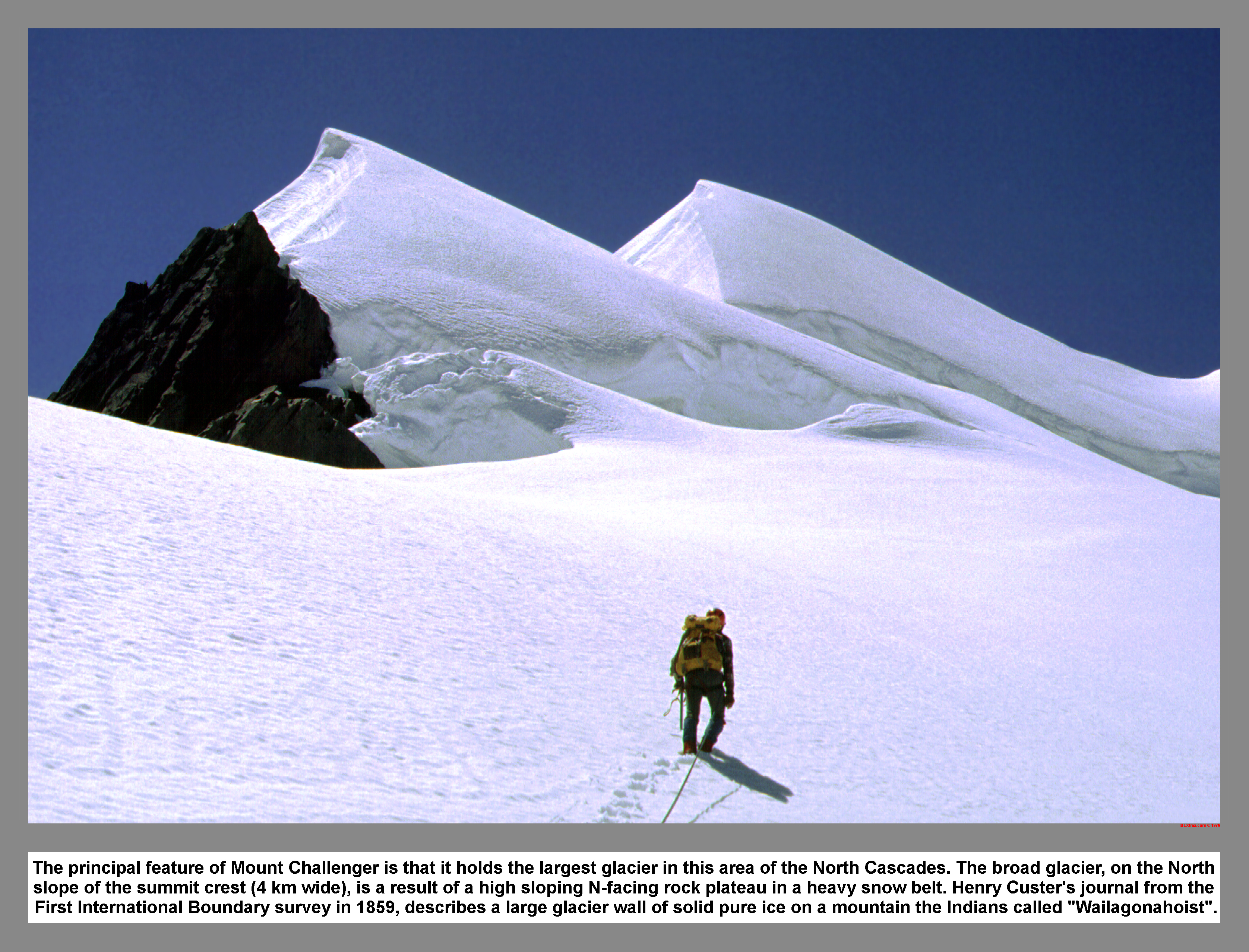
The principal feature of Mount Challenger is that it holds the largest glacier in this area of the North Cascades. The broad glacier, on the North slope of the summit crest (4 km wide), is a result of a high sloping N-facing rock plateau in a heavy snow belt. Henry Custer's journal from the First International Boundary survey in 1859, describes a large glacier wall of solid pure ice on a mountain the Indians called "Wailagonahoist".
04 073 Warren on the summit of Mt Challenger
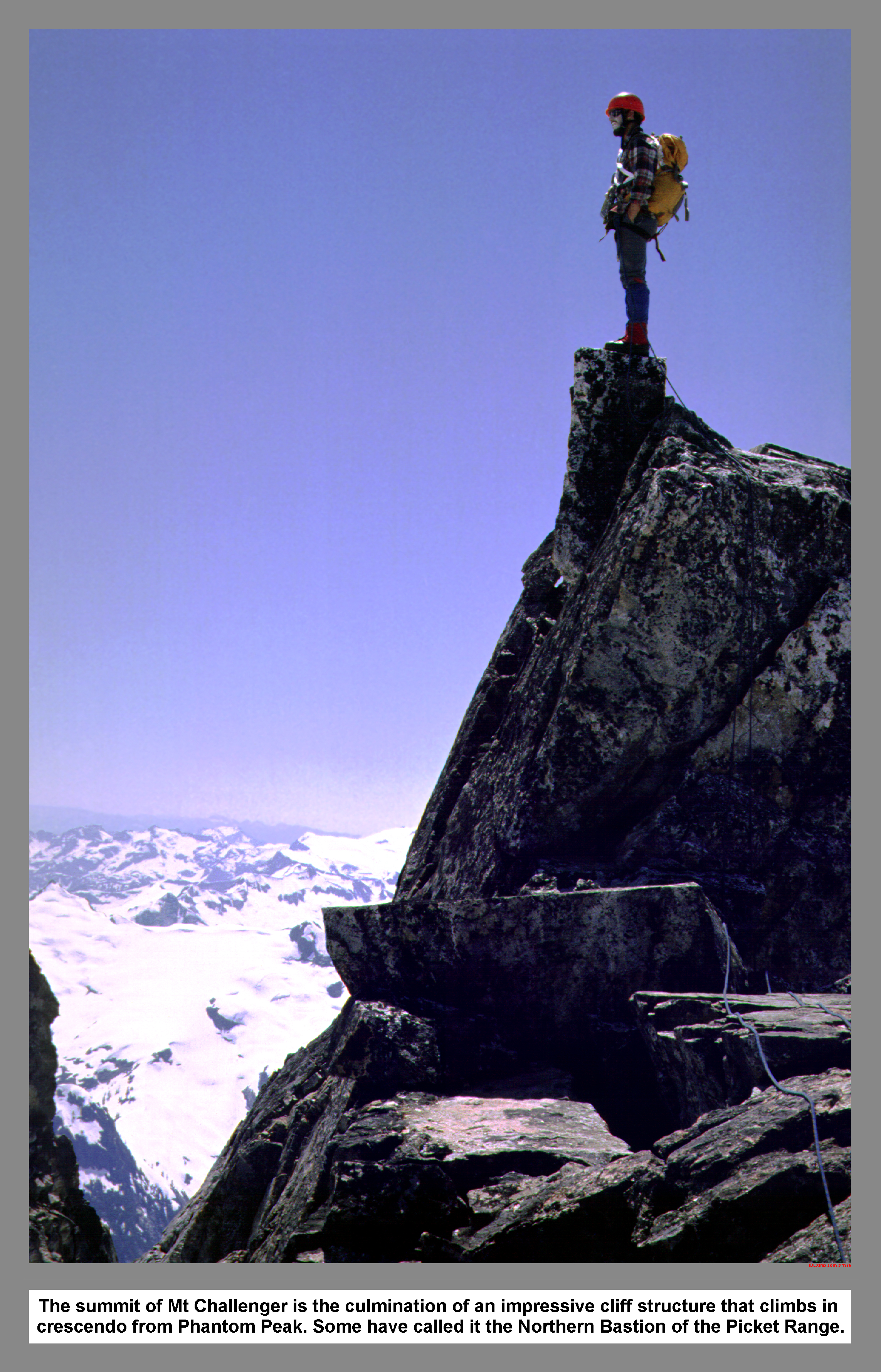
The summit of Mt Challenger is the culmination of an impressive cliff structure that climbs in crescendo from Phantom Peak. Some have called it the Northern Bastion of the Picket Range.
04 074 Crooked Thumb with Mt Baker Mt Shuksan Mt Ruth
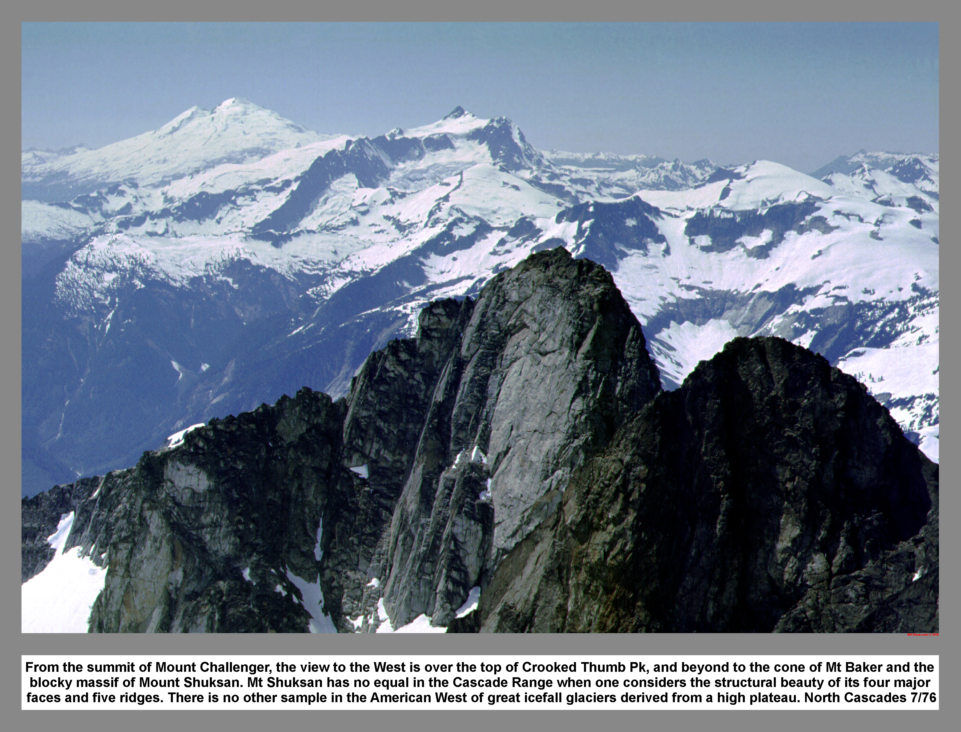
From the summit of Mount Challenger, the view to the West is over the top of Crooked Thumb Pk, and beyond to the cone of Mt Baker and the blocky massif of Mount Shuksan. Mt Shuksan has no equal in the Cascade Range when one considers the structural beauty of its four major faces and five ridges. There is no other sample in the American West of great icefall glaciers derived from a high plateau. North Cascades 7/76
04 075 John B raps off Mt Challenger Mt Baker Mt Shuksan
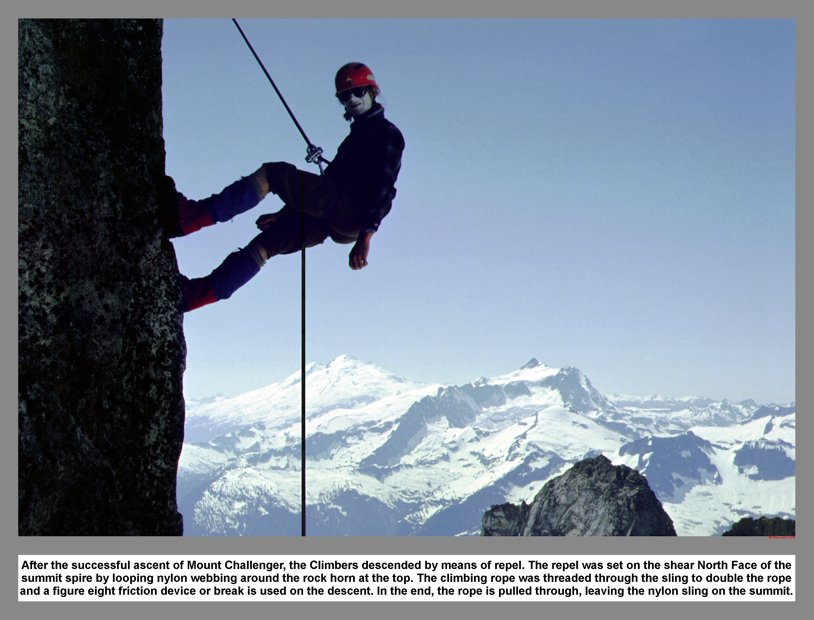
After the successful ascent of Mount Challenger, the Climbers descended by means of repel. The repel was set on the shear North Face of the summit spire by looping nylon webbing around the rock horn at the top. The climbing rope was threaded through the sling to double the rope and a figure eight friction device or break is used on the descent. In the end, the rope is pulled through, leaving the nylon sling on the summit.
04 076 John B on Challenger Gl Wiley Lk High Route beyond

On the descent of the Challenger Glacier and the return to Challenger Arm, the Climbers paused to check out the Wiley Lake High Route. The plan was to use the Wiley Lk High Route as an exit route from the Picket Range. This most common approach for Mount Challenger and the Northern Pickets, extending from near Beaver Pass and affords the easiest going on bench and meadow South (right) of the crest. NCNP 7/76
04 077 Crooked Thumb Mt Challenger above Challenger Arm
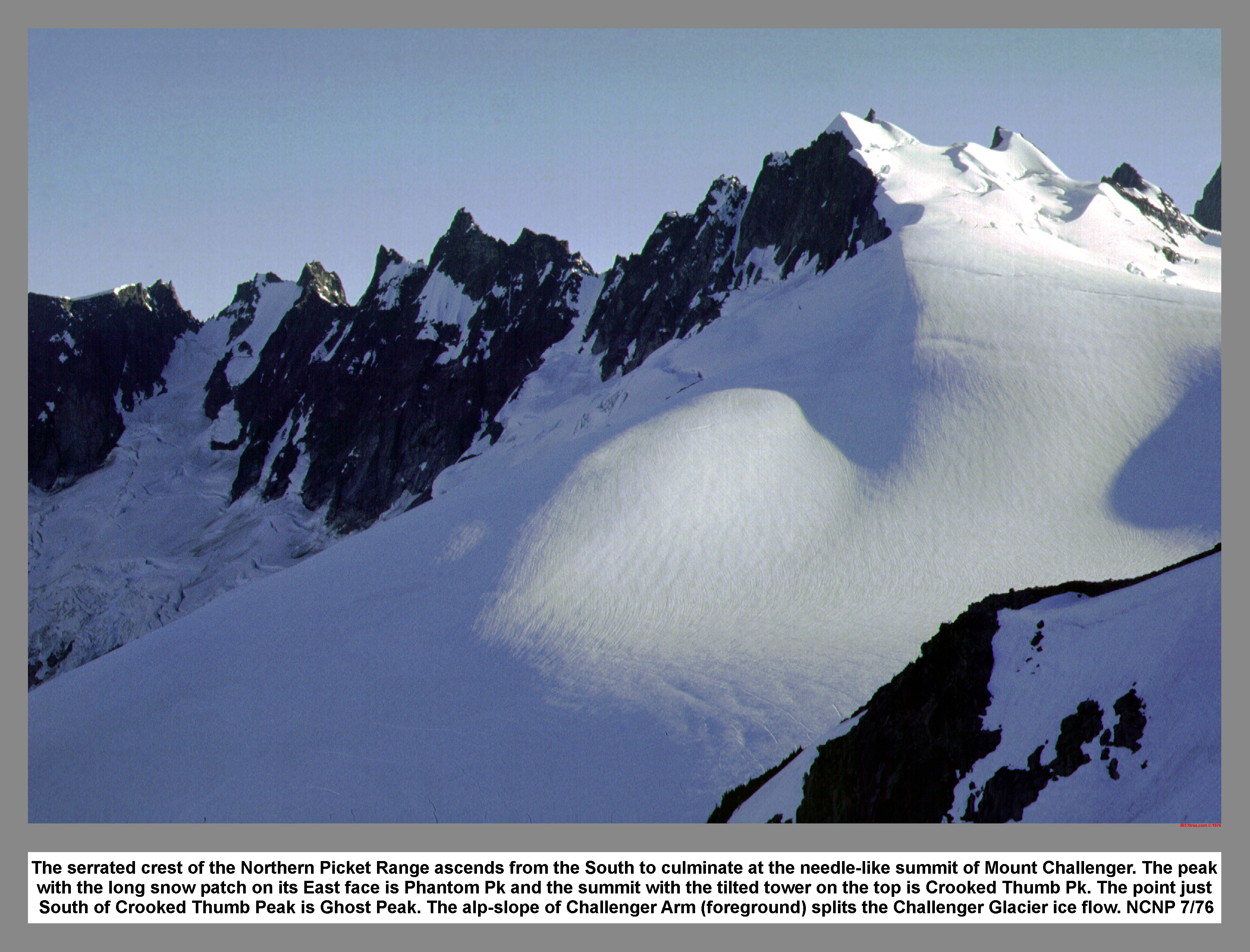
The serrated crest of the Northern Picket Range ascends from the South to culminate at the needle-like summit of Mount Challenger. The peak with the long snow patch on its East face is Phantom Pk and the summit with the tilted tower on the top is Crooked Thumb Pk. The point just South of Crooked Thumb Peak is Ghost Peak. The alp-slope of Challenger Arm (foreground) splits the Challenger Glacier ice flow. NCNP 7/76
John set up a belay at the base of the summit block, and then I climbed up past some fixed pins. Just to say that I carried all those chocks all that way for a reason, I place the largest number ten jam nut before I left the difficult climbing. John came up and then we scramble to the top. We read the registered and absorb the view. The south face looked like a good climb. We eased back down an exposed slab and then rigged a rappel. The rope pulled through without a hitch. After tying back into the rope, we follow the Challenger Glacier crest back down to the saddle. We followed our tracks down the soft snow until we re-crossed the bergschrund. We then unroped and struck out for camp on a B-line. When we reached the tarp we packed up our gear.
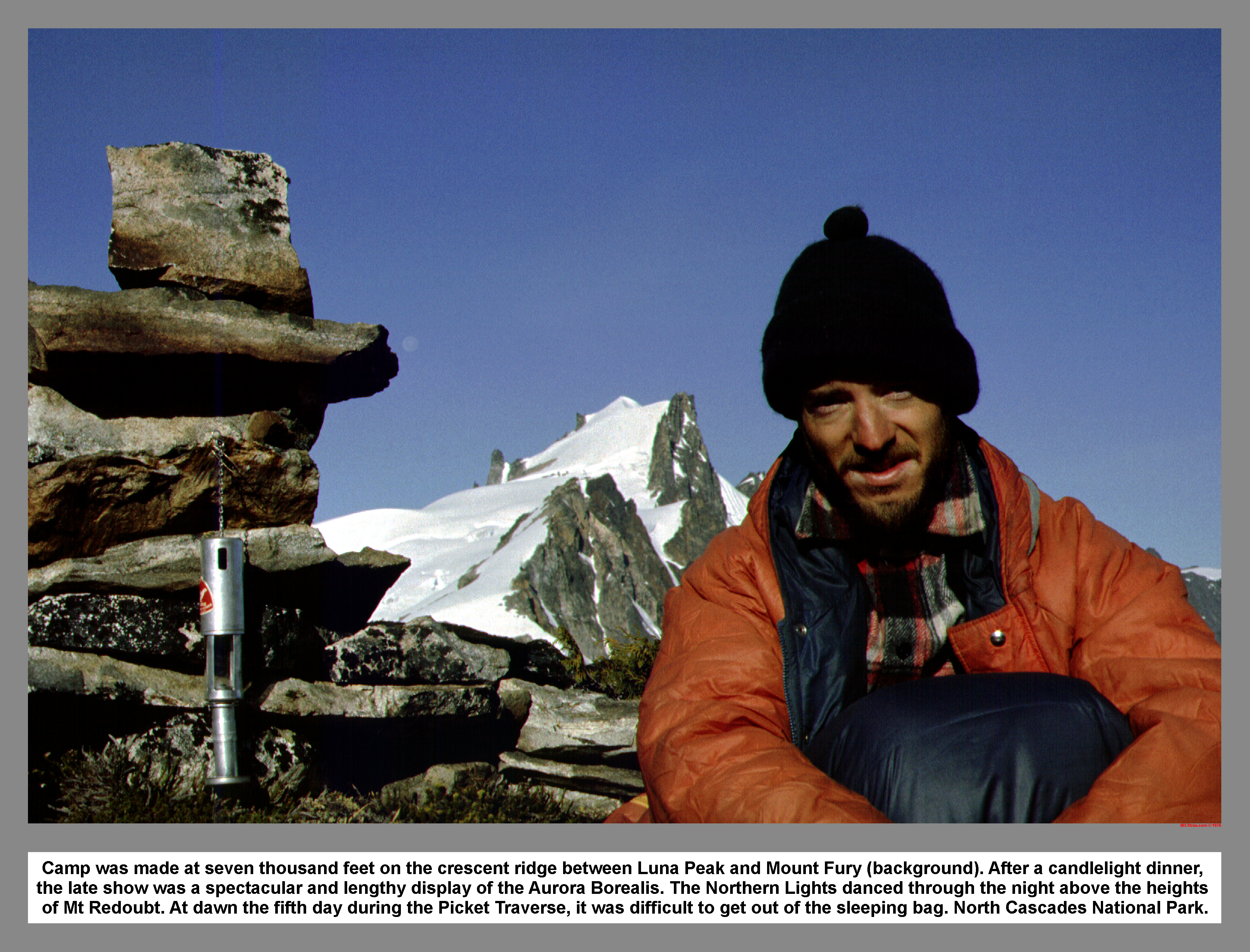
We retraced the pre-made track to the crest of Challenger Arm, and then contoured around the Challenger Glacier. After passing into the shadow of Peak 7304, I rested on a rock and waited for John to coil the rope. I offered John my resting rock and then led up the steep snow gully. The gully topped out at 7,000 feet on a broad plateau located a quarter mile east of Peak 7374. We passed a good campsite, but then turn around later to go back. We decided not to set the tarp due to the cloudless sky. We sat on a lichen encrusted boulder, smeared on bug repellent and talked while we absorbed the last rays of the setting sun. When John returned from getting water, he told of a hair raising downhill chase of a runaway pan. We cannibalized one of the dinners and produced a big filling meal. John thought we were not getting along that well. I told him that my quiet nature didn't mean that I was unhappy. We talked it out and found a better understanding. As I lay in my sleeping bag watching the stars, I was distracted by a faint band of light that moved across the northern sky. It was the first time I'd seen such a displayed, but I knew that it must be the Aurora Borealis. John and I watched for a long long time as the luminous streamers of green and blue moved across the northern sky with varying intensity.
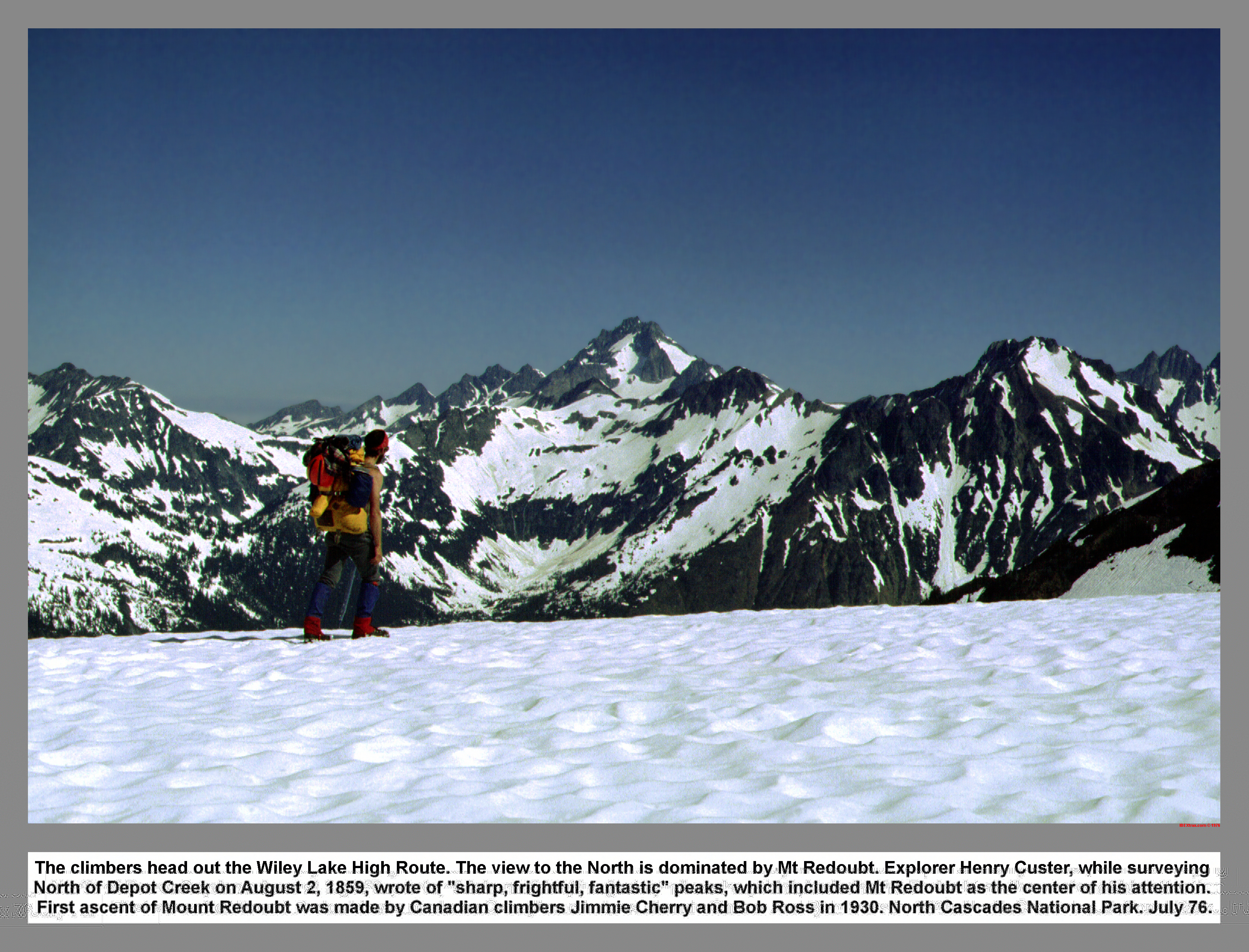
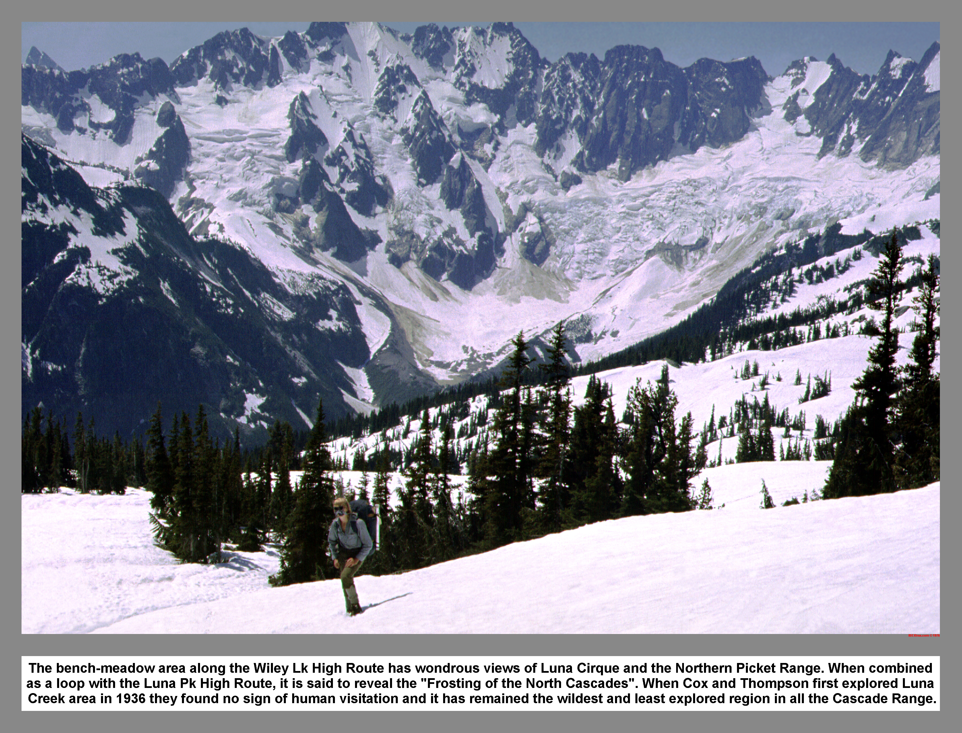
I looked out through the mosquito netting at another cloudless morning, and just before I was roasted out of my sleeping bag, I got up. After breakfast and packing, we headed out the Wiley Lake high route. Our route dropped below ice covered Wiley and Eiley Lakes. After climbing over the top of Peak 6955 or 6984, we hiked along the ridge crest and enjoyed the pleasures of ridge running. The views to the north of Mount Redoubt were fantastic. The Wiley Lake high route is said to reveal the Frosting of the North Cascades. And what a delicious and creamy taste it is.
 We dropped off the ridge too early and paid for it when we encountered some tricky gullies. We regained the ridge crest at the end of the ridge and then enjoyed a glissade down good snow. As we descended toward Beaver Pass we picked our way down on receding snow patches that gave way to small evergreens. We moved left and crossed a creek. Then the battle started as I bulled my way through some vine maple. We thundered down through the brush and didn't let up until we reached the open forest of Beaver Pass. As we wove through some Devil's Club, I notice that the bugs were thickening. I began to think that we had somehow passed over the Big Beaver trail when we found the trail.
We followed the fresh tracks on the trail until we stopped at the first water. We made it a major rest stop and washed off the fur needles and twigs that we had collected on the brush fighting descent. While the mint tea brewed, I slipped into fresh sox to prepare for the foot eating trail ahead. It was nine miles to Thirty Nine Mile Camp. So, John led down from the pass with the goal of three miles per hour. We flew past the Beaver Pass Shelter at a good clip, and then from that brief glimpse I got of it, it looked in good shape. In the first few miles of the trail, we descended to the valley floor via a long series of switchbacks. Where the trail passed through an open meadow, we saw the first person we had seen in seven days. He was a solo hiker from back east. I stopped and looked up Luna Creek at the cirque we had crossed three days before.
 I felt proud that I had seen more than this meager view. We passed another solo hiker who asked if we were going to Luna Camp. We answered no and moved on. We soon passed Luna Camp and then a separate horse camp. All the foot pounding was getting to be a drag. I made a slight mistake and told John about my "Tail-gate-phobia" and then he over reacted. John dropped way back. So, with a feeling of mischief, I sprung around after a long straight and yelled back at John, "I see you." We both laughed. The seemingly endless trail wore on and on. But, we finally reached Ten Mile Shelter.
We met a young ranger that was watering some of the plants in a reforestation area near the shelter. He seemed surprised when we told him where we had been. Initially he was concerned. But, he was relieved to see our short Sumner Ice axes when we turned. Throughout the whole conversation with the ranger, he used a crushing brushing rhythm against the swarming mosquitoes. I was amazed he was wearing shorts. The Ten Mile Shelter was still standing when we left, but I felt that it would go the way of other old shelters like it and be destroyed by defensive over use tactics use by the Park Service. Another half mile down the trail, we turn down at the sign that marked Thirty Nine Mile Camp. The camp was one of the new park service camps with isolated camps set in thick second growth timber. We picked one of the camping units, and then I went to find a place to soak my sore feet. My feet felt much better after I numbed them in the cold creek water. John found me and we walked back to camp with full water bottles. We could do nothing but laze around the camp and try to find enough energy to eat after the thirteen mile day. I finally cooked dinner. I used my mosquito net to find sleep, but I didn't need it.
We got up early and hit the trail before the sun filtered through the trees. It was Twelve miles to Ross Dam. So, we started out at a good fast pace. The trail skirted a meadow area that was flooded by a beaver dam. We found fresh deer tracks on the trail. John increase his speed and I tried to keep up for only a short distance. I settled into an easier pace and watched the miles go by. Before I expected it, we arrived at the new bridge over the mouth of Big Beaver Creek on Ross Lake. John tried his fishing skills in the too fast water, while I picked and ate salmon berries along the bank. I started up the trail while John stowed his fishing gear. I met an elderly couple that I talked with. I find that I always walk away with a good feeling when I talk to people who have found wisdom through experience. We climbed the switchbacks and then crossed Pierce creek at a deep gorge. The trail leveled off and traversed semi open slopes above Ross Lake. The lake had not turned milky blue yet due to the heavy snow pack that still lay in the Picket Range. Soon after we pass the cut off to Sourdough Lookout, we searched out a shady rest spot to escape from the hot sun.
Just before we reached the Green Point camp, we came upon a small black bear. The bear ran across the trail and then disappeared into the brush above. We picked the right trail at the resort and then continued down to Ross Dam. The dam was as big as I'd heard it was. After crossing over the top of the dam, I was almost blown over by the strong gust that roared over the south side of the dam. I followed John up an abandon construction road. We were literally turned around by two beautiful girls. The young heroines led us back to the trail we had passed, and then they disappeared up the trail with a lingering display of long tanned legs and tight white short shorts. We took a rest stop in a cool alcove that held a small creek. I met a friend, I had met at Boeing, as I walked up to the crowded parking lot. John changed into some clothes that he had stashed in the car, while I sat on the fin of his 59 Chevy and took in all the activity of the parking lot.
We drove over the North Cascades highway, picked up two Wenatchee bound hitchhikers, and then stopped in Twisp for hot Fudge Sundaes. We drove on through the Methow and then past Chelan. We dropped the hitchhikers in east Wenatchee. The Columbia Hotel Buffet was closed. So, we settled for pizza before cruising to Leavenworth. We turned up the Icicle Creek Road and then ended up sleeping under the stars at the familiar Bruce's Boulder Camp. After breakfast in Leavenworth, we spent half the day watching a kayak competition on the Wenatchee River. When we left it looked like the river was winning. We met Lee Moyer who had led me down my first kayak river trip. We headed back over Stevens Pass feeling satisfied and inspired by all we had seen and the experience we had gained in the past week.
|
|
|
|
|
|
This site created and maintained by THE IBEX - Page last revised:
|
|