
|
|
IBEXtrax.com - Cascade Mountains of Washington StateNorth Cascades Park |
|
|
I had been working at the Boeing plant in Everett, Washington for ten months. I was working the day shift doing electrical modification on seven-forty-seven airplanes. The modification program was very shifty; it was either a feast with all the overtime you wanted, or famine with no work to do at all. During the famine of late July 1975, I found myself with eight days of excused leave of absents.
I planned a trip to the North Cascades: The first day I planned to climb Mount Ross, and then make camp just north of the summit. The second day would be ridge running that included a questionable traverse above Azure Lake. The second night would be spent in McMillan Cirque. The next day was to be a climb to Picket Pass, and followed by an ascent of Mount Fury's southeast arm. The route was questionable through Luna Pass to Luna Lake. The fourth day was planned to be a round trip day hike to Challenger Arm. For the fifth and sixth days, I planned to sprint out Luna Peak High Route and then jump on the Big Beaver Creek Trail to Ross Dam.
The plan was set, but I needed a ride north to North Cascades National Park. I managed to barrow my dad's Ford Pinto and left early on the morning of the twenty forth. I had an enjoyable time driving that little yellow go-cart. The weather was fantastic.
I picked up a hitchhiker in Concrete. He had been roaming through Canada, and how he wanted to see the North Cascades. We stopped in Marblemount to check in with the ranger. A good-looking ranger made out my permit while her boss watched over her shoulder. At first the senior ranger was concerned about my safety and recited the obligatory warnings. But, after a few questions that I confidently answered, he said, "It should be fun." My rider was to do a loop trip: up over Fourth of July Pass, down Fisher Creek to Thunder Creek, and then out Thunder Arm. We drove back down to the Marblemount store for a lunch stop.
I dropped the hitch hiker in the middle of Newhalem, and then drove around looking for a line of assault on Mount Ross. I parked the Pinto in a junky surplus yard on the north edge of Newhalem. As I stepped from junk yard to Ross Lake National Recreation Area, I noticed how light and comfortable my pack was. The climb started out by following a dry creek bed. After a short distance, I cut up through some light brush, and then passed through an open cliffy zone. To fend off the heat of the day I stripped down to shorts and then climbed up in the open timber. I followed a rib up to the right until I was forced left. There was a short scramble on steep mossy rock. I drank the last of my water just before I reached the echo board. The echo board was part of the micro-wave link from Seattle to Newhalem. When the sun started getting low, the mosquitoes started to attack. I used my wind parka for protection from the bugs, and I used repellent on my hands. A soaring hawk drifted by and screeched, and I wondered if he was protesting or calling a warning.
At thirty-three hundred feet above Newhalem, I came upon a stagnant water hole. I drank a cup and stored a quart. A little higher up, the terrain leveled off. I walked along an open glacial polished plateau that was cut with a band of stunted evergreens. The night was closing in, but I had to climb higher to reach the melt water. I was getting tired. I followed game trails and wondered if I would meet a bear. When I reached the headwall, I traversed left on talus. There was some exposed climbing to get into a steep water chute. After I bloated myself with the cold aerated melt water, I decided not to climb higher that day. With the light failing, I built a sleeping platform of windfall branches to keep from falling down the steep slope. Using my tent as a bivouac sack, I crawled inside to escape the ferocious mosquitoes. I enjoyed the convenience and taste of a freeze-dried meal. I had a surprisingly comfortable sleep.
On the morning of the twenty fifth, I awoke to find the gully filled with fog. I slept in. When I finally got up, the sun was out, and the bugs were biting. I ate Super Sugar Crisp, as I would throughout the trip, for breakfast. After I packed, I scrambled up beside the waterfall. I moved right and followed a parallel gully that was spotted with Avalanche Lilies. At one thousand feet above my camp, I made an exit from the gully by moving left. A short stretch of brush was done hand-over-hand. As I climbed higher the snow patches became larger and the rock patches became smaller.
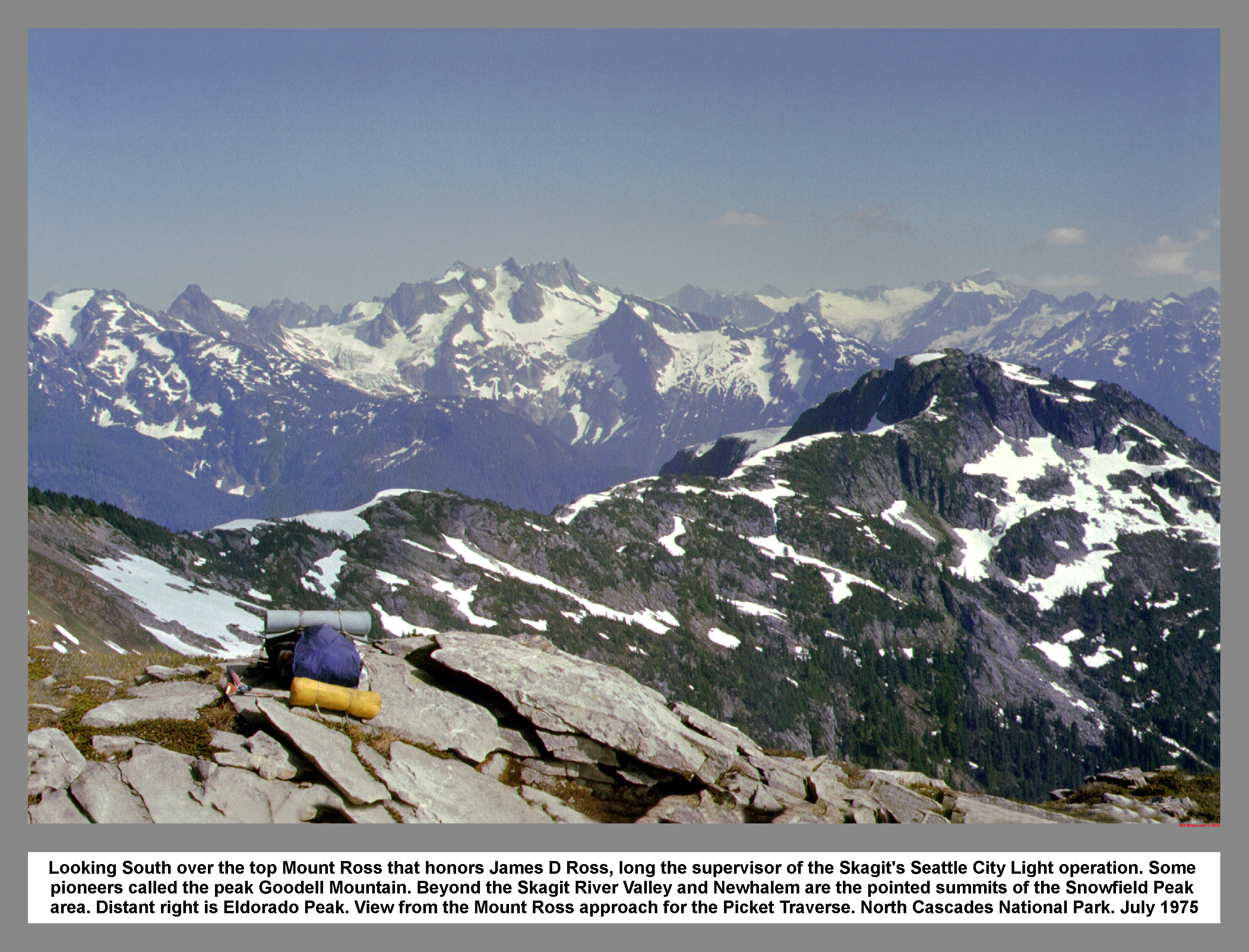 I traversed around the summit on a freeway size ledge. On the snow-covered freeway I noticed that the bugs were falling behind. I dropped my pack, grabbed my axe, and scrambled to the summit of Mount Ross. The day was clear, and the view was good. In the register I found a single-entry date of June of 1969. After signing in I dropped back down to my pack and then followed the snow covered bench north. It was noon. In the Route and Rocks guide, the area north of Mount Ross was marked with question marks. This indicated an untried route. But, I easily gained the ridge.
 The pleasures of ridge running are numerous. The ridge top traveler is above the brush and trees. Around every corner is a more spectacular view. The only possible drawback is that it's hard to put your head down and make good time. The ever-changing vista as you travel, reveals the depth of ridge upon ridge and peak after peak. The snow conditions were good. I walked between heather dotted rockeries that were each a masterpiece of landscaping. I strolled along taking in the view. I munched now and then on jerky, mint cake, and lemon drops. I was glad that I wasn't down in Goodell Creek.
 The first good view of the southern Pickets was from the west ridge of P6705(The Roost). On the ridge was a big flat rock. I reclined on the rock and snacked, while studying the Terror Glacier. The route swept around the northwest cirque of P6705(The Roost) to meet the ridge. I climbed some interesting slabs as I regained the ridge. It was a stroll over the rounded summit of P6l82.
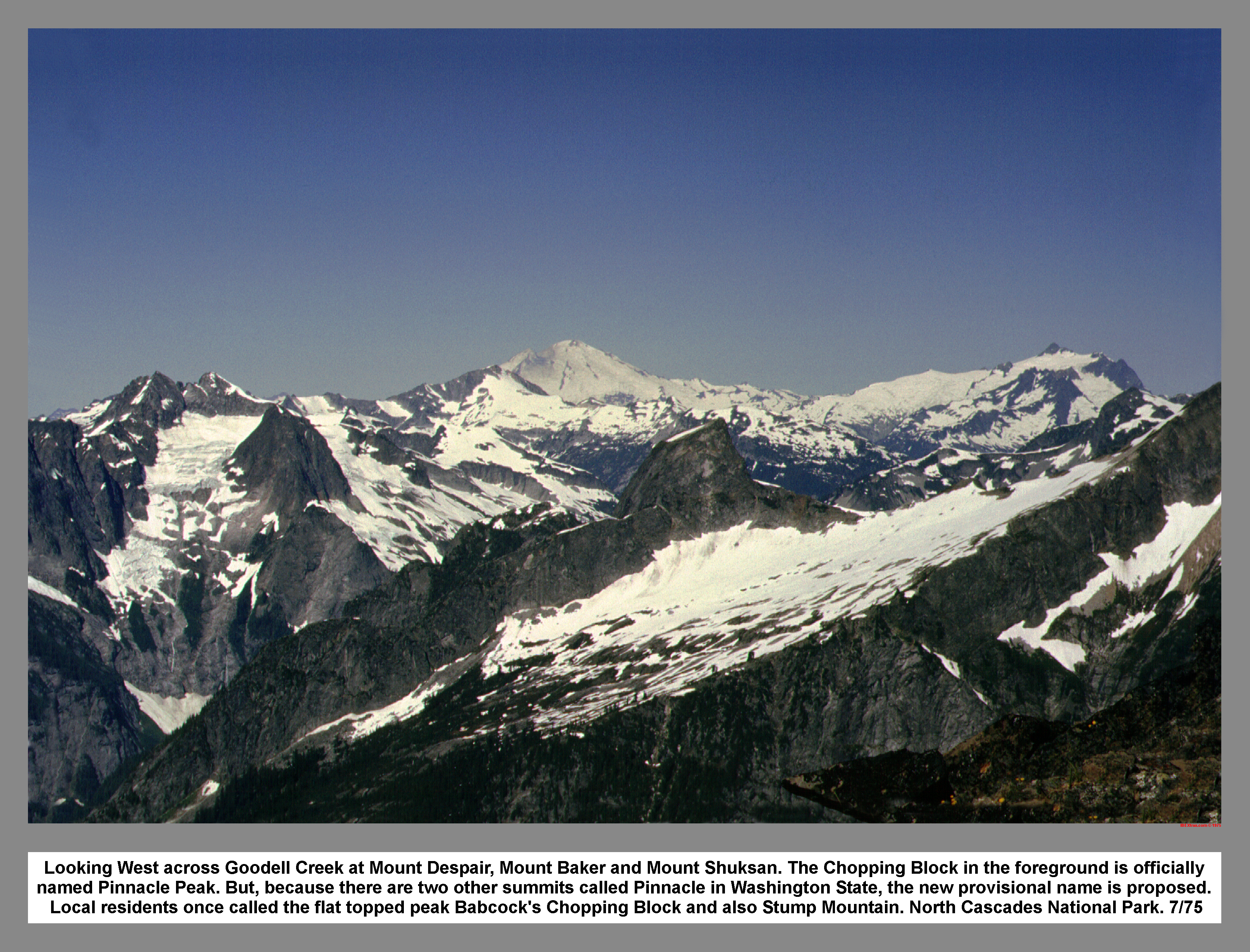
The sun was getting low as I skated down to the pass south of P7200+. The view was good of the peaks across Goodell Creek. The hanging Jay Creek Glacier on the back side of P6705(The Roost) looked impossible.
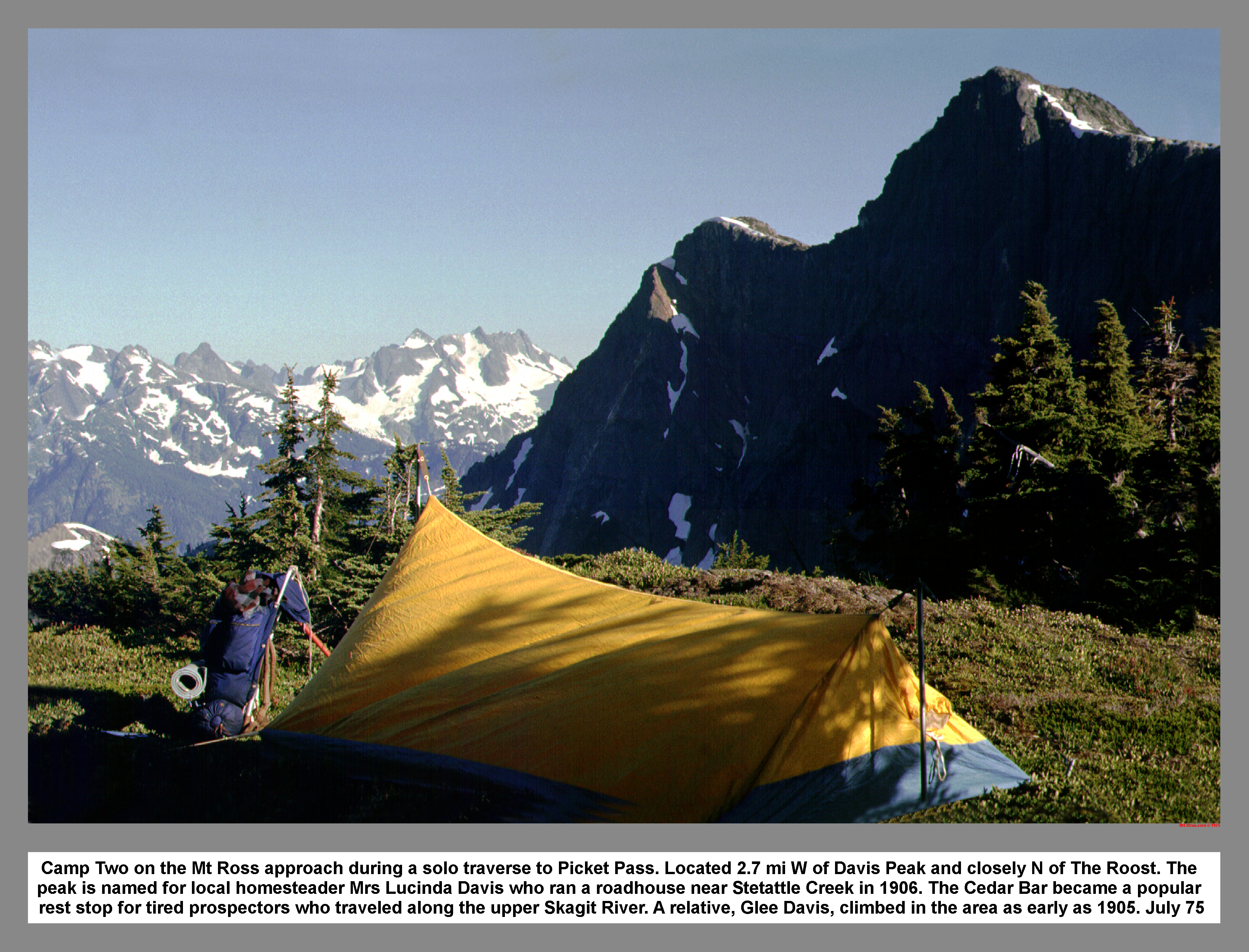 I made camp on a small alp above the pass. With a fine view to the southwest combined with water only a few steps away on a snow patch, the camp was perfect. The bugs tried to bother me, but I moved to a breezy rock and absorbed the view and the last rays of the sun. After sunset a few gusts of wind persuaded me into the tent. I cooked another freeze-dried meal in the tent. The gusts of wind tried to flap the tent, but I didn't put the rain fly on. While I ate dinner, I watched the darkness fade the Mountain scape. I was awaken during the night by the thundering boom of falling ice.
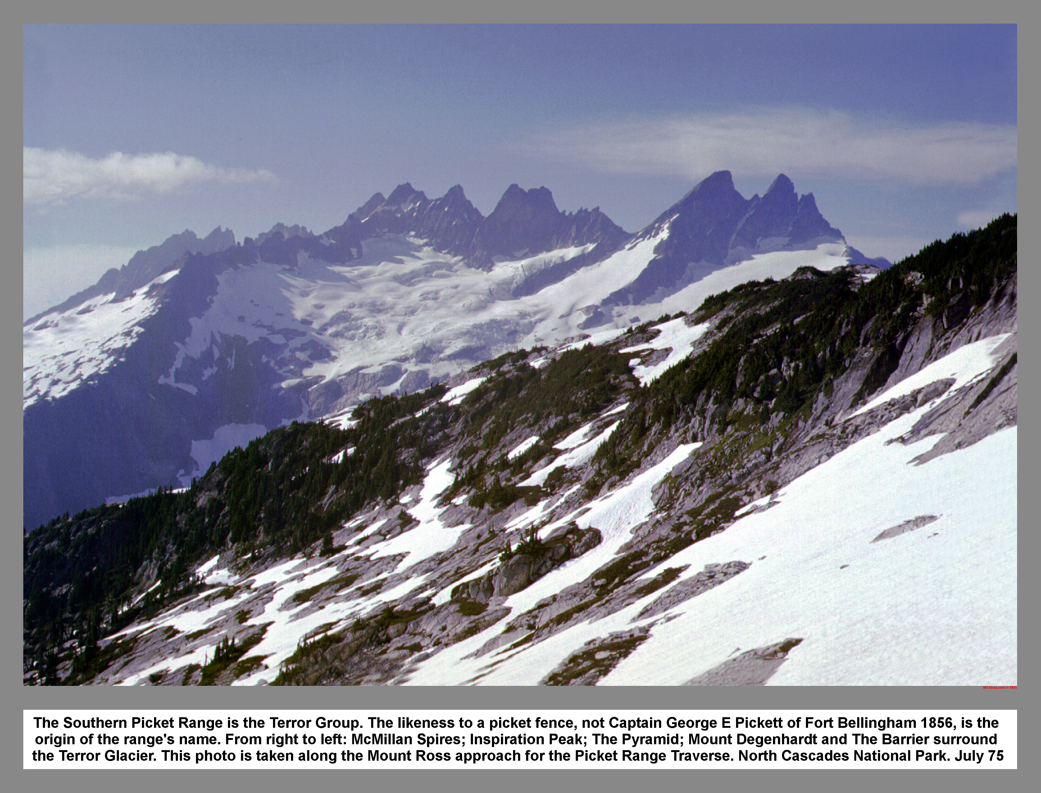
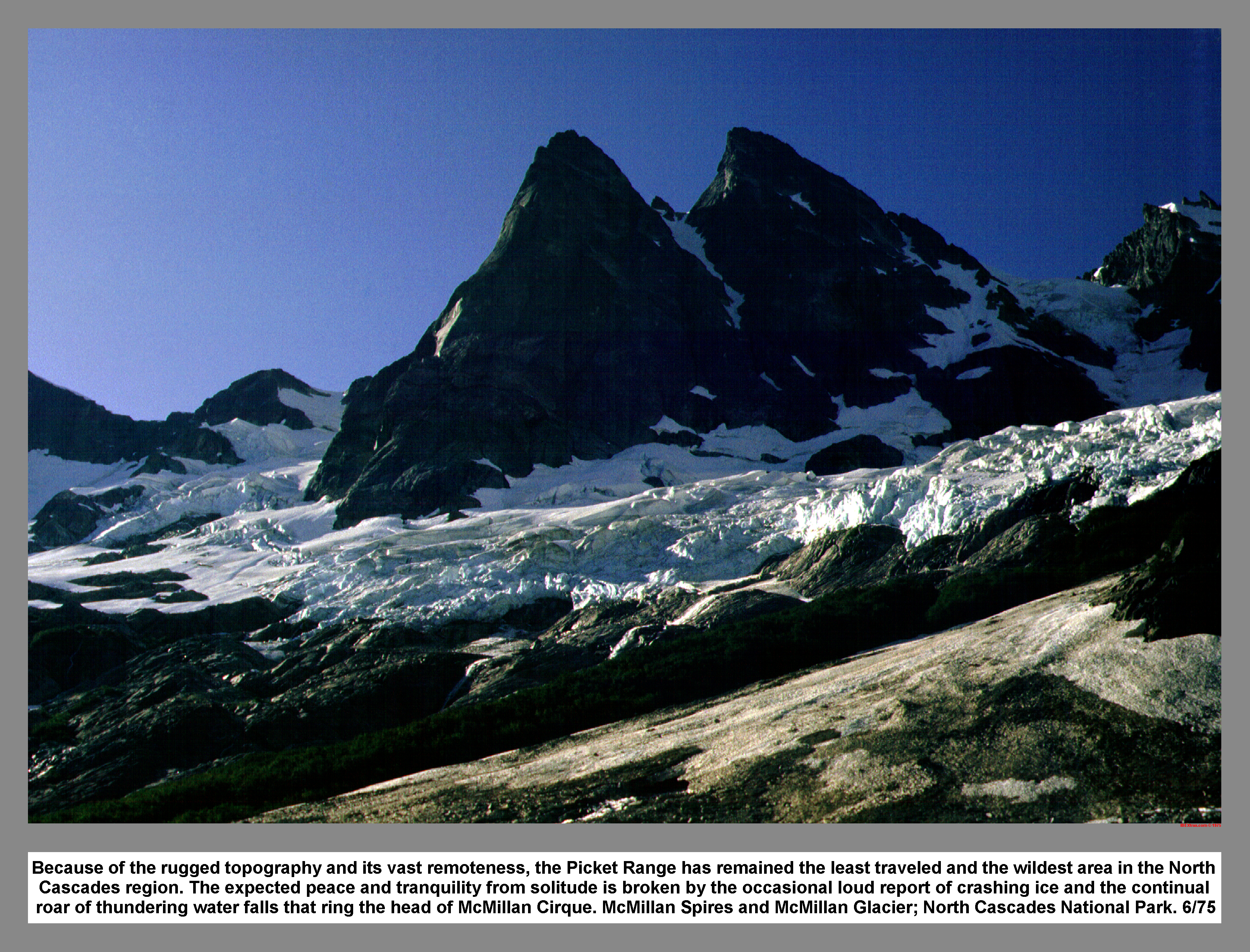
 On Saturday I slept in again. After breakfast and packing, I then climbed to the top of "Glee's Knee" (P7200+) by using the south buttress near the top. It was an impressive sight from the summit. The southern Pickets rose abruptly from the fractured Terror Glacier and sliced the blue sky with their dark summits.
I climbed down to the north col by dropping to the east side of the summit. From the col I traversed to clear the run out before I glissaded down. With polished rocks poking out of the old glacier, the slope looked like a white garden of rocks. I saw two rope teams on the Terror Glacier, but I lost sight of them when they entered a gully high on The Barrier.
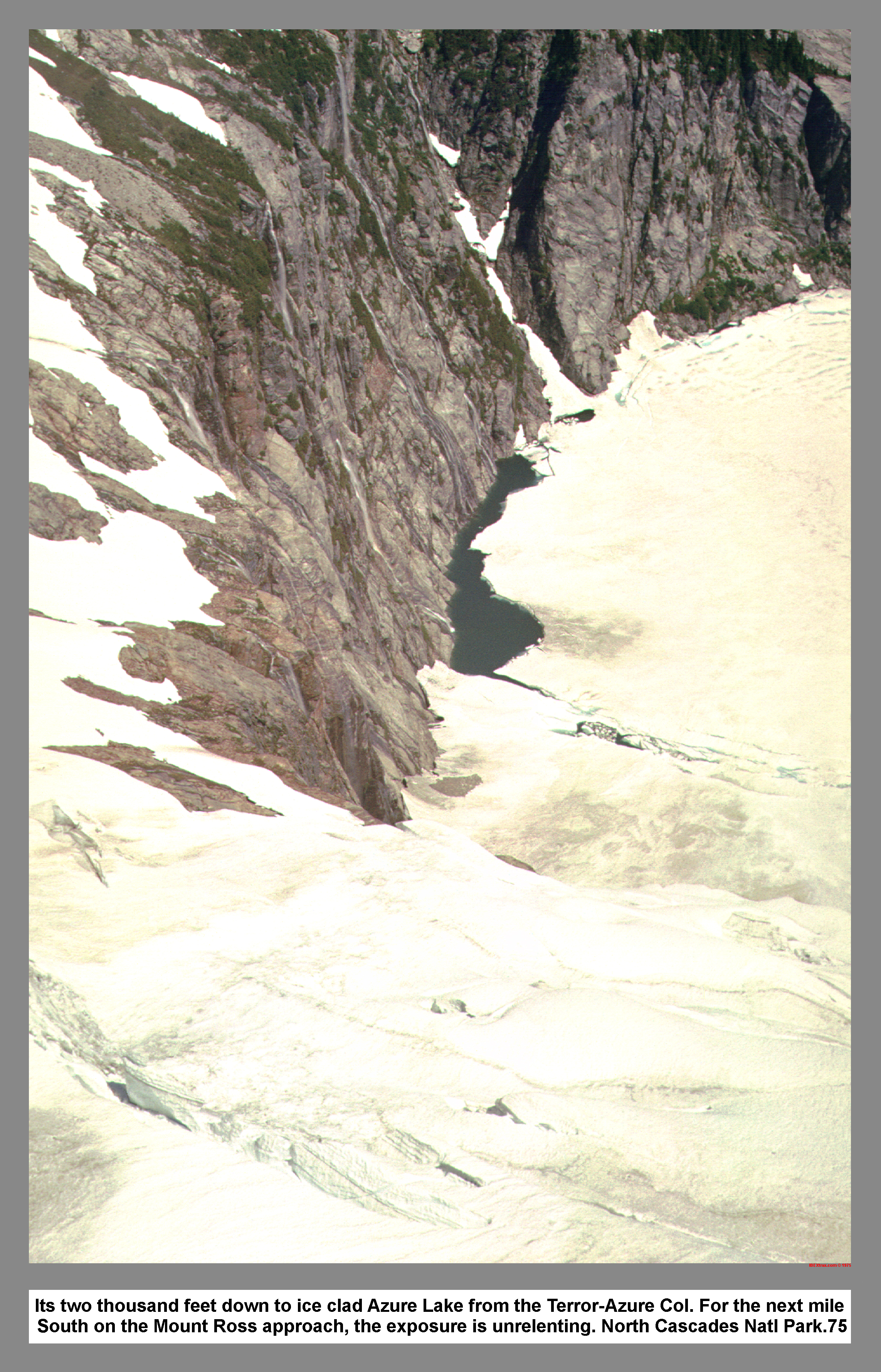
I picked up the tracks of a party that had come up from Goodell Creek. The tracks soon dropped down, but I held my altitude and contoured to the lowest pass west of Azure Lake. It was a breathtaking view down to Azure Lake.
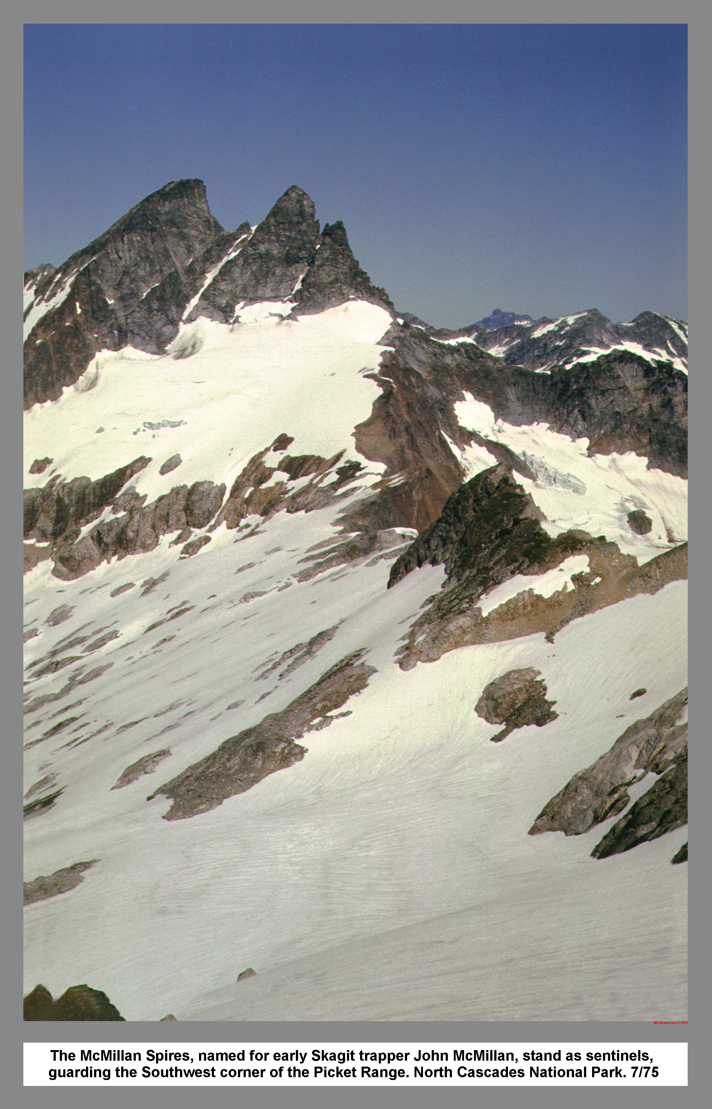 The climb up the snowy slope at the foot of McMillan Spires ended at the headwall. I traversed right on steep snow to a notch in the rocks. I looked around the corner and found that I was standing at the gate of the key ledge. The ledge was wide and surfaced with sharp gravel. At the north end of the ledge, there was a bivouac site. I climbed up a moat and followed a snow arete down the northeast ridge of McMillan Spires. The exposure was tremendous, so I backed down onto the terraced south slope. It was an excitingly dangerous route. In a few spots I backed down and reminded myself that I was alone. I saw a party of six that was crossing Azure Pass. I climbed on some exposed ledges and went down some steep snow. I left my pack above the pass and went over to talk. As I passed through the pass there was a distinct smell of sulfur. I thought about Mount Baker.
 I walked up to them unnoticed until one of them said, "Where did you come from." I pointed toward McMillan Spires and then fingered them for their story: From Connecticut; "This is amazing country."; Fighting brush on Stetattle Creek for three days; One young man got separated for one night. They said they were going to Picket Pass too. However, I never saw them again.
I left them belaying down a steep corniced step. After retrieving my pack, I casually waved goodbye as I confidently plunged down the steep snow slope then skated down into McMillan Cirque. I bypassed two small crevasses by climbing down a rock island. While traversing down over large sun cups, my boots began to clog, so I began the rhythmic tap with my axe. I tried to understand the Tabor and Crowder guide, but it was confusing because the guide explained the route in the opposite direction. As I dropped around a steep rock buttress, I surprised a scraggly looking Mountain goat. I followed the goats tracks through some uneven crevasses and then hurried through some fresh avalanche debris.
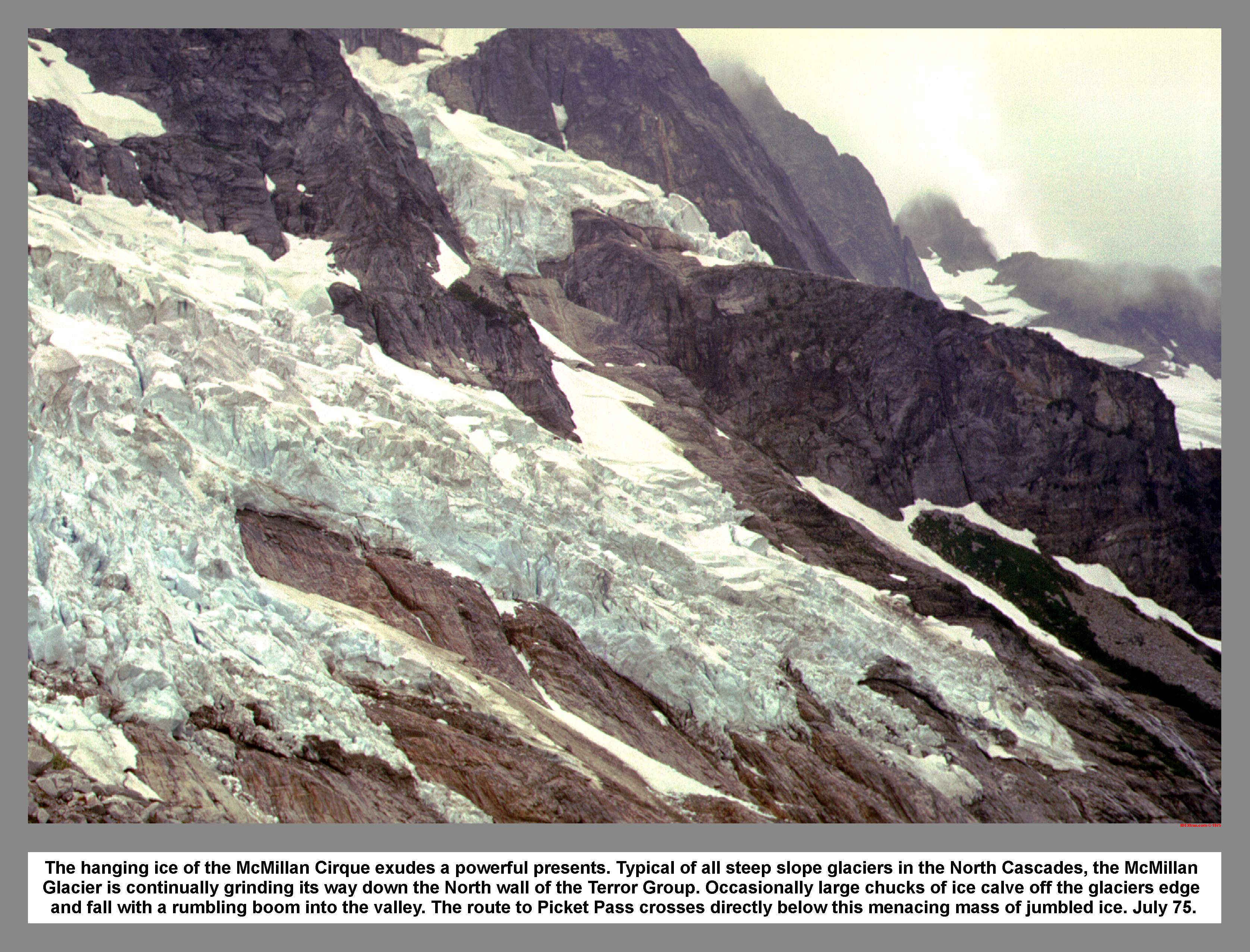 On a talus rib I sat amazed, looking at the jumbled ice of the McMillan Creek Glaciers. The sun winked behind Picket Pass, and I scrambled down, looking for the key ledge. I dropped down, off a good ledge, because the guide said that I would be tempted. The further down I went, the harder it became. I heard a rumbling crash and saw there was a small icefall above me off to the right. The slope became steeper, and I switched from facing out to facing in. I started to become concerned due to my doubt of the route below. I kept thinking that if I didn't make it, I would have to climb back up in the dark. The slope became a cliff, and I had to hug the rock to counterbalance my pack. Finally, I couldn't go any farther. The cliff was overhung below me. I noticed a small ledge that disappeared around a corner. With a very delicate reverse mantle I barely reached the ledge. As I traverse around the blind corner, I anticipated the moment of truth with an immense sense of adventure. I was relieved to see the ledge continue around and down to an ice packed avalanche fan.
The slope of the avalanche fan was littered with fresh signs of the previous icefall. I quickly made for the far side. I kept one eye on the ice above and the other eye and the ice under foot. As I neared the far side of the avalanche fan, a booming thunder reached my ears. I almost overdosed on my own adrenalin. Like a flash I was across and in the relative safety of the ice mangled slide alder. Again my eyes were fixed on the ice above, but I saw no ice fall.
If I followed a direct line to the cirque floor, I would have to fight three hundred yards of thick tangled vine maple and slide alder. I decided that any alternative would be better. So, I started to climb up toward the tip of the avalanche cone. I was still very excited due to the ice above.
While climbing up the boulders at the fringe of the brush barrier, and through sheer coincidence, I looked up to see a huge chunk of ice break off the glacier directly above me. I experienced shell shock and froze, unable to move or even blink. The sound of the huge chunk of ice breaking off the glacier was delayed and synchronized, so when the sound hit me, the large chunk exploded into large cubes. I frantically scrambled up to a better vantage point. Two dump truck size cubes bounded toward me in seemingly slow motion. Suddenly I saw that the ice was veering off to the left, down the avalanche fan. I was extremely relieved, and with an emotional release, I laughed hysterically. When I regained my composure, I completed the climb around the top of the brush barrier. On the descent down the far side of the brush, there was an exhibition of trick glissading as I negotiated the branch infested ice slope.
I found a grassy tent site upon reaching the floor of McMillan Cirque. There was an old shelter foundation above the site where I pitched my tent. After I set the tent, I had to search for sediment free water.
The continuous thundering sound of falling water echoed throughout the steep dark walls of McMillan Cirque. The water was the omni present power in the area. In its solid state, as ice, it honed the cirques and sharpened the peaks. In the liquid form it carried away the mountains and then powered the generators for Seattle City Light.
 After dinner, I lay awake in my sleeping bag and looked at the ice through the mosquito net of the tent. As dusk turned to dark, I fell asleep with a feeling of half proud accomplishment and half disbelief of the day's events.
The fourth day dawned clear and sunny. If I had followed my original schedule, I should be day trekking across Luna Cirque to Challenger Arm. However, I wasn't even half way across McMillan Cirque yet.
I followed the guides advice about dodging the brush by hugging the cliff, but instead of dropping down to the non-existent moraine dammed lake, I climbed around the nose of the cliff and over the lateral moraine. From the top of the moraine, the notorious slot was very evident, and from that vantage I deduced that the pass that I thought was Picket was not. The only possible problem I could see with the route to Picket Pass was the transition from glacier to sloping grassy ledges.
I crossed the glacier and switch backed up the slot. I followed the obvious ledge up out of the slot and continued around to a small waterfall. The footing was slick, and I received a brief shower as I passed through the water fall. I didn't have crampons, so I had to chopped steps in the hard blue ice. Once I had crossed the glacier, I dropped into a moat and rested. The sun was warm, and the view was improving. As I climbed up some steep snow toward the pass, I noticed the thickening cirrus clouds. There was a trail of mountain goat prints that led up to the pass. I had been rationing my water as I climbed to Picket Pass, but I encountered numerous pools and melt-water streams as I roamed the area north of the pass.
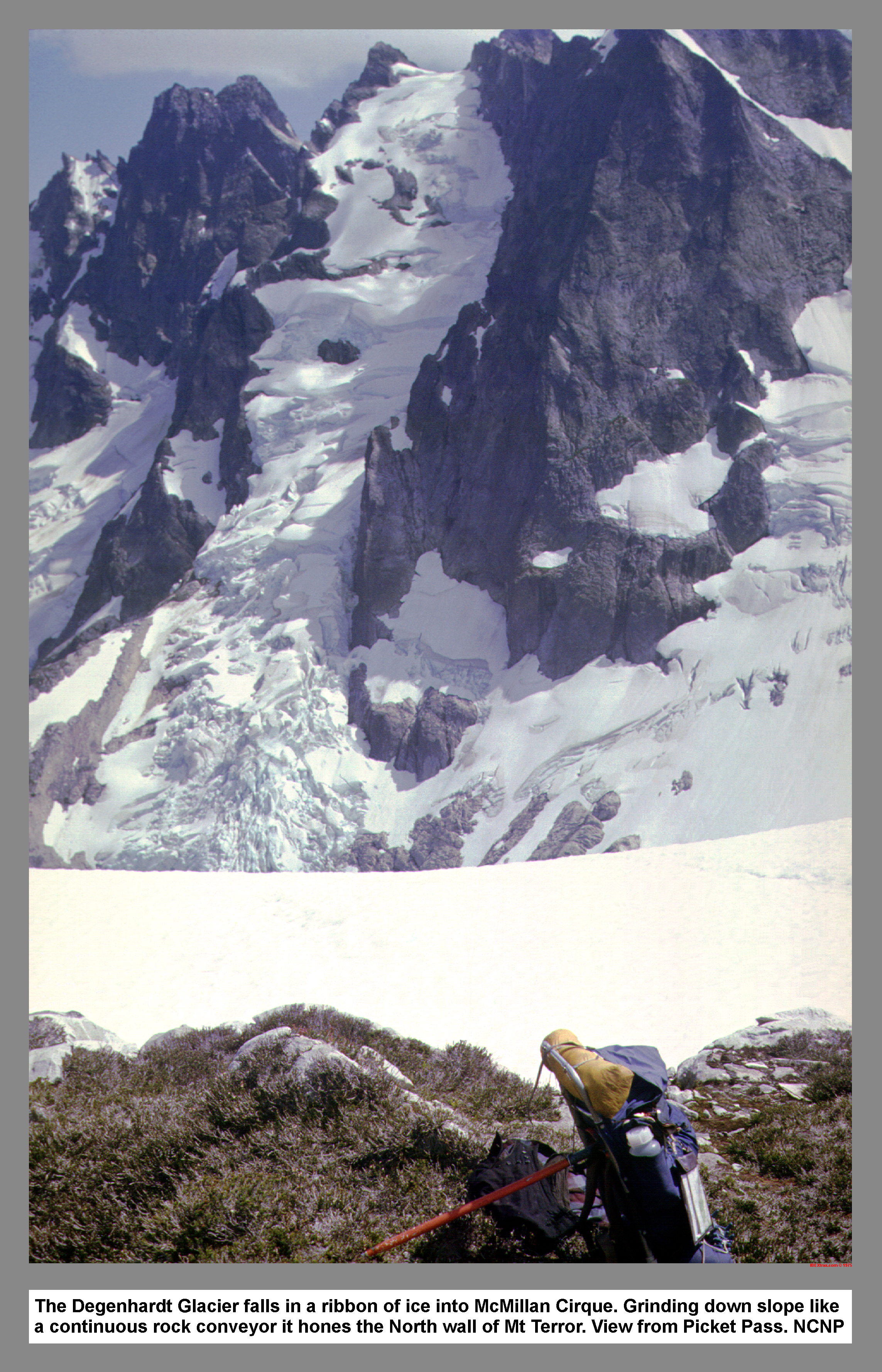 The view of the Terror Group was fascinating. While I cooked a lunch of clam chowder, I studied the glacier to the east of Mount Terror. The wide ribbon of ice was heavily crevassed. As I looked for the route that was in the Becky guide, a serac toppled over and avalanched down the icefall.
I was able to pick out Mount Baker as I climbed north from Picket Pass. The thunderheads in the east were soon joined by thickening alto stratus. At about seven thousand feet on the southwest ridge of Mount Fury, I was confronted with some technical rock work. The problem was a knife edge arete that was undercut on both exposures. The traverse would be only forty feet, but without a rope, I knew it would be a high risk. I backed down a few moves, but a slight gust of wind persuaded me to retreat and reconsider. I tried to piece together some of the moves, but my eyes wandered to the west to watch the gathering storm. I backed down again and tested the holds and the balance. In the middle of the traverse was a go-for-it move that stepped across to a sloping ledge. I kept wondering if there were other places like this ahead. I climbed back up. I reconsidered my scheduling problems and stood in the increasing wind, thinking through a new plan. I stood on the ridge for a long time. I eventually decided to drop back down to the pass, and then escape via Elephant Butte high route.
I pitched my two-man tent in a sheltered alcove that was protected from the gusting southwesterly. At sunset the cirque came alive with the echoing boom of falling ice. That night I slept on top of a heather clump, trying to stay dry. The wind blew the rear tent vent inside out, and then the rain tunneled in.
On the morning of the 28th there was no sunrise. A thick drippy mist hung in Picket Pass. It was after twelve when I ate breakfast. I was concerned about negotiating the glacier in the low visibility. I reasoned that, "If I stay at the pass, I will only get wetter."
I stuffed my sopping equipment and headed down. I retraced my route down across the glacier and around the waterfall. As I scrambled down the obvious ledge, I noticed that the clouds were breaking up. The sun poked through as I enjoyed a fast glissade down the slot. I skated over to the snow-covered lake, and then followed the guide route up the creek and along the key ledge. I had kept careful watch, but there was no icefall. It was a long steep trudge to Azure Pass. I noticed the snow melt as I climbed over the rock island. From Azure Pass I took a last look across McMillan cirque. Picket pass was still socked In. I covered a quick mile east of Azure Pass before I found a super camp spot. The sun winked in and out as I cooked the evening meal. As the sun set the clouds dissipated and the temperature dropped. The bottom of my sleeping bag was wet.
Tuesday morning it was gray and misty, so I slept in. After I broke camp, I traversed east in the fog, using my altimeter and compass. In numerous places I had to drop down to the next bench due to the tilted pattern of the strata. I crossed the southeast ridge of Elephant Butte at sixty one hundred feet. It was, "Follow your nose and hope it goes" as I swung down a cliff on tree limbs.
It was chancy guess work to navigate in the fog and I found myself talking to myself. My map reading experience was paying off, and I soon found myself standing at the outlet of lake 5135. I reset the altimeter.
The guide said, "Game trails", but I didn't find any. It was a short battle with brush that was sopping wet. I gave up the fight and followed an opening in the brush. I jumped two creeks and climbed down a dirty gully on tree roots. From the bottom of the gully, it was an easy traverse to the pass. On the wooded side hill east of the pass, there were many goat trails that crisscrossed the slope. The fog broke for a moment, and I saw the setting sun on an unknown peak. The fog closed back in, and I started looking for a camp. The search ended on the ridge top, and I pitched the tent amidst many goat tracks. The clouds suddenly rose and exposed the breathtaking view down to Big Beaver Creek.
It was another low visibility morning on my last day out. Soon after I set out, I walked off my map. The plan was to follow the ridge until I reached the Sourdough Lookout. There was a chilling wind at the ridge crest, so I traveled on the south side. After a few hours into the traverse, the weather cleared momentarily and revealed a shortcut.
It was noon when I saw Sourdough (Jeanita) Lake, and soon I was following the trail markers. I saw the lookout in a break in the passing clouds. I slipped and took a hard fall on a small snow patch, and it reminded me of the dangers of solo hiking. Near the lookout, I guessed at what the guide said, and took a short cut down mountain goat terrain. I saw a deer on a flat just above the trail.
Once on the trail my stride stretched out. There was a view of milky blue Diablo Lake. Sourdough Creek was a tree tangled avalanche track. I passed the first people that I had seen in five days with only a "Hi". My feet didn't like the trail, but I persuaded them on by saying, "This is the last leg." The grade of the trail was just right for gliding.
I passed a boy with a blanket and oxfords, and soon after, another detachment from the boy's family. I came across the family core at a refreshing water hole. I talked with Pa while Mom tended Sis' blisters. When they asked, "How far?", I misread the altimeter.
I watched the altimeter as I descended, and soon I passed a big sign that marked the park boundary. The trail seemed to go on and on, but I kept pushing my sore feet. I stopped for water at a small abandon water reservoir, and as I drank, I wondered, why it had been abandon.
It was quite a shock to go from trail directly to sidewalk. I popped out near the balloon covered swimming pool. The traffic was light as I walked through the housing project called Diablo. While I walked to the highway, a few big cars passed my outstretched thumb. I covered a quick mile on the road, and finally was picked up by a local restaurant builder. I thanked the builder as I climbed out of the truck at Newhalem, and then was relieved to find the Pinto OK. After I released my feet from my Galibier torture chambers, I drove home in the sun. I knew I would be coming back to further explore the Picket Range.
|
|
|
|
|
|
This site created and maintained by THE IBEX - Page last revised:
|
|