
|
|
IBEXtrax.com - Cascade Mountains of Washington StateSnoqualmie Forest - Unprotected |
|
|
Chris H and I had made arrangements with Tom B, Paul B and Cat. I would park the Cortina at Snoqualmie Summit and they would drive it back down to Asahel Curtis Picnic Ground. Then they would meet Chris and I at Annette Lake at the end of our loop trip.
It was afternoon when we drove up to the Visitors Center on Snoqualmie Pass. There was a slight problem finding the PCT trailhead. The Beckey Guide said that the trail begins at the Visitor Center then follows marked posts. There was no sign of the trail at the visitors Center. We drove around the parking lots and finally found the trail sign in the upper east parking lot. We put on boots and shouldered our packs. We hiked slowly up through the ski area. The Snoqualmie Summit Ski Area is not the most scenic late spring hiking. I enjoyed downhill skiing in the winter, so I could not easily condemn them for the intrusion in this alpine area.
Chris and I followed the muddy cat track to a saddle were we found Beaver Lake. The trail passed the lake to the east and we followed it into a stand of fir trees. The descent to Lodge Lake was pleasant. We followed the Pacific Crest Trail signs. I knew the lake campsite was occupied before we saw the lake. This was due to the smell of campfire smoke in the air. I remembered the time I was up Thunder Creek Trail and I could smell or sense people ahead. We dropped our packs along the trail and then we took the side trail to the lake shore. The short trail ended in a rundown campsite at the north end of the Lake. Water was standing in the middle, occupying the only possible tent site. Up on a rotten stump was nailed a Forest Service sign that had been vandalized by a trigger happy hunter. I wondered why anyone would shoot up a sign. Across Lodge Lake a family was camped. The smoke from their fire hung over the lake. A fatherly type with fishing pole in hand stood at the bank. I noticed a frog jump into the water just five feet from my feet. I watched the ripples spread out into the lake and blend in with the droplets of "Oregon Mist" that joined the waters of Lodge Lake.
Back on the Pacific Crest Trail heading south, we passed two small ponds and then hiked into dense second growth timber. The narrow trail traversed a steep side hill that fell off to the right. We passed a connecting trail that dropped to the highway. A sign pointed down indicating the steep descent.
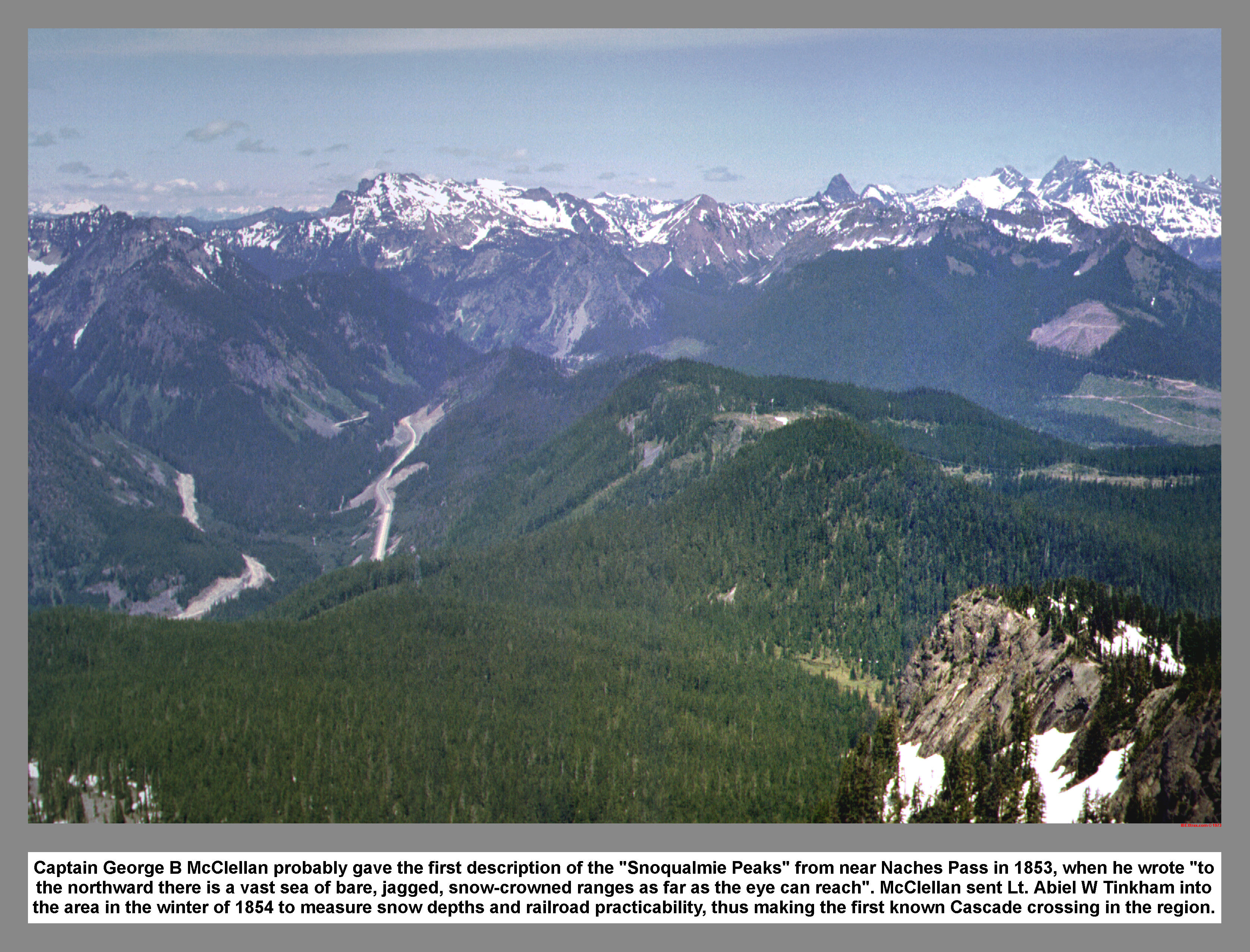
We came next to an opening and we viewed the valley to the West. The traffic on Interstate Ninety was light. The loud blurt of a Jake-brake echoed across the Snoqualmie River Valley from Granite Mountain. I pictured the view from the highway looking up, and remembered the reflector board above. I told Chris that we were in the radio slash and that microwaves above our heads carried hundreds of telephone conversations. He threw a rock up and we wondered who he had interrupted. We continued past the "Danger High Voltage" sign and crossed under the humming light of the Bonneville Power Administration. The trail passed thorough an andisite rock slide and crossed a small creek I called Rockdale. Above the creek the route followed the power line service road. When I saw the motorbike tracks, I thought of the sign at the trailhead restricting motorized use on this trail. The trail left the road and continued up. We stopped for a rest, I got cold and then continued on ahead.
Just before reaching Olallie Meadows, there was a tall tree supporting a large wooden box. The box was mounted thirty feet off the ground. I climbed up the ladder and found snow measuring equipment inside.
We crossed Olallie Creek and picked a camp spot at the south end of the meadow. Olallie Meadow was a quarter mile long and a few hundred yards wide. The open area was surrounded by lofty stands of mature Fur and tall, moss draped Hemlock trees. From the southeast corner of the meadow, there was a partially blocked view of Silver Peak. Only the North Shoulder could be seen rising above the tree tops. The tent was pitched just off the trail. We cooked supper on my Sevea white gas stove.
While heating water for dishes, a muddy dog poked his nose under the make-shift vestibule we were sitting under. I climbed out and the dog began to bark. Moments later his master came into view from the south. He was carrying an Army pack, and his bed roll was over his shoulder. His long black hair was wet from the rain. As he came closer I noticed he was wearing saddle shoes. Smooth sole, low cut, two tone loafers. I asked were he was heading and was surprised to hear him say Oregon. I was speechless. So, Chris restarted the conversation. The further the conversation progressed, the more certain I was that he was not going to make it all the way to Oregon. Chris pointed out the second choice camp spot across the meadow. As soon as he was out of hearing range, Chris said that the young through hiker was going to have his hands full; going 300 miles without boots or rain gear.
We finished dinner and went exploring in the meadow. Olallie Meadow was boggy. It had a creek that twist and turned down through the center of the meadow. At the upper end of the meadow were a few snow patches. We decided to have a stick race. We each gathered likely "boats" and launched them into the creek. After loosing many boats, jumping the creek innumerable times and thoroughly tiring ourselves, we returned to the tent and bedded down for the night.
In the morning, I climbed out of my bag, dressed and left the tent. During the night, frost had whitened the meadow and the rain fly was encrusted. The dog across the meadow began to bark. I looked up at the blue sky and watched the sunlight creep down the west side of the valley. I went up the west side slope to meet the sun. I stood on top of a fallen log to absorb the heat.
We ate breakfast and then broke camp. While waiting for Chris to finish packing, I went across the meadow to get a better view to the south. Just beyond the North Shoulder was the summit of Silver Peak; one of our objectives.
We hoist our packs, waved goodbye to the barking dog and went up the trail to meet the snow. The trail was easy to follow in the untracked snow and we made good time. We passed several slide areas, were snow had avalanched down off Silver Peak. These clearings between the trees provided good views down to Lake Keechelus.
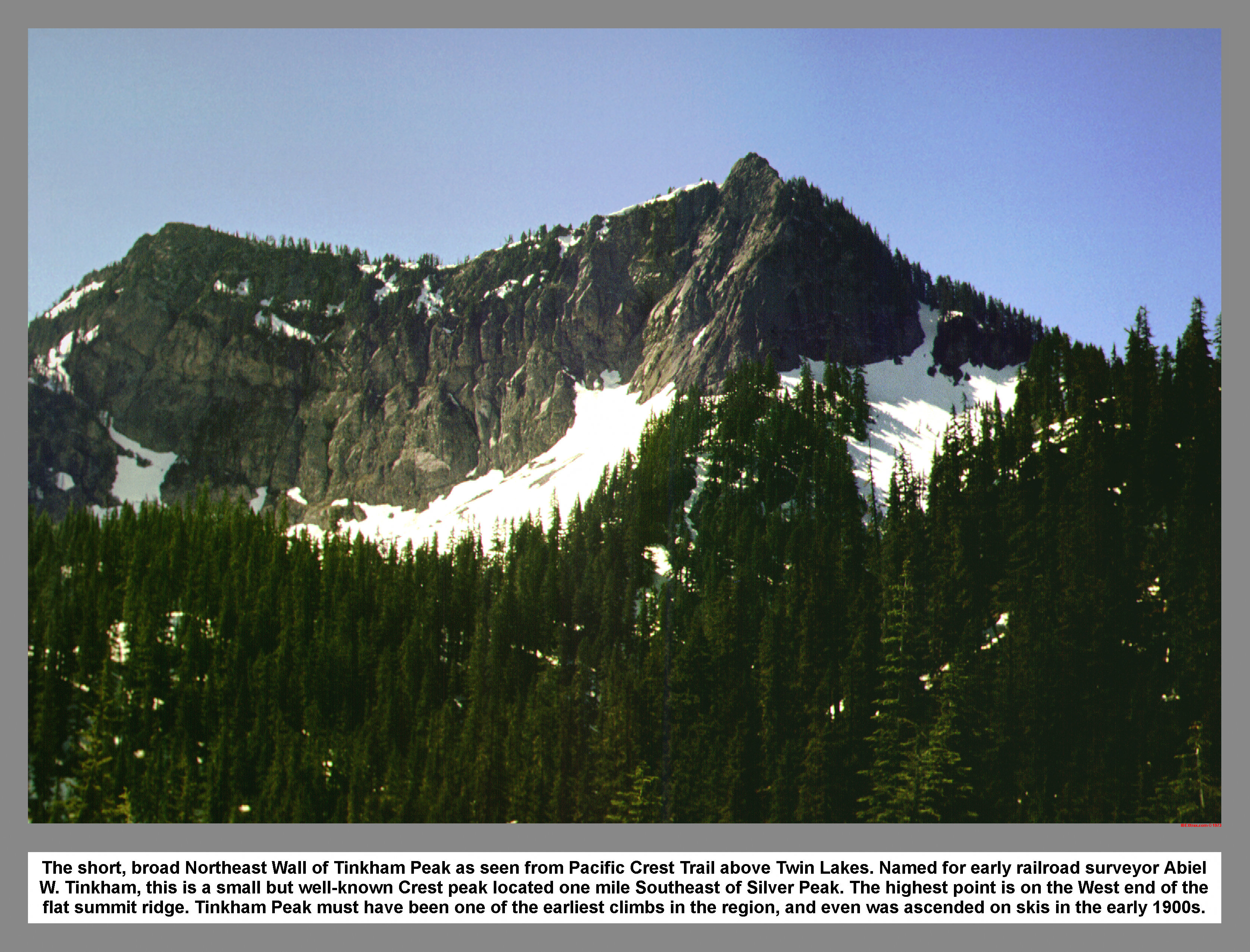
At the flat below the Silver - Abiel saddle, we found the first breathtaking view of the North Face of Tinkham Peak. After putting on sunglasses to protect our eyes from the brilliant light reflecting off the snow, we left the Crest Trail and climbed up the steep snow. We were aiming for the high pass above Annette Lake. The plan was to camp in this high pass we called Abiel Pass.
I was the first to break over the crest. I was confronted with the snow covered meadow land of the pass. First thing was to search for water and secondly to find a campsite for the tent. We finally found water, after digging with our ice axes in a depression, just east of the pass. We set up the tent on the snow just above the water hole. From the tent we could walk a few strides west and gaze down on Annette Lake.
After making camp, we packed our rucksacks and started up Silver Peak. Just up the first rise, while climbing on talus, we met a climbing party coming down. They told us of the arduous ascent from Annette Lake, of their plans to climb Tinkham Peak and their planned exit along Humpback Ridge.
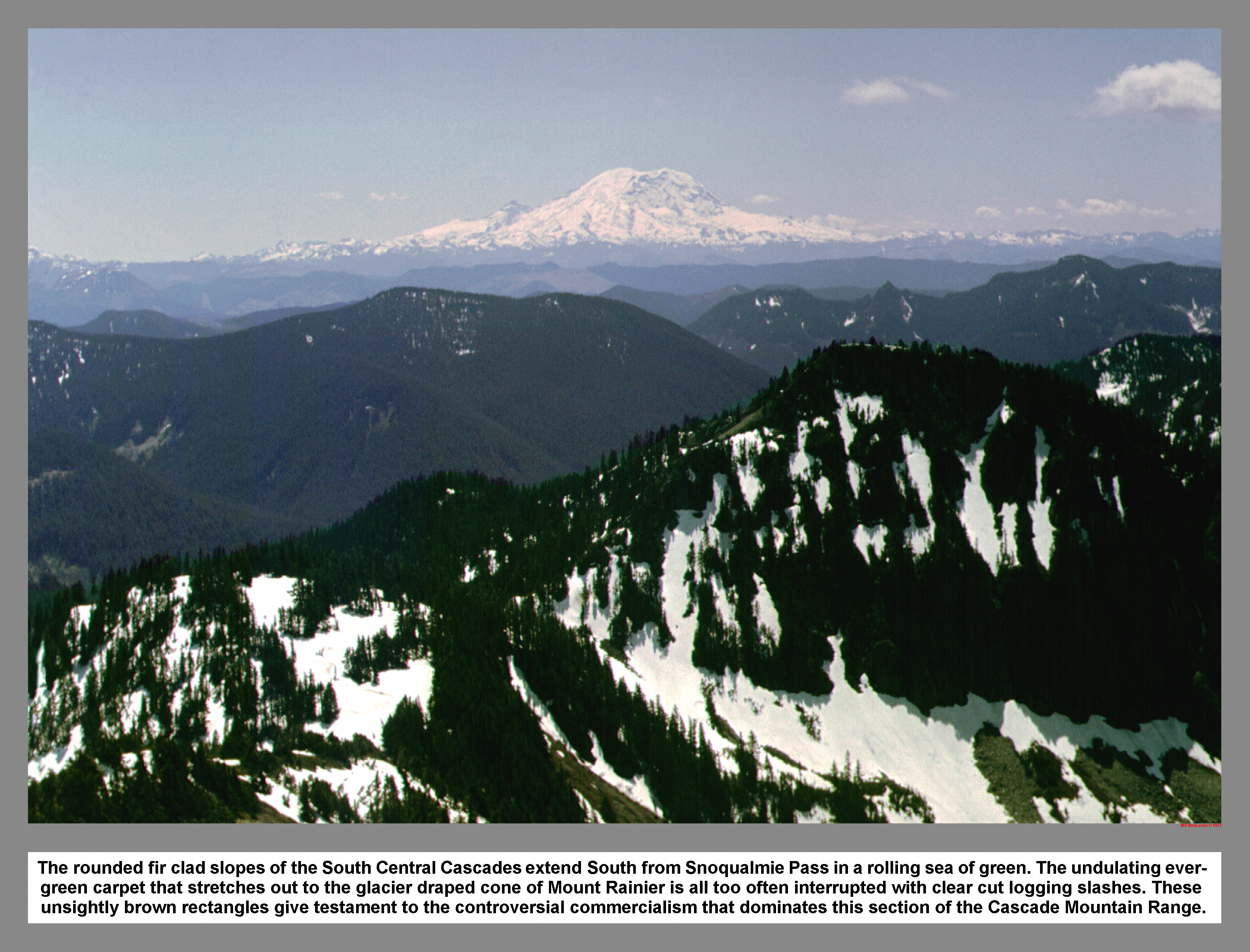
Chris and I continued up, following the South Spur of Silver Peak. We were walking on an aging cornice. Momentary rests were enjoyed by looking south between Tinkham and Abiel Peaks to see Mount Rainier. The clear skies provided undistorted views and crystal clear details of Willis Wall. Each step in elevation gain was rewarded with a more sweeping view of the massive volcanic cone.
When we reached the summit we agreed it was a very clear day. We sat on the summit and enjoyed the splendor of sight. I used a map to acquaint myself with the peaks to the north. I mentally named the familiar summits I had stood upon. We signed the summit register and were joined by a young couple with a baby riding on fathers back.
After a bit of lunch we made a quick descent. We used a skating glissade to descend the broken down cornice. We were careful not to challenge it's cohesion by sliding too close to the edge.
When we reached the tent site, we decided not to waste such a fine clear day. We started toward Tinkham Peak. At the Tinkham - Abiel saddle we found "No Trespassing" signs posted every forty feet. The signs told of the watershed owned by the City of Tacoma and of the fines for trespassing. Continuing southeast along the watershed boundary, the slope gradually steepened until we were kicking steps up the slope. Our course angled right and we climbed in the trees for a short time.
We came to the rocks of the West Summit and applied the rock climbing skills we had studied at Sherman Rock. I came to a more difficult pitch with a slight overhang. It provided an exhilarating test of courage. I started the pitch with a confident skill that began to diminish as the exposure increased. Without the companionship of my rope, I stalled within a few moves of the summit and had to traverse right to more protected climbing.
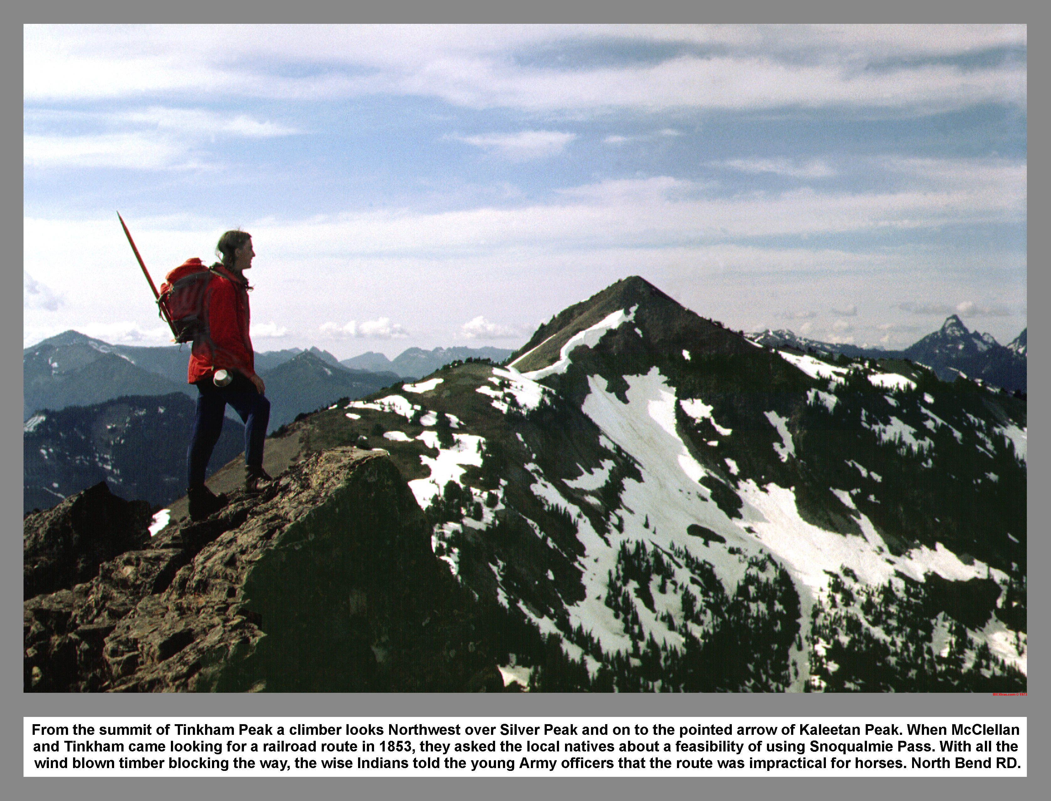
Chris joined me at the top and we discussed the adventure of the last pitch. We each confessed our detours in the last part. We linger for a short time on the lesser West Summit, and then strolled over to the true summit were we read and signed the register. I looked down on ice covered Mirror Lake and thought of the Oregon-bound hiker and his barking dog. I knew the Crest Trail passed beside the lake.
The descending sun was low in the west, so we went back over the West Point and went down a couloir filled with loose rocks. There was a hard move where the rocks met the snow. I jumped into the glissade position and flew down the chute. Chris reluctantly followed. We traversed back through the trees and came to the steep snow slope above the kicked out steps from our ascent. It was a fast glissade down to a flat run out. We reached Abiel Pass camp just in time to absorb the last rays of the setting sun. We sat at the pass and watched the wind ripple Annette Lake nearly two thousand feet below.
When the sun winked out behind the Olympic Mountains, the temperature dropped like an express elevator. I removed my wet boots and wrapped my warm-up pants around my feet to stay comfortable. My feet were just beginning to feel warm when I had to go get water. I grumbled down to the water hole and tediously searched for sediment free water to fill all of the containers. After finally filling all of the pots and bottles, I managed to drop the largest pot, spilling its entire contents. In discuss I threw the other pot down in the snow. After refilling the pots, I climbed back up to camp with numbing fingers.
After supper I arranged my equipment under my bag before I crawled in. I was wearing my down sweater and warm-up pants inside my sleeping bag. It was a cold night. But, I was too tired to keep from sleeping.
At sunrise I awoke to find the yellow taffeta of the tent roof two inches from my face. The wind was blowing and the rain fly was flapping. However, the sun was shining. Chris got up and re-staked the tent. After I left the warmth of my sleeping bag, we cooked and ate breakfast. We discussed traversing to Annette Lake via Humpback Ridge over the top of Abiel Peak. But, we eventually decided to drop directly down to Annette Lake and spend the night. As we broke camp, I suddenly had a thought of my car. I knew I left my lights on.
Neither Chris nor I were up to climbing over the top of Abiel Peak with full packs. So, we left the snow in Abiel Pass and glissaded down toward Annette Lake. Where the snow thinned and the slope leveled out, I followed my nose through the dense timber. We encountered many small streams and became engaged in a strenuous battle with thickets of slide alder and vine maple.
I finally broke free on the northeast shore of Annette Lake. With a mighty growl I escaped the strangling brush and popped out wild eyed near a surprised group of girl scouts. The leaders scurried the young girls away and allowed me to stomp loudly down the lakeside path. Near the outlet I cooled down and watched Chris make slow progress against the brush. When Chris finally arrived at the lake, we hiked around to the west side of the lake. We met two young men that told us of their climb of Abiel Peak. We made serious inquiries because we were anticipating our own ascent.
We found a likely campsite and made camp near the spot I had camped at many years before while in the Boy Scouts. With the tent staked out, we repacked our rucksacks and set out to climb Abiel Peak.
Upon reaching the south shore of the lake we climbed straight up an avalanche fan. I laboriously kicked steps in the hard packed snow. We ascended a steep wash that lead to an open cirque that was filled with talus from the North Wall of Abiel Peak. We made our way to a rock slide that started with large boulders that diminished in size as we gained altitude. I took pride in my precise foot placement; being careful not to dislodge a rock that could descend upon Chris. At the top of the slide, now transformed to scree, was a steep pitch of snow. The steep snow brought us to the moat, where we found tracks from the previous party. There was an apparent cul-de-sac that shot right and disappeared from view. It was slow going as we stemmed up between snow and rock.
I was leading as we topped the crest of the gap. Beyond the gap, the majority of the view was filled with air. That is, the exposure down the Tinkham Creek drainage was huge. The only path of ascent was via a fir needle covered sloping ledge. I cautiously traversed the ledge using small shrubs for handholds. I then made a "sand and cedar" move that Mount Index enthusiasts would be proud of. When Chris reached the col and saw the treacherous ledge, he exclaimed that he had had enough. I was heartbroken and wished I had my rope. I was now confronted with reversing my steps across the sloping ledge that Chris had made so notorious. I edged back onto the ledge and moved with smooth motion across the needles. I was trying to show Chris how easy it was, in hope that he would change his mind about continuing.
I safely reached Chris in the col and stepped upon a large flat rock that immediately gave way beneath me. I was thrown off balance. I lunged for the protection of a fir tree that Chris was leaning against. I surrounded both Chris and the tree in a clutching bear hug. Looking over my shoulder, I watched in horror as the large rock bounded into the abyss south of the col. I regained some composure and my heart started beating again. I was now more agreeable with Chris' idea about turning back. The view from the col wasn't all that bad. So, we heated up some soup and ate a leisurely lunch at this high point. We talked about premonitions and other factors that relate to turning back in the mountains.
We made our way down from the col by descending facing-in with our ice axes in the self arrest position. Chris slipped and made a sloppy but successful self arrest. I told him what I thought he did wrong, and we both practiced arresting a few times. We traversed left at the cul-de-sac and then made a long sweeping glissade down the west side of the talus slide. We skated over to the wash. I made a running start and shot off down the wash. I quickly stopped after jumping an opening in the snow. I warned Chris not to follow my tracks and he swerved around the hole and stopped. I led on, down to the lake. Just above the lake, I noticed the low clouds creeping up the valley.
The sun sets early in a deep mountain valley. So, we started preparing the evening meal as soon as we reached our camp site. By the time we had finished eating, the tip of Silver Peak had turned pink from the setting sun and the cirrocumulus clouds were thickening. I slept well, now that we were off the snow.
In the morning I looked out of the tent into the rain and mist, and I decided to sleep-in. After lying in our bags well into the morning, we rose and cooked breakfast under the plastic tarp. The rain stopped as we finished our cups of cocoa. So, we went down to the shoreline to wait for Tom to make his appearance.
Paul appeared bare-chested at the outlet and came around to the camp. I let him use my O.D. T-shirt to dry-off, while he told us of his hike in from the road. Paul told me that my car battery was dead and they had to use a compression start the Cortina to get it down to Asahel Curtis Forest Camp. I mentioned I had a feeling I left the lights on. Tom and Cat soon arrived, looking very under the weather, with sopping clothes and dripping locks.
Chris and I pointed out our glissade tracks from the previous day. They extended up into the mist. Paul, being an avid glissade enthusiast, proposed that we go up so he could try his skill on the steep snow. Chris and I happily agreed and surprisingly Tom wanted to join. Cat was content to wait from a warm distance.
The four of us traversed the shoreline to the wash. Tom decided he would go back to Cat and he lent Paul his ice axe. Paul, Chris and I went up the wash, using my day old steps in the steep snow. Upon reaching the talus slide, we ascended in echelon formation to prevent injurious rock bombardments. From the top of the slide we scaled the steep snow to the moat. At the top we ate pilot bread smothered with cheese.
After eating, I went down first. I slid down a few meters and made a self arrest. Paul was next; He performed a short Walden exhibition, terminated with a slip and arrest. Chris followed, executing his arrest with modest confidence. We traversed east to clear the rock slide, and then regrouped on a snow arete. We decided to go all at once. We counted to three in unison and made a running start. The sound of exuberant yells and flying snow enhanced the exorbitant experience. I was traveling between Paul and Chris, slightly behind. The slope was lightly sprinkled with assorted rocks, which had fallen from the North Face of Abiel Peak, embedding them in the snow. Depending on the size, the resulting crater was proportional.
We were cruising along, holding a tight formation, when I saw a likely crater rushing toward me. I decided, in a small space of time, that I would jump the crater as I had jumped the crack in the wash. I pitched myself forward and cleared my obstacle with distance to spare. My lack of planning was evident as my upper body was a full stride ahead of my feet. My survival instinct automatically activated during the touchdown. I hung on the tight rope of balance. I managed to upright myself by dragging my axe in the snow. By the time I had conquered the crater; my companions were near the bottom. I had lost much speed. I made a few running starts. Paul was sitting on his haunches and slipping along with ease. As we regrouped at the top of the wash, I warned Paul of the crack and then I shot off down the wash. The final descent was non-stop until my flight was terminated in a grove of Devil's Club. I looked up in time to see Chris make a jump through an opening between two trees. We gathered on a large boulder near the lake and shared our stories of the descent. Paul said he had had longer glissades, but this was his first of the year.
Back at the camp, Tom and Cat had a smoky fire going. Chris and I broke camp and we all started down together. Chris almost lost his way in the deceiving switchbacks. By the time we reached the railroad tracks, it was dark. We walked down the road together and then crossed I-90 to the cars.
|
|
|
|
|
|
This site created and maintained by THE IBEX - Page last revised:
|
|