|
|
IBEXtrax.com - Cascade Mountains of Washington StateWenatchee Forest - Teanaway Ski Trips |
|
|
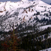
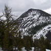
I went up to the Teanaway Country during Memorial Day weekend 2002. My customary, overly ambitious plan was to bag all Three Brothers summits, Earl Peak, the Volcanic Neck, Bean Peak, Bills Peak and Iron Peak.
I was packed Thursday night (except the stuff I forgot) and then brought my snow camping gear to work on Friday. At my normal get off time (1:30PM) I left Boeing Everett and then headed south to drive over Snoqualmie Pass. The traffic had a good flow and as I crested the pass, I thought I had broke free and clear of the Puget Sound megopolis.
On the Kachess Slope that drops from the base of Amabilis Mountain, the down hill stretch that everyone likes to speed, the state DOT posted a flashing warning about an accident ahead. We all slowed down to gawk at the wreck that never appeared. Eventually the group consensus concluded that we were caught in a ruse; and the speed cranked back up as we cleared the Easton sidings.
I jumped off I-90 at the east Cle Elum exit #85 and then followed highway 970 through the quaint hamlet of Teanaway. The smooth blacktop followed the Teanaway River upstream. The river was running at full song with the spring melt. Soon I turned again to track along the Teanaway River Road. It followed the wide valley of rich farmland that was lush with spring growth.
The route continued straight up the North Fork and on to Twenty-nine Pines where the pavement ends. The Campground was filling up fast and I felt a tinge of compassion for those that thought they were getting a true wilderness experience. I drove slowly up the dusty gravel road; very conscious of the billowing rooster tail of dust that rose behind me. Shortly I crossed Stafford Creek and kept to the right on F9703. A few bumpy miles later I reached the Stafford Creek Trail #1359 and parked on the shoulder next to the trailhead.
It was near 4:00PM when I started my traditional Bon Voyage ritual. The process includes a dinner of fresh fruit mixed with fat-free cottage cheese and skinless poultry meat on the side. I also tape my feet (plantar fasciitis) and change into my mountain outfit. The whole time I gorge myself with as much water as I can stand. The temperature was hovering near seventy at the altitude of three thousand feet and it was grossly obvious that my Capralene plus Windblock attire was out of place. I had forgotten my shorts and I didn't want to gross out the animals, so I didn't have a choice.
I glanced into the one other car at the trailhead and noticed a copy of Harvey and Ira's latest guide along with a Boeing badge hanging from the mirror; James something? He was displaying a 3X$5 daily pass with a camps location of "Everywhere". Maybe I will see him? From my mirror hung a WTA earned volunteer Forrest Pass.
As I eased into my rudely overweight pack with its obnoxiously long skis sticking over my head, a redneck type pulled up with his scruffy woman on one arm and a brew in the other. He parked his rumbling rig in the middle of the road, staggered over and commenced to brag about his elk hunting trips of thirty years ago. He tested me with a few key questions that I knew answers to from my two recent trips along the trail. It was soon obvious he wasn't going to be able to BS me to his hearts desire. So, he rumbled back down the road and left me to the chore of lugging that Winnebago sized pack up the Stafford Creek Trail.
I settled into my normal one mile an hour speed limit and watched the world go by. There were lupine, Avalanche Lillis and miniature flowers I didn't know the names of. The trail had been recently maintained. The drains had been mucked out and a few spots showed retread work. There are a few bothersome one foot wide blow downs along the trail. The wood looked fresh enough to saw. They would be no problem for skiless travelers.
I crossed the first snow patches around 4200 feet and soon after, I stepped into my skis. I took them off a few times for dry ground. But, the NNN-BC bindings are painless to get in and out of. One rough spot is at three miles where a huge pile of avalanche debris blocks the way. You can look up and see on the west slope of Freedom Peak (6442T) were the sliding snow has sheared off the trees and only stumps remain.
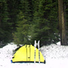
After crossing Freedom Creek*, I made camp in the snow covered meadow at 4800ft as darkness fell. I didn't have to melt snow as there was an abundance of babbleling springs around the meadows edge. I cooked a cuscus meal, but ate only a small portion; saving most for later. My knees were bothering me, but that's why they invented Ibuprofen. Six hundred milligrams; down the hatch.
Camping along a roaring creek like Stafford Creek in the spring can be like anything you want. The sound of the crashing, rumbling, splashing, tumbling water produces all of the frequencies of sound. And the sounds you choose to hear are as limitless as your imagination. When I am alone, I can hear voices. All types of voices; Children playing; boisterous arguments; my departed mother calling; a neighbors laugh. And there is music; all types of music; Pop; Country; Rock; Opera. I don't hear rap! So, being near a loud cascade in the mountains can be like anything you want.
It was raining hard, early Saturday morning. So I slept-in. Then after the rain stopped, I decided to let the tent dry off before I packed up. So, by the time I left the meadow camp, the time was closing in on mid-day. The snow had turned soft and corny. But, I traveled on top of the snow with my textured skis. Their textured bases bit into the slushy surface and I easily climbed up into the upper Stafford Creek basin.
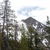
I took a long rest-stop at an open flat in the upper basin. I sat on my cushy, bulging pack and munched on a nutty trail mix. There was a good view across the basin of Earl Peak; with its gentle rolling ski slopes were I had played two years before. A wide variety of tall billowy clouds were blowing in from the west and their swiftly passing shadows provided an ever changing vista. I smeared on SPF 45 sun protection. But, I soon discovered that I forgot lip balm. Not a good thing for me because I thought I could feel those pesky little flora viruses start blooming already.
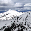
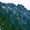
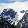 I slowly completed the last few hundred vertical feet to Navaho Pass and then stopped again to admire the expansive view. The Ingalls slope of the Stuart Range stretched from the Dragontail Plateau to beyond McClellan Ridge to the east. The myriad of sharp granite spires and towers, with names like the Nightmare Needles and the Knitting Needles, festooned the monochrome landscape. The varying shades of gray granite rock poked through the still deep, lingering winter snows. In the sheltered lee of a clump of stunted evergreens, the sun was warm enough to persuade me to take a nap.
 I awoke to the sound of voices; though I initially thought I was tricked by the sound of the wind in the trees. A young couple on snowshoes strode up to the pass. The powerful young man with clean shaven head and trimmed go-Tee answered "No" to my question if he was Jim. His attractive partner; a petite, tanned brunette, flashed her beautiful smile with a "Hi" as she crested the pass. She had a nice set of gaiters; amongst other noted attributes. These two would be the only two travelers I would see the entire Memorial Day Weekend.
I swung my bulky load on my back and climbed out of Navaho Pass; ascending east onto the shoulder of Navaho Peak. I skied up the steep snow with switchbacks; to reach a flat step near 6400 feet. This vantage above the pass was were I had camped in 2000; as it provided a good view west to Mount Stuart who's summit was now shrouded in clouds.
 The wind had picked-up to a steady cooling blow, and from my exposed position on the open slopes of the west ridge of Navaho Peak, I was easily persuaded to duck out of the wind and traverse around to the south side. I held an even contour close to 6500ft and searched for signs of the old County Line Trail #1226.
The traverse across the South Face of Navaho Peak was exciting to say the least. I laughed and laughed while imagining a sports announcer describe my antics as I negotiated each slight down hill section of the slope. The technique started in a low crouch, and I would grit my teeth with determination. Every muscle was tense and a heightened level of concentration was required to maintain the fine line of balance. The soft leather shoes I wore gave virtually no side support laterally. To compound the problem, my bowlegged physique made the outside edges of the skis dig into the soft snow. Turning or even skidding sideways was out of the question. And balancing on one ski was nearly impossible. So, with my skis wide apart and my knees knocked together, I would slowly push off; immediately looking for a place to land. Leaning forward, be it ever so slightly, was like a death wish. Earlier in the day I had fallen forward and crunched my toes horribly. I was afraid to remove my socks for fear of seeing mangled, partially separated toe nails. So, on I went; with speed increasing. Many trees covered the undulating slope. In the shadows near the trees the snow was icy, and in the open areas the snow was a slushy mush. Inevitably the low crouching position gave way to a hilarious display of jerky semaphore; with my arms flailing over my head. Sometimes I would jab my poles in the snow to keep from falling forward and other times I would drag the abused poles behind to keep from sitting back. Eventually the torture would end when I either sat back in the slushy snow or struggled to pull my head out from under my fifty pound pack. Finally after wallowing in the saturated snow to orient my skis perpendicular to the fall line; I pulled myself up from a tangled heap of skis and poles. Leaning heavily on my poles, I stood up weakly with my ankles rolled over and the ski bases facing each other. I sucked air from the exhaustion and glanced back up my ski tracks. I had covered a mere fifty feet; only a mile to go. I laughed loudly, and then crouched down and gritted my teeth with determination.
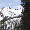
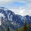
By the time I completed the harrowing South Face Traverse and reached the southeast ridge of Navaho Peak, I was ready to set up the tent and make camp. The wind was still blowing hard. So, I set the tent in the lee of a few gnarled evergreens. Located at nearly 6600ft on the rounded ridge crest; I named the camp Navaho Arm. And what a great view the camp site had. To the west were the rolling ski bowls around Earl Peak and arcing down to the south was the Stafford Creek drainage. Continuing down from Navaho arm was Freedom Peak (P6442T) and along the County Line to Miller Peak. To the east of the camp was the massive bulk of Three Brothers summit and the deep basin of Negro Creek. Finally to the north, and beyond the huge cornice that hung above Navaho's east face, were the jagged spires and towers of the Cashmere Crags and lower McClellan Ridge.
I cranked up the WisperLite and melted enough snow to make five liters. One quart was brought to a boil to rehydrate dinner. Another quart was mixed with PowerAde for immediate personal hydration. Two more liters were heated to sleep with in their Nalgene bottles. As the sun set the weather cleared and a huge full moon rose out of the flatlands of Eastern Washington. On my miniature FM radio I picked up a new country station out of Yakima. It was interesting to pick out the different pronunciations of the renowned east slope city. I have always pronounced it YAK-i-mhaw like flaw. But, I guess the locals say Yack-eh-MUH like mother. It was easy to tell which commercials were produced locally and which ones were not. It was clear and froze overnight. But, I was comfortable in my Marmot Pinnacle and duel hot water bottles.
 The sun shone bright after sunrise. But, I lazed around and waited for the snow to soften up. I cooked a leisurely breakfast of rehydrated fruit, instant oatmeal and Ed's Energy tea. After eating, I strapped my skis to my lightened pack and then followed the cornice up Navaho Peak. I had waited for the sun to soften the snow just enough; for my ski shoes made good steps up the ridge. Part way up the cornice, I picked up the steps of a previous climber; this made it easy to quickly reach the summit.
 As I reached the top of Navaho Peak, the view to the west revealed that the next wave of storm clouds was nearly upon me. I signed the register and then soon headed back down. I plunged down the softening snow with the skis still strapped to my pack. Near the top of Navaho Peak the slope was too steep and the cornice too narrow for my skill level on skis. After I plunge stepped nearly halfway down the ridge, I clicked into my skis and commenced to challenge the adhesion of the cornice. Mostly I did slow traverses with check Christies and kick turns. I even managed a few feeble snowplow turns across the fall line. This was all, right up my alley; the epitome of risk exercise. If I didn't make the turn on the right, I'd be impaled on the knarly stunted evergreens. And if I didn't make the turn on the left, I'd be catching big air off the cornice. It was like learning to swim from the deep end of the pool.
Back at the Navaho Arm camp I watched the weather come in. When I noticed that the heavy rain was mostly passing to the south, I decided to ski down to Negro Pass and then climb Three Brothers summit. I had to ski down the arm a bit to find a break in the cornice. At one point I hit a soft patch of snow. When I was pitched forward, I fought to keep from kissing my ski tips. Just as I caught my balance, I hit a slick patch. Back I went. My skis flew out from under me and I landed flat on my back. It was a very clean fall; ending with my ski bases straight up in the air. I laughed and laughed.
I slowly slid around the south end of the cornice and then made a few kick turn traverses. I eased down the steep between a few isolated trees as I convinced myself that the scrawny saplings were stabilizing the snow and reducing the chance of avalanche. After a few deep breaths and a concentrated gathering of courage, I then made a high speed traverse out under the ominous cornice. You must understand that high speed for me is maybe five or six miles per hour. If the cornice fell on me, I wouldn't be able to cash-in my REI dividend. So, I hurried on beyond the threat without stopping. The gentle rolling terrain above the pass was smooth corn snow and was very enjoyable skiing. Skis wide apart, knees knocked together and bend the knees. I must of looked very weird.
I stuck my skis in the snow and left them standing at the pass, and then headed up the mixed terrain of Three Brothers summit. The snow was soft enough to posthole. So, I kept to the rock and scree as I climbed the West Ridge. I tried to keep true to the ridge crest, but it was too time consuming to scramble over the harder rock steps. There was always an easy way, either left or right, around the few short cliffs. Half way up the thirteen hundred foot climb, I took a break to drink Gator Aid and munch down a Power Bar. I watched the thick sheets of rain pour down on the Teanaway Valley. A few drops of rain wandered up Stafford Creek and made me pull on my GorTex while I rested.
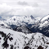
 An hour later after huffing and puffing, I came to the crest of Three Brothers Summit and found the flat summit area. From the West Point I took in the view up the Stuart Range. Mount Stuart still had its head in the clouds. At the head of the valley the three different Ingalls Peaks stood guard to the source of Ingalls Creek. Close to the west was the gentle looking rise of Navaho Peak with its easy slope that swung south to my camp on Navaho Arm.
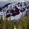
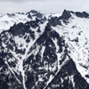 The north view across the deep trough of Ingalls Creek was The Enchantments jagged wall. The impossibly sharp towers and crags of the Nightmare Needles stood out in dream-like contrast to the blanket of snow that covered The Enchantment Plateau. The whole view was almost unreal because the scene was totally void of color. The gray sky, the gray snow, the gray rock, the gray trees. But, I was happy to be there. I signed into one of the two summit registers and then read a few entries. One of the later notes told of how interesting the other register was. I eagerly fumbled with the lid as I hurried to opened the second register. It was empty. Ha ha ha, I was tricked.
 On the way back down the West Ridge, I easily bypassed all the rocky steps on the south. My wise old knees searched out all the soft snow patches to cushion the descent back to Negro Pass. And how very soft the snow was; up to my knees in spots. I remembered not to step down slope from a tree top or a rock. I knew the snow creep left little moats that could snap my brittle bones. "Choose carefully each step." is the motto of the solo mountain traveler.
It was warm and I was sweating as I reached the bottom of the ridge and neared Negro Pass. In a horrifying mental flash, I masochistically imagined that my skis had fallen over in the hot weather and slid down thousands of feet to be forever lost along Negro creek. Or worse; one went north and one went south and I was doomed to wallowing out in the molasses-like slush. Wide eyed, I turn the last corner and scanned for my skis; My Saviors. Alas, there they stood. My loyal skis stood in rigid attention, obediently waiting for my return. Geezz. Why do I imagine this stuff?
I stepped back into the ski bindings and followed my tracks west from the pass. The track snaked around rolling knolls and between tight clumps of alpine pine. At one point, the dark clouds that had been threatening rain all day, finally gave in with a soaking deluge. With a great stroke of luck, I effortlessly eased under a convenient clump of dense evergreen trees, sat down on a dry grassy hump and then watched the amazingly heavy downpour. There was hail and buckets and cats and dogs. Where did they get that cats and dogs thing? As it started to let-up and I thought it was raining harder under the trees than outside, I struggled to my feet (still had skis on) and then continued on to my predetermined meeting with The Cornice.
 I quietly approached The Cornice. But first I needed to make some yellow snow. I had learned during my earlier rock climbing days a few physiological facts. It seems there is this chemical that your body secretes that condenses your urine under normal conditions. However, this particular chemical is not produced when you are fearful or under stress. The result being the need to pee more frequently. So the saying, "He was so scared he pissed his pants." is actually founded under this physical condition. When finished I then skied on to challenge The Cornice.
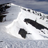
The Cornice knew that I would be coming back. And it had spent the day festering over the scar I had etched across it's face. So without surprise, I revealed myself from the cover of the last tree clump and boldly skied up to meet The Cornice; face to lip. The threatening Cornice stood ominous above me. It's two thousand foot length heavy from the recent rain and softened from the afternoon heat. It was primed to crush me with the slightest or lightest trigger. Just then, from a squall parked over Swauk Pass, came a booming clap of thunder that echoed around the basin. I was glad I had drained my bladder recently. The thunder must have surprised The Cornice too; It just hung there; frozen in place. So, I raised up my palms to the side, shrugged my shoulders and then quickly ski back up the track to my tent on Navaho Arm.
 I cooked an early dinner and then lazed around the camp watching for the sunset that never materialized. I listened to country music out of Eastern Washington and sipped hot cocoa spiked with Jameson. The gray day just turned darker gray. But I felt good to have bagged two more summits. And I felt lucky to be able to visit again my wondrous Cascade Range.
In the morning I waited for the snow to soften before I packed my gear. Instead of traversing back to Navaho Pass, I decided to ski straight down to the trail junction at the base of Navaho Peak. Skis wide apart, knees knocked together; I crouched down, grit my teeth with determination and then pushed off down the South Face of Navaho Peak.
Paste Story Here.
Paste Story Here.
|
|
|
|
|
|
This site created and maintained by THE IBEX - Page last revised:
|
|